Photo courtesy of Tim Luard and Alison McEwan.
This is one you'll want to view full-screen. To switch to full-screen, click the Zoom tab, click the '[]' icon at top left, then use the '+ / -' to zoom in and out.
If you can identify any of the buildings, please let us know in the comments below.
Date picture taken
1900s
Gallery
Comments
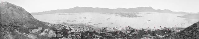
What an amazing photo
What an amazing photo showing so many buildings so clearly.
I'll start, left to right.
(On the Peak)
Bahar Lodge -
Meirion -
Tor Crest -
Bishop's Lodge
(Old Peak Road)
Luginsland-
St. Andrew's ;
Victoria Lodge -Charter House ;
Queen's Gardens
Indexing Of Buildings
David - time permitting, it would be great if the major buildings or those on the Peak could be indexed.
The 1901 PWD Report mentions the Prince's Building southwestern corner and HK Club Annex were in progress of construction, so 1900/1901 is more or less correct.
Yes, worth indexing - give me
Yes, worth indexing - give me a day or two and I'll update it.
David,
David,
Would the photo owners allow me to post it to my Gwulo links Flickr account so we can tag the buildings?
I've uploaded an annotated
I've uploaded an annotated version. Not every building is named, but hopefully there are enough letters to identify which part of the photo we're looking at.
Annelise, I don't think the Flickr annotations will work well in this case because we can't zoom in on it, meaning the annotations will be too crowded.
Regards, David
Kam Shan (Golden Hill)
Greetings. Kam Shan is beyond the eastern part of Stonecutters Island. One night in the autumn of 1954 (or about), I could see a long trail of brush fire two-third way up on that hill, likely started by hikers who were looking for excitement.
From there eastward, it appears the ridgeline remains lower than Kam Shan until one reaches Lion Rock. Thus, I am surprised Beacon Hill is higher than Kam Shan as Wikipedia gives these elevations: Lion Rock 495 m; Beacon Hill 457 m; Kam Shan 369 m. Is/are my geography wrong, math camera optic, or curvature of the land?
Building List
Thanks to Annelisc for B to K. Please comment if you spot any errors. I have created places if there was none previously for the below.
A Mountain Lodge?
B Bahar Lodge
C Tor Crest
D Meirion
E Bishop's Lodge
F Ian Mor site:
G Luginsland
H St. Andrew's/Inverugie
I Victoria Lodge
J Charter House
K Queens Gardens
L Building situated roughly where Yukon Court/Robinson Garden Apartments are today
Half way between L and P is Stonehenge. A small second floor can be seen poking up to the left of the trees
Above and to the left of Stonehenge are Belios Terraces
The junction up and to the left of L is where Robinson and Seymour Road meet. (Where the trees are) The crescent shaped building above this is Elliot Crescent
M Blue Bungalow
N Devonia/Kurrahjeen
O Derrington
P St Josephs Building
Q Upper Albany:
R Bellvue
Behind and slightly to the right of R is Stillingflete
S 10 Caine Road – possibly 12, 14,16 as well?
Above S are two dark shaped buildings, one not quite parallel with the other. These are the original Married Quarters (1st Generation)blocks on Old Bailey street
The road coming up the hill above to the Left of S is Elgin Street
The trees straight above O, to the left of S are on Caine Road around the junction with Castle Terrace
T Catholic Cathedral
The building to the right of S and T is the house called Glenealy
U Norman Cottage
V 10 Garden Terrace/Shawncliffe 1st Generation building
W Victoria Prison
X 7-13 Arbuthnot Road
Y 15 Arbuthnot Road –House of a Brazilian prince, survived to the 1960’s
Halfway between Y and ad on the corner of Wyndham and D’Aguilar street is the Germania club 1st Location. Behind this is Lan Kwai Fong
Z Gardner House
Aa The Albany
Ab Central Market
Ac Botanical Gardens
Ad Bishops House (to the left)
Ae Clocktower
Af Hong Kong Hotel North Wing
Running along De Voeux Road towards Ic hosue street there are 4/5 buildings:
1The remains of Dents building – 14,14A &16/18 de Voeux Road. Only the part of the building on Pedder Street was knocked down to build the HK Hotel North Wing
2 Powell House
3 Bank of East Asia
Building between?
4 Bank of Canton
Ag Astor House
The Mercantile Bank of India is to the right of this building, its roof can just be seen above the trees.
To the Left is Marina House (1st Generation)
Unknown long thin building to left of Marina House.
The next building to the left is the Hong Kong Hotel Complex until the clocktower
Behind this row of buildings is the offices of Hong Kong Daily Press and the SCMP
Ah Government House
Directly above, slightly to the right is Murray Battery
Ai Queens Building
Aj Princes Building
Building directly below aj features is some of the oldest HK photos. Anyone know what it is?
Ak Government Offices
Al Statue of Queen Victoria
Am HSBC
An HSBC Managers & Sub Managers House
Ao City Hall
Ap St Johns
Just below the nave of St Johns is the roof of the HKVDC Building
Aq cant find this one on the map
Ar Hong Kong club
As Lower Peak Tram Station
To the right of as are The Livery stables
At United Telegraph Companies’ Offices
To the right of at is the New Oriental Building
To the right of that is Butterfield and Swire’s offices
Au Cricket Pitch
Av Parade Ground
Aw Murray House
Slightly above to the right are the North Barracks
Ax Murray Barracks
Ay Racket Court
Az Naval Yard
Ba Head Quarters House
Bb A block/Alexander Block –set the completion date to 1901
Bc Commissariat Pier
Bd Fletcher Street Buildings
Be Wellington Battery Pier - On an 1895 map this is labelled as S M Pier
Bf Military Hospital
Bg Victoria Barracks
Bh Royal Naval Canteen (Blue Buildings)
Bi Site of Bowen Road Military Hospital
eastern flank of Tai Mo Shan
I think the problem is that the hills are all merged into a solid block on this photo (unsurprising), so even if Golden Hill is there it is obscured by the eastern flank of Tai Mo Shan that comes down to the right torwads Beacon Hill. Even Neeedle Hill (500m+) can't be discerned from here - it's probably there but the age of the photo and B&W make it hard to see.
Easterm flank of Tai Mo Shan
Thanks philk, for your observation and explanation. Now I realize I was looking at a bunch of hills blended into one mass. Regards, Peter
House left of "l"
I think the house right of "l" is 5-9 Robinson Road (see https://gwulo.com/media/23792) where Regal Crest is today. A detail from my image is this one:
Hi Klaus
Hi Klaus
The House called Stonehenge is listed as 5 Robinson Road. I think your picture above shows the second generation building at this site; Stonehenge appears in some of the oldest photos/paintings of HK so would have been almost 60 years old in the panorama of 1900. The second generation building is much bigger and has at least three floors.
Hi Herostratus
Thanks for this information. As you know much about buildings in Central, you might help identifying the single-storey building (https://gwulo.com/node/32937) at the place where Prince's Building stood later:
Regards, Klaus
Hi Klaus
Hi Klaus
I can find no specific information on this building. However the terms of the Lot lease stated that a substantial building must be constructed within 36 months of the commencement of the lease. The reclamation in this area was finished around 1894, in the middle of a long global economic recession so I think the above building was a temporary measure to fulfill the terms of the lease until economics conditions improved enough to construct something more substantial.
unknown building
Hi Herostratus,
thank you for the search. David found another image of this building:
It stands on the southern part of the site where Prince's Building would be later. It might be (as you assumed) that the company who built Prince's Building was short of money and built the single-storey building for not loosing the building permission.
Regards, Klaus
Blake Pier
Near "Af Hong Kong Hotel North Wing" on Pedder Street Blake Pier should be visible. The Public Works Report for 1900 refers a start of construction in December 1899 and the opening in November 1900. It looks as if the construction has started, so the date of the panorama would be possibly in first quarter, definitely in the fist half of 1900.
Coloured version
Here is a coloured version of this panorama: