Current condition
Ruin
Date completed
Additional notes from Rob Weir:
Date of last visit: Jul-98
Ref: ROB-00154
Other: Referred to in equipment lists as Deepwater Bay AA.
Timeline:
- 1935: 2 x 3” 20 cwt AA guns. (ADM 116/3490).
- 1936: 2 x 3” 20 cwt AA guns. (CAB 11/196).
- 1939: 2 x 3” 20 cwt AA guns. (WO 106/2379).
- 1941: Reference to old AA position on Shouson Hill being occupied by enemy. (WO 106/2401).
- 1998: Gun positions and ramp remained, heavily overgrown, in an isolated position.
- 2015: As for 1998. (HK Lands Dept. Aerial photographs).
For a background to these notes, and a glossary of terms used, please see http://gwulo.com/node/24630
Original notes from tonyb:
According to Wikipedia and other sources, there was some military activity on top of this hill.
According to this map (see bottom of document), there are some ruins there:
http://www.geodetic.gov.hk/SummarySheet/1024.03.pdf
Access seems to be available from the west. Looking at google maps, thats also where US Consulate staff quarters are; I wonder how hard it will be to get up there and explore.
Photos that show this Place
2004
2004
2004
Comments
Anti-aircraft battery?
I think I've read there was an anti-aircraft battery on top of the hill, though there's no mention of it in Rollo's "The Guns and Gunners of Hong Kong".
Shouson Hill
Found the thread I was looking for: click here, and search for Shouson. That thread also links to a gallery of photos from a visit to the top of the hill.
Today, I tried to make it up
Today, I tried to make it up there from the link given above, next to 39A.
Although there is some kind of faint path, it does quickly disappear and the path turns into a forest with not a single ribbon in sight :-( Will have to go back another day.
I found another set of pictures and this path looks a bit easier to attempt:
http://www.hiking.com.hk/discus/messages/13/61150.html?1297161854
Way up to Shouson Hill
Hello There,
Long time haven't visiting this site.. last time i guess it was still Batkung... Ok, here's how i got up Shouson Hill back in 2004!
Regards,
vhhhatc
Way up to Shouson Hill
Photos back in 2004
re: Way up to Shouson Hill
Thanks for the photos, and especially the map showing the way up & down.
regards, David
Shouson Hill AA implacement
Hey Guys. Saw some comments on how to get up there.
I stumbled on this area by chance while exploring. It can be easily accessed via a maintenance trail used by some construction workers on the very start of Deep Water Bay road connecting with Shouson Hill Road. The old path created for towing materials up to the site is a dead end and is blocked by private residences.
Very cool spot to explore. I may upload pictures soon.
Thanks
Yes please, any recent photos
Yes please, any recent photos will be good, and especially showing how to get there.
Regards, David
WAY UP
Hi all. Finally went up again, sorry for the delay. I am not very good at using gwulo still, so I only knew how to insert photos into the comment via link.
Here are the steps to get there
1-Go to Shouson Hill Road East/Deep Water Bay Road, either up shouson hill road which will eventually turn off from it. Or continue down Deep Water Bay road from Wong Nai Chung Gap or Island road.
2-Stop at the fork between Shouson Hill Road East and Deep Water Bay Road
Pictured here: http://gwulo.com/atom/24977
3-Start to walk down Deep Water Bay road in the direction of Deep Water Bay.
-Immediately on your right will be a maintenance looking trail and construction site
pictured blurrily here: http://gwulo.com/atom/24978
NOTE! More recently, likely after seeing me and my friend go up, the construction guys have strung a single spool of barbed wire accross the entrance area. It is only for intimidation and if you can step over it in a single stride.
4-Follow this up to the top and you will get to the battery.
NOTE! The trail is a poor, temporary maintenance trail and only sometimes a path. Watch your footing.
The site-
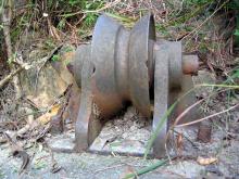
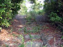
It is quite overgrown, but the main structures and pully system components intact. Visible ammunition storage pens on the sides of the battery. The pully ramp leads eventually to a private residence barbed wire fence. It is possible to bushwack around this fence and get to a lower one. But we still had to effectively break into a private residence to get out.
http://gwulo.com/atom/24980
Blurry Ramp- http://gwulo.com/atom/24979
great view- http://gwulo.com/atom/24981
Cheers
1st link doesnt work for me
1st link doesnt work for me btw. Copy and paste into the browser did though for anyone who needs it.
New Route Up
Went up again this past week. The maintenance trail has been removed but there is still a path left behind. Follow my above instructions to access the route. Basically, take a right onto Deep Water Bay Road (from Shouson Hill Road East) at the junction of the two roads. Round the corner and you should come to this view..
https://www.google.com/maps/@22.2479508,114.1841306,3a,75y,207.54h,77.05t/data=!3m7!1e1!3m5!1sQOTyL4IGqFiqsY07MKROvw!2e0!6s%2F%2Fgeo1.ggpht.com%2Fcbk%3Fpanoid%3DQOTyL4IGqFiqsY07MKROvw%26output%3Dthumbnail%26cb_client%3Dmaps_sv.tactile.gps%26thumb%3D2%26w%3D203%26h%3D100%26yaw%3D220.52087%26pitch%3D0%26thumbfov%3D100!7i16384!8i8192
At that right hand side where the lampost is (before the private road), there is a faint trail that leads off in the back of the bushes. It is a scramble at first, but the rest of the trail has ropes and is marked with ribbons. Leads all the way up, great views too!
latest status
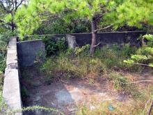
Can anyone read all the words on the wall?
Yesterday, I went there just the other way round, ie, from a dried up stream/small gully near Ming Villa, then down to 66 Deep Water Bay Rd, street lamp #33393.
Coordinates of the box in the west:
22.2473766, 114.1917863
I have been there few days
I have been there few days ago. Please see my video:
https://youtu.be/5PeTs2ibCJI
About the words on wall, I can tell:
1st roll "NATION SHALL NOT RISE..."
2rd roll "...LEARN..."
the rest can't recogize.
I may go there again in drier
I may go there again in drier season, the heavy rain these days have discouraged me.
Did you go there from Ming Villa or 66 DWB Rd?