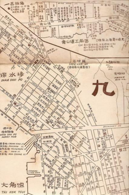
This map reminds me of the extent of my exploration and shoreline then... the ferry dock on Tung Chau St,, playing soccer at the end of Cheung Sha Wan Road at Yen Chow St where a gate stood. Beyond Berwick St was the start of the Shek Kip Mei shanty town. Somewhere I saw a photo of the Pei Ho street sign (I believe at Berwick) showing the aftermath of the 1953 fire on one side and on the other side the unaffected buildings. It also shows the locations of the theatres operating at that time.
This map is actually part of a large wall map of Kowloon. As info on the Web, this is likely a reprint of a map in 1958, first published about 1956. For example, I find that it is more descriptive of the terrain of King's Park and Homantin resettlement areas than the other published '1956 Kowloon' map (link).
The cartographer of the map may have some ties with Malaysia, romanisation of his Chinese name is quite special. A map of Malaysia by him is notable work of the time, see here.
On the Web, high-resolution images of this map could still be found, e.g. on 'Historical Time and Space', 2019. It could be useful to some studies of Kowloon for that decade.
It is heard that Castle Peak Road was full of factories during the 50s. But there may have been no ready illustration known from the documents. One interesting inset shows the factories area along Castle Peak Road (top portion of above map). As a trial, a vibrant mix of factories in post-war 50s could be traced as mapped along the street, with their company names in Chinese :
Comments
This map reminds me of the
This map reminds me of the extent of my exploration and shoreline then... the ferry dock on Tung Chau St,, playing soccer at the end of Cheung Sha Wan Road at Yen Chow St where a gate stood. Beyond Berwick St was the start of the Shek Kip Mei shanty town. Somewhere I saw a photo of the Pei Ho street sign (I believe at Berwick) showing the aftermath of the 1953 fire on one side and on the other side the unaffected buildings. It also shows the locations of the theatres operating at that time.
a resourceful wall map of the 1950s
This map is actually part of a large wall map of Kowloon. As info on the Web, this is likely a reprint of a map in 1958, first published about 1956.
For example, I find that it is more descriptive of the terrain of King's Park and Homantin resettlement areas than the other published '1956 Kowloon' map (link).
The cartographer of the map may have some ties with Malaysia, romanisation of his Chinese name is quite special. A map of Malaysia by him is notable
work of the time, see here.
On the Web, high-resolution images of this map could still be found, e.g. on 'Historical Time and Space', 2019. It could be useful to some studies
of Kowloon for that decade.
It is heard that Castle Peak Road was full of factories during the 50s. But there may have been no ready illustration known from the documents.
One interesting inset shows the factories area along Castle Peak Road (top portion of above map). As a trial, a vibrant mix of factories in
post-war 50s could be traced as mapped along the street, with their company names in Chinese :
(463 to 467) gourmet powder factory 泰豐
473 enamel factory 益豐
lot 3516 textile factory 香港
505 soft drink factory 東亞
500 steel windows factory 廣州
530 preserved fruits factory 李善記(*)
538 534 metal products factory 震亞
550 candied ginger factory 時新
588(to 592) textile factory 棉藝
608 enamel factory 香港
650 metal products factory 鼎大
(680) paint factory 香港
(#) watch case factory 德明
One picture worths a thousand words.
(*) handwritten error on the map. corrected
# street no. unknown