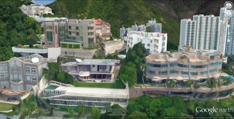
I thought you might be interested to know that Google Earth has now applied 3D rendering over much of the city. It's not perfect but it's not bad either and may help give a little bit more life to some of the properties we have been looking at. For instance, this is a reasonable reproduction of Jennifer's 77 Repulse Bay Road.
It's not perfect but adds a little bit of context to photos - particularly as you can move in and out of 3 dimensions within Google Earth to explore the surroundings.

Thanks Phil, I hadn't heard
Thanks Phil, I hadn't heard of that before - very cool!
I found this description of how it's made:
Since 2006, we’ve had textured 3D buildings in Google Earth, and today we are excited to announce that we will begin adding 3D models to entire metropolitan areas to Google Earth on mobile devices. This is possible thanks to a combination of our new imagery rendering techniques and computer vision that let us automatically create 3D cityscapes, complete with buildings, terrain and even landscaping, from 45-degree aerial imagery.
I wonder if the 45-degree imagery has to be taken from plane / helicopter, or if satellite images are good enough?
Regards, David
Aerial Photos
"Google Maps' satellite view is a "top-down" view; most of the high-resolution imagery of cities is aerial photography taken from aircraft flying at 800 feet (240 m) to 1,500 feet (460 m), while most other imagery is from satellites."
So the 45degree shots are also aerial photos.
re: Aerial Photos
Thanks Alun, that makes sense.
This has got me thinking about the project to reconstruct a building from old photos that I talked about back in 2008: http://gwulo.com/hong-kong-lost-historic-buildings
I decided on the KCR terminus and tried to model it using Microsoft Photosynth, but it couldn't make a good connection between the photos I had.
The technique of using photos to build 3D objects is called photogrammetry, and a search on the internet points to VisualFSM (http://ccwu.me/vsfm/) as a good tool, with the added attraction that it is free to use.
7 years have passed since my first attempt, so I was hopeful it would work better. But it still struggles: there just aren't enough photos, and most of the photos I have are from the internet so not high-enough resolution.
One way it works well is to feed it stills from a video that moves past / around a subject, and have it build a 3D model from that.
Phil, any chance you've come across clips that pan arouund or past the old KCR terminus building?
Regards, David
nothing springs to mind at
nothing springs to mind at the moment David. At least nothing I have at home, but i seem to remember a shot in one of the I Spy episodes when Robert Culp and Bill Cosby are riding past it on a rickshaw - filmed from the bus terminus looking east. I'll see if I can remember which episode it was...
Thanks Phil, looking through
Thanks Phil, looking through the photos of the KCR building I got excited to see the Soldier of Fortune photo, then remembered it's just got a couple of still shots, no movement.
I'll see what I can do with the photos for now, and if anything recognisable appears then post a model up on the website.