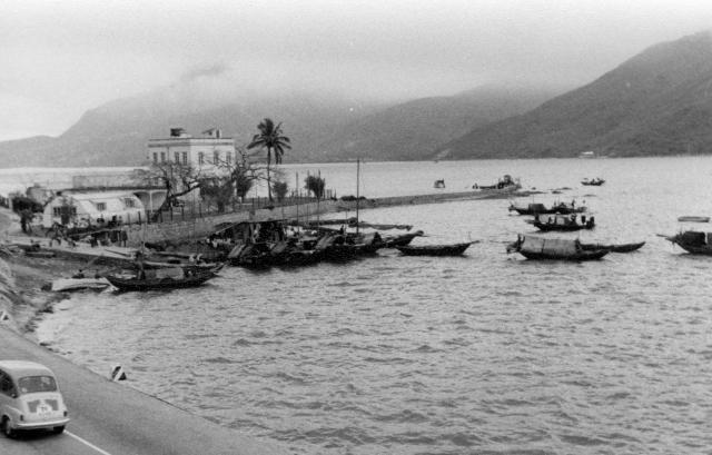
Sorry, Phil, I don't know as I didn't get off the train. However, zooming in on the photograph, it does look as though there is a jetty at the end of the spit of land with a boat that might well be a small ferry boat moored to it.
If it was indeed Lok Lo Ha, that particular building might as well be Ho Tung Lau. The shape of it looked very similar to the one in your movie blog. Mind looking that up to compare?
I don't think it matches, Thomas, the house above looks too small and is looks to be more box like. Ho Tung Lau had a large parapet on the top. I wonmder if the Lok Lo Ha ferry pier was right next to the village? I believe Ho Tung Lau stood where Block 6 of Jubilee Gardens stands now, which would put it some distance from the current village (about 250 metres).
Found this in Flickr, probably taken in another angle with Ho Tung Lau. The smaller house obscured by the trees appeared to be the one shown above. No Jetty in the photo though.
It could be, Thomas, but I'm not convinced just yet. If David's map above shows the bit of land/jetty, then that would put the photo north of the village, whereas Ho Tung Lau was south of the village.
I'm interested to read your comments and, perhaps to add anoher twist to your debate, what about the Nissen hut? There's also another single storey building part of which is just visible behind the Nissen hut. I'm also intrigued by the flat roofed building with two (possibly of three or four) arches visible at ground level and what looks like a fence round the top. The fairly compact cluster of buildings looks rather like some of the small military units that I have seen in past years in the U.K. Is there a possibility that the Royal Navy maintained a small unit there to accommodate the patrols that they must have carried out in Tolo Harbour? There is a fairly high fence round those buildings and the jetty is a substantial concrete structure, perhaps not what I would associate with a small ferry operation. Maybe this is a flight of fancy!
It could be a Marine Police post. I know there was one further up the coast at the Tai Po Kau pier, but perhaps this was a precursor or additional base?
Hi Folks, your discusions got me interested. Was this photo taken shortly after the train left Shatin station north bound? If so, the open water suggests the train has travelled past the mouth of the Shing Mun River. The 360-view on Google north of the Ma Liu Shui Waterfront Public Toilet shows the outline of the near- and distant hills similar to those shown here but not enough details to strongly support this conclusion. By comparing the two lines of sight, I suggest this was taken from the train (as Andrew already said) due west from the current Marine Police Waters District which now sits on reclaimed land.
One factor casts doubt on my estimate. The alignment of the rail track next to the spit on Dave's map has a mild curvature. I have difficulty matching this feature on the current air photo. Has the track been relocated to accommondate new developments?
Replying both to Old Timer and Moddsey. With a snapshot, as this was, I was just trying to capture something that looked unusual to me. As far as I can recall, the train was almost certainly North of Sha Tin but I cannot remember whether we had just left the station. The spit of land is certainly the same one, Lok Lo Ha, as on both my photograph and Moddsey's post card. My memory is very accurate about locations in places like Tai Po Market and Cheung Chau, where I walked but, from moving vehicles or trains, it's less so.
It's very interesting to follow your discussions, and those of others, and I'm sorry that after 57 years I cannot be more precise about some places.
On Pagr 98 of the book " Clutural Relicand Heritage of Shatin" issued by the Shatin District Council in 2005 there is a very small black and white photo showing the Ho Tung Lau at Lok Lo Ha. With the aid of a magnifying lens I found the size of Ho Tung Lau was much larger than that box-like building in Andrew's picture. Its architectural style was also more elegant and with a prominent parapet at the top forming the third storey of the building.
Andrew's picture was taken from a train at a location north of ( i.e. outside) the old Shatin town.and railway station. I saw this structure still standing at the shoreline in late1960s in my train rides to Tai Po Market.
Hello Tai, and anyone else who has been interested in this conversation
I know that Tai is in Canada but those of David's readers who live in Hong Kong might be able to act on the following -
I've just realised that I have an excellent book, Hong Kong in OId Times (A collecion of Aerial Photos taken in 1964) that I bought in the Survey and Mapping Office of the Lands Department in December 2007. Its number is ISBN 962-567-185-4. This was an excellent purchase, costing only something like HK$120 - and I am annoyed with myself for not referring to it in this discussion and also concerning my phtographs taken around Aberdeen harbour in both 1958 and 1981. Locating exact places is much easier with these old aerial photographs! On page 118, one of the aerial photographs clearly shows this spit of land which was roughly 3000m to the North of the Shatin station. It also shows that between 1958 and 1964 an additional jetty had been built to the SW of the one on my photograph. It has what looks like a new rectangular building at the end (possibly a shelter for people awaiting a ferry?) The aerial photograph names a high ridge (Fo Tan) due West of the spit of land with Lok Lo Ha in a valley about half way between Fo Tan and the spit of land. With luck our Hong Kong friends will now be able to pin-point the exact location of this short spit of land on either Google Earth or a modern map using those two named places. On page 119 there is a small photograph of 'Ho Tung Lau at Sha Tin'. This building has a central two storey section with a flat roof, a single storey section on the left with a pitched roof and a verandah, and on the right it has a single storey section probably with a flat roof. It is definitely not an exact match of the building on my photograph, but as there is no date against it, it could be a much older photograph than mine. A tall Norfolk(?) Pine tree is on that image but is not on mine suggesting that the image in the book is a much earlier one. This seems likely as the Nissen huts on mine do not feature on the book image. As the book is subject to copyright, I obviously cannot scan the relevant pages for you but It might be possible for one of you in Hong Kong to buy a copy. As mine is the June 2007 edition, there might well be other editions showing different periods in Hong Kong's recent history. It's a truly fascinating book and well worth buying if any of you can find one. I've been checking out more of these aerial photographs and I see that I could have been much more specific with my own identifications in Aberdeen and posibly Tsim Sha Tsui if I'd thought to check them out in this book! Good hunting. Andrew
I do have a copy of the "Hong Kong in Old Times" but forgot to use it in locating the Ho Tung Lau. Are you aware that there are ten errata in this book found by the users. In Sep 2007 three months after its publication the Lands Department announced the errata through a press release. Have you amended the errors in your copy ? If not please tell me and I will list them in a follow-up mail.
I do have a copy of the "Hong Kong in Old Times" but forgot to use it in locating the Ho Tung Lau. Are you aware that there are ten errata in this book found by the users. In Sep 2007 three months after its publication the Lands Department announced the errata through a press release. Have you amended the errors in your copy ? If not please tell me and I will list them in a follow-up mail.
You are right in saying that the Ho Tung Lau located further south to the structure shown on Andrew's photo. In the aerial photo on Page 118 of "Hong Kong in Old Times" there was a large piece of rectangular land runing south to north lying to the east of the railway tracks and Tai Po Road on the shoreline off the Wo Liu Hang Village at Fo Tan further south of the spit of land of Lok Lo Ha. Its size seems to match the description of Ho Tung Lau on Page 98 of "The Cultural Relic and Heritage of Shatin" published by the Shatin District Council in 2005. This book said that " Sir Ho Tung possessed over 20,000 sq feet of land near the shoreline of the current Fo Tan Railway Station on which he built a three-storey villa."
With the help a magnifying lens I found this piece of rectangular land has the following features : 1. In the northern end there are two large buildings. The one on the extreme north is smaller than the one next to it further south. The latter appears to be the main building of the HO Tung Lau villa. The relative position and size of these two buildings match those of the two buildings shown in the Robert Mitchum's movie in one of the links you mentioned. 2. In the centre there appears to be two tennis courts in an inverted L shape ( with the shorter " - "side at the top and pointing to the left ). 3. To the west and the south of the tennis courts is a large lawn. 4. In the southern extreme there is another building which apperas to be the living quarter of the domestic helpers.
I did not know about the ten errata, so I'd be grateful if you would let me know what they are. Those aerial photographs are quite fascinating for me as the Hong Kong that I knew in 1958 hadn't changed very much between then and 1964.
I just uploaded a 1974 picture to gwulo.com under the title " 1974Shatin". It shows the Ho Tung Lau viewed from the Tolo Cove in 1974. The layout and position of the structures in this picture matched the descriptions of the main buildings, tennis courts and servant living quarter on that large piece of rectangular land that I mentioned in my last comment. I will send you the ten errata tomorrow.
Thank you for sending the amendments. As I don't want to alter the book itself, I shall place what you sent into the front of my copy. Have the Lands Department people produced similar books covering earlier years? Some years ago I bought from the North Point office several copies of the excellent aerial photographs taken by the Royal Air Force in 1945 and/or 1949. I suspect that their archive probably has many more going back to the 1930s.
Since 2007 the Survey and Mapping Office of Lands Department published two aerial photo books :
1. In July 2011 the 112-page "City Under the Blue Sky - A Collection of Hong Kong Photos" was published at the price of HK$ 105.00. It mainly shows recent oblique aerial photos of Hong Kong.
2. In February 2014 the 160-page "Hong Kong Now and Then - A Collection of Hong Kong Aerial Photos" was released at the price of HK$ 210.00. It uses recent and old aerial photos to show the changes in Hong Kong since 1950's.
You may go to the home page of the Lands Department website (www.landsd.gov.hk) and enter the titles of these two publications to look for their sample photos. You may enquire the online order details by emailing smosale1@landsd.gov.hk.
Thanks for the information. I have several books containing aerial photographs taken at an oblique angle and see that the ones you mention are broadly similar. What I really enjoy doing is exploring the detail so often available on the old style vertical images such as the R.A.F. took and which were often the basis for the excellent maps produced by the Ordnance Survey. Perhaps, one day, another book of older vertical photographs will be published. I hope so.
Comments
Lok Lo Ha?
I wonder if this was where the ferry would leave from Lok Lo Ha to cross the harbour?
Sorry, Phil, I don't know as
Sorry, Phil, I don't know as I didn't get off the train. However, zooming in on the photograph, it does look as though there is a jetty at the end of the spit of land with a boat that might well be a small ferry boat moored to it.
Re: Lok Lo Ha?
Hi Phil,
If it was indeed Lok Lo Ha, that particular building might as well be Ho Tung Lau. The shape of it looked very similar to the one in your movie blog. Mind looking that up to compare?
T
Ho Tung Lau
I don't think it matches, Thomas, the house above looks too small and is looks to be more box like. Ho Tung Lau had a large parapet on the top. I wonmder if the Lok Lo Ha ferry pier was right next to the village? I believe Ho Tung Lau stood where Block 6 of Jubilee Gardens stands now, which would put it some distance from the current village (about 250 metres).
The spit is just visible on
The spit is just visible on this 1924 map, a short distance northeast from the village:
Re: Lok Lo Ha...
Hi Phil,
Found this in Flickr, probably taken in another angle with Ho Tung Lau. The smaller house obscured by the trees appeared to be the one shown above. No Jetty in the photo though.
T
It could be, Thomas, but I'm
It could be, Thomas, but I'm not convinced just yet. If David's map above shows the bit of land/jetty, then that would put the photo north of the village, whereas Ho Tung Lau was south of the village.
Cheers
Phil
I'm interested to read your
I'm interested to read your comments and, perhaps to add anoher twist to your debate, what about the Nissen hut? There's also another single storey building part of which is just visible behind the Nissen hut. I'm also intrigued by the flat roofed building with two (possibly of three or four) arches visible at ground level and what looks like a fence round the top. The fairly compact cluster of buildings looks rather like some of the small military units that I have seen in past years in the U.K. Is there a possibility that the Royal Navy maintained a small unit there to accommodate the patrols that they must have carried out in Tolo Harbour? There is a fairly high fence round those buildings and the jetty is a substantial concrete structure, perhaps not what I would associate with a small ferry operation. Maybe this is a flight of fancy!
Andrew
Marine Police?
It could be a Marine Police post. I know there was one further up the coast at the Tai Po Kau pier, but perhaps this was a precursor or additional base?
If this line is worth
If this line is worth following I'd agree that it's more likely to have been a Marine Police post than a Royal Navy one. Andrew
New Territories
Hi Folks, your discusions got me interested. Was this photo taken shortly after the train left Shatin station north bound? If so, the open water suggests the train has travelled past the mouth of the Shing Mun River. The 360-view on Google north of the Ma Liu Shui Waterfront Public Toilet shows the outline of the near- and distant hills similar to those shown here but not enough details to strongly support this conclusion. By comparing the two lines of sight, I suggest this was taken from the train (as Andrew already said) due west from the current Marine Police Waters District which now sits on reclaimed land.
One factor casts doubt on my estimate. The alignment of the rail track next to the spit on Dave's map has a mild curvature. I have difficulty matching this feature on the current air photo. Has the track been relocated to accommondate new developments?
Peter
1920s Lok Lo Ha, Sha Tin
Postcard of Lok Lo Ha, Sha Tin.
Replying both to Old Timer
Replying both to Old Timer and Moddsey. With a snapshot, as this was, I was just trying to capture something that looked unusual to me. As far as I can recall, the train was almost certainly North of Sha Tin but I cannot remember whether we had just left the station. The spit of land is certainly the same one, Lok Lo Ha, as on both my photograph and Moddsey's post card. My memory is very accurate about locations in places like Tai Po Market and Cheung Chau, where I walked but, from moving vehicles or trains, it's less so.
It's very interesting to follow your discussions, and those of others, and I'm sorry that after 57 years I cannot be more precise about some places.
Andrew
Ho Tung Lau at Lok Lo Ha
On Pagr 98 of the book " Clutural Relicand Heritage of Shatin" issued by the Shatin District Council in 2005 there is a very small black and white photo showing the Ho Tung Lau at Lok Lo Ha. With the aid of a magnifying lens I found the size of Ho Tung Lau was much larger than that box-like building in Andrew's picture. Its architectural style was also more elegant and with a prominent parapet at the top forming the third storey of the building.
Andrew's picture was taken from a train at a location north of ( i.e. outside) the old Shatin town.and railway station. I saw this structure still standing at the shoreline in late1960s in my train rides to Tai Po Market.
Tai Wong , Mississauga,Canada
Hello Tai, and anyone else
Hello Tai, and anyone else who has been interested in this conversation
I know that Tai is in Canada but those of David's readers who live in Hong Kong might be able to act on the following -
I've just realised that I have an excellent book, Hong Kong in OId Times (A collecion of Aerial Photos taken in 1964) that I bought in the Survey and Mapping Office of the Lands Department in December 2007. Its number is ISBN 962-567-185-4. This was an excellent purchase, costing only something like HK$120 - and I am annoyed with myself for not referring to it in this discussion and also concerning my phtographs taken around Aberdeen harbour in both 1958 and 1981. Locating exact places is much easier with these old aerial photographs! On page 118, one of the aerial photographs clearly shows this spit of land which was roughly 3000m to the North of the Shatin station. It also shows that between 1958 and 1964 an additional jetty had been built to the SW of the one on my photograph. It has what looks like a new rectangular building at the end (possibly a shelter for people awaiting a ferry?) The aerial photograph names a high ridge (Fo Tan) due West of the spit of land with Lok Lo Ha in a valley about half way between Fo Tan and the spit of land. With luck our Hong Kong friends will now be able to pin-point the exact location of this short spit of land on either Google Earth or a modern map using those two named places. On page 119 there is a small photograph of 'Ho Tung Lau at Sha Tin'. This building has a central two storey section with a flat roof, a single storey section on the left with a pitched roof and a verandah, and on the right it has a single storey section probably with a flat roof. It is definitely not an exact match of the building on my photograph, but as there is no date against it, it could be a much older photograph than mine. A tall Norfolk(?) Pine tree is on that image but is not on mine suggesting that the image in the book is a much earlier one. This seems likely as the Nissen huts on mine do not feature on the book image. As the book is subject to copyright, I obviously cannot scan the relevant pages for you but It might be possible for one of you in Hong Kong to buy a copy. As mine is the June 2007 edition, there might well be other editions showing different periods in Hong Kong's recent history. It's a truly fascinating book and well worth buying if any of you can find one. I've been checking out more of these aerial photographs and I see that I could have been much more specific with my own identifications in Aberdeen and posibly Tsim Sha Tsui if I'd thought to check them out in this book! Good hunting. Andrew
Locations
Here are the locations for the pier near Lok Lo Ha (that I think we're looking at in this photo): http://gwulo.com/node/28449
And for Ho Tung Lau, further south: http://gwulo.com/node/28741
Regards, David
Errata of "Hong Kong in Old Times"
Hello Andrew,
I do have a copy of the "Hong Kong in Old Times" but forgot to use it in locating the Ho Tung Lau. Are you aware that there are ten errata in this book found by the users. In Sep 2007 three months after its publication the Lands Department announced the errata through a press release. Have you amended the errors in your copy ? If not please tell me and I will list them in a follow-up mail.
Regards,
Tai Wong, Mississauga, Canada
Exact Location of Ho Tung Lau
Hello David,
You are right in saying that the Ho Tung Lau located further south to the structure shown on Andrew's photo. In the aerial photo on Page 118 of "Hong Kong in Old Times" there was a large piece of rectangular land runing south to north lying to the east of the railway tracks and Tai Po Road on the shoreline off the Wo Liu Hang Village at Fo Tan further south of the spit of land of Lok Lo Ha. Its size seems to match the description of Ho Tung Lau on Page 98 of "The Cultural Relic and Heritage of Shatin" published by the Shatin District Council in 2005. This book said that " Sir Ho Tung possessed over 20,000 sq feet of land near the shoreline of the current Fo Tan Railway Station on which he built a three-storey villa."
With the help a magnifying lens I found this piece of rectangular land has the following features : 1. In the northern end there are two large buildings. The one on the extreme north is smaller than the one next to it further south. The latter appears to be the main building of the HO Tung Lau villa. The relative position and size of these two buildings match those of the two buildings shown in the Robert Mitchum's movie in one of the links you mentioned. 2. In the centre there appears to be two tennis courts in an inverted L shape ( with the shorter " - "side at the top and pointing to the left ). 3. To the west and the south of the tennis courts is a large lawn. 4. In the southern extreme there is another building which apperas to be the living quarter of the domestic helpers.
With regards
Tai Wong
Hello Tai Wong
Hello Tai Wong
I did not know about the ten errata, so I'd be grateful if you would let me know what they are. Those aerial photographs are quite fascinating for me as the Hong Kong that I knew in 1958 hadn't changed very much between then and 1964.
Best wishes, Andrew
Picture of Ho Tung Lau
Dear Andrew,
I just uploaded a 1974 picture to gwulo.com under the title " 1974Shatin". It shows the Ho Tung Lau viewed from the Tolo Cove in 1974. The layout and position of the structures in this picture matched the descriptions of the main buildings, tennis courts and servant living quarter on that large piece of rectangular land that I mentioned in my last comment. I will send you the ten errata tomorrow.
Tai Wong
Errata of "Hong Kong in Old Times"
Dear Andrew,
Amendments of the ten errata in the "Hong Kong in Old Times" were released by the Lands Department on 27th September 2007.
1. Page 33 the year 2002 in the caption of the lower right picture should be 1999.
2. Page 35 the year 2002 in the caption of the lower right picture should be 2006.
3. Page 63 the words "St. Theresa's Hospital" in the upper left picture should read " Existing site of St. Theresa's Hospital".
4. Page 89 the caption of the upper right picture should read "Yau Tong in 1998".
5. Page 89 the caption of the lower right picture should read "Yaumati in Late 1950's."
6. Page 91 the year 1998 in the caption of the lower left picture should be 2002.
7. Page 109 the year 1985 in the caption of the upper right picture should be 1981.
8. Page 135 the caption of the upper right picture should read "Kwu Tung and Long Valley in 2004".
9. Page 159 the caption of the lower right picture should read "Chung Uk Tsuen in 2002".
10. Page 163 the year 1987 in the caption of the upper right picture should be 2002.
With regards.
Tai Wong
Errata in 'Hong Kong in Old Times'
Dear Tai
Thank you for sending the amendments. As I don't want to alter the book itself, I shall place what you sent into the front of my copy. Have the Lands Department people produced similar books covering earlier years? Some years ago I bought from the North Point office several copies of the excellent aerial photographs taken by the Royal Air Force in 1945 and/or 1949. I suspect that their archive probably has many more going back to the 1930s.
Best wishes
Andrew
Aerial Photo Books Published By Lands Department of Hong Kong
Hello Andrew,
Since 2007 the Survey and Mapping Office of Lands Department published two aerial photo books :
1. In July 2011 the 112-page "City Under the Blue Sky - A Collection of Hong Kong Photos" was published at the price of HK$ 105.00. It mainly shows recent oblique aerial photos of Hong Kong.
2. In February 2014 the 160-page "Hong Kong Now and Then - A Collection of Hong Kong Aerial Photos" was released at the price of HK$ 210.00. It uses recent and old aerial photos to show the changes in Hong Kong since 1950's.
You may go to the home page of the Lands Department website (www.landsd.gov.hk) and enter the titles of these two publications to look for their sample photos. You may enquire the online order details by emailing smosale1@landsd.gov.hk.
With regards
Tai Wong
Dear Tai
Dear Tai
Thanks for the information. I have several books containing aerial photographs taken at an oblique angle and see that the ones you mention are broadly similar. What I really enjoy doing is exploring the detail so often available on the old style vertical images such as the R.A.F. took and which were often the basis for the excellent maps produced by the Ordnance Survey. Perhaps, one day, another book of older vertical photographs will be published. I hope so.
Best wishes
Andrew
Sha tin
Is this building near the train tracks?
Yes. My photograph at the…
Yes. My photograph at the top of this thread was taken from the train. Andrew