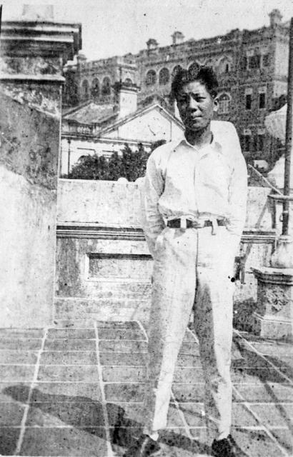
I don't recognise the big building, but it should stand out in some of the older views from the harbour. Try some of these to see if you can find a match:
I've made out that the triangular roof with the two chimneys right beside the man's head is the same as the one seen in the very back of the photo in https://gwulo.com/node/21187 but looking down on it. (The Caine Road/Ladder Street Photo). This roof is probably that of the neighbouring house. The large building behind is perhaps Wilderness or Craigengower English School or Dinder. The house names on the 1924 map don't match up to the 1901 map with house names (https://gwulo.com/node/7440) so I'm not sure of the correct ones. My photo was taken pretty much on the line of I.L. lot 573 and 574. I haven't been able to see the big building from the harbour views, though it should be just south of the synagogue. It probably isn't that imposing from a distance.
1. I believe Chris was correct about the location at where the photo was taken, namely No 145 Caine Road (modern numbering scheme, same as below).
2. In Chris’ photo, the triangular roof next to the man’s head was at No. 126 Caine Road.
The other triangular roof in https://gwulo.com/node/21187 was probably the top of the building at No. 33 Seymour Road, which appeared as the top row of “big buildings” above.
3. The “big buildings” probably consisted of two groups of buildings on Seymour Road. On the east (left in Chris’ photo) were No. 27 and 29, on the west were No. 31 and 33. There was a passage between the two groups. Thus part of the west facade of No. 29 could be seen in Chris’ photo.
4. The tiles in the photo can be used as a guide to the location of the background buildings.
With the assumption of square tiles and parallel to the facades of the building on which the photo was taken, the relative angles of 6 reference points of the background buildings could be estimated from the photo.
By drawing a set of lines with those angles, laying them on a map, it’s interesting to see they all pointed and matched well with features of some buildings, namely No. 126 Caine Road and No.27-33 Seymour Road as mentioned above.
No idea where exactly was this rooftop terrace was located but do know that the rooftop that this young fellow standing on is orangy-red like bricks although these flat roof was not cover by red bricks blocks but flat square-bricks? Sometimes one could find green algae moss like kind of growth on them....that was on a roof top similar to this one, on a roof top of a building that survivied Japanese if not Allies air raids during war time of the late 1930s to perhaps 1945-46? when HK was liberated from the Japanese? One way or the other, there were residents in the 1960s Kowloon Tong district on Kowloon side of Hong Kong, B.C.C. where we kids rode our tricycles on, had fun going through the wet bed sheets and laundries hanging on wires among errected metal pipes. Oh, this type of roof could be patched up with cement to close up the hole damaged by heavy "casing?", part of a small bomb used by the military's fighter planes if not bombmers....Excited to see a photo with a terracorta(flat brick colored) flat roof top similar to the one I used to chase pidgeons; watch the gardener tending pots of flowers besides laundries and sometimes, Chinese sausages etc. hung among the laundries!!!
Comments
I don't recognise the big
I don't recognise the big building, but it should stand out in some of the older views from the harbour. Try some of these to see if you can find a match:
https://gwulo.com/search/node/view%20from%20harbour%20type%3Aimage%2Cim…
Regards, David
Caine Road
I've made out that the triangular roof with the two chimneys right beside the man's head is the same as the one seen in the very back of the photo in https://gwulo.com/node/21187 but looking down on it. (The Caine Road/Ladder Street Photo). This roof is probably that of the neighbouring house. The large building behind is perhaps Wilderness or Craigengower English School or Dinder. The house names on the 1924 map don't match up to the 1901 map with house names (https://gwulo.com/node/7440) so I'm not sure of the correct ones. My photo was taken pretty much on the line of I.L. lot 573 and 574. I haven't been able to see the big building from the harbour views, though it should be just south of the synagogue. It probably isn't that imposing from a distance.
Re; Caine Road
From the harbour. A view of Caine Road commencing from Hop Yat Church.
No.27-31 Seymour Road from No.145 Caine Road
1. I believe Chris was correct about the location at where the photo was taken, namely No 145 Caine Road (modern numbering scheme, same as below).
2. In Chris’ photo, the triangular roof next to the man’s head was at No. 126 Caine Road.
The other triangular roof in https://gwulo.com/node/21187 was probably the top of the building at No. 33 Seymour Road, which appeared as the top row of “big buildings” above.
So the two roofs are not the same one as suggested. Both roofs appeared in https://gwulo.com/media/19872/zoom
3. The “big buildings” probably consisted of two groups of buildings on Seymour Road. On the east (left in Chris’ photo) were No. 27 and 29, on the west were No. 31 and 33. There was a passage between the two groups. Thus part of the west facade of No. 29 could be seen in Chris’ photo.
4. The tiles in the photo can be used as a guide to the location of the background buildings.
With the assumption of square tiles and parallel to the facades of the building on which the photo was taken, the relative angles of 6 reference points of the background buildings could be estimated from the photo.
By drawing a set of lines with those angles, laying them on a map, it’s interesting to see they all pointed and matched well with features of some buildings, namely No. 126 Caine Road and No.27-33 Seymour Road as mentioned above.
Rooftop terrace
No idea where exactly was this rooftop terrace was located but do know that the rooftop that this young fellow standing on is orangy-red like bricks although these flat roof was not cover by red bricks blocks but flat square-bricks? Sometimes one could find green algae moss like kind of growth on them....that was on a roof top similar to this one, on a roof top of a building that survivied Japanese if not Allies air raids during war time of the late 1930s to perhaps 1945-46? when HK was liberated from the Japanese? One way or the other, there were residents in the 1960s Kowloon Tong district on Kowloon side of Hong Kong, B.C.C. where we kids rode our tricycles on, had fun going through the wet bed sheets and laundries hanging on wires among errected metal pipes. Oh, this type of roof could be patched up with cement to close up the hole damaged by heavy "casing?", part of a small bomb used by the military's fighter planes if not bombmers....Excited to see a photo with a terracorta(flat brick colored) flat roof top similar to the one I used to chase pidgeons; watch the gardener tending pots of flowers besides laundries and sometimes, Chinese sausages etc. hung among the laundries!!!