I agree with David on the location. Other places that can be seen and serve to confirm the location are;
1. Lower left, the Aberdeen Reservoirs.
2. Middle left, the triangular shaped hill in silhouette is Mount Kellett with the War Memorial Hospital being the large building seen vaguely on the ridge just to its right.
3. The other summit, above and to the right of the hospital, is High West.
4. David has identified Peak Road. As it reaches the right side of the photo it comes to Magazine Gap out of sight behind the small hill between Magazine Gap and Wanchai Gap.
5. Further down the photo, Stubbs Road can be seen snaking around from Magazine Gap to Wanchai Gap.
6. Mount Cameron occupies the whole of the bottom right of the photo. The thin line that cuts across the corner is, I think, Black's Link.
The date given for the photo, 23rd December 1941, is significant. According to "Not the Slightest Chance" the Japanese ground advance reached Wanchai Gap that day. Specifically it notes;
"1330 hours ; Wanchai Gap and Magazine Gap are heavily dive-bombed."
With the Peak Road/Guildford Road junction identified by David being only a few hundred meters from Magazine Gap, the straight line of smoke sources running west from that junction may well be the result of this dive-bombing.
This is awesome! I have just finished writing up an update of my experience on that day in that very location. It was about 1:30 to 4:00 am on the 23rd that our group was withdrawing from Mount Cameron to Mt. Kellett area, together with the Winnipeg Grenadiers and the Royal Scots. On the night of Dec.22, we were under considerable shell fire as we were preparing to joined the military exodus, walking in the dark. The Japs were very close and within mortar range.The quality of the photo is not the greatest, but I wonder whether I can make a copy to add to my memoirs? What is the procedure, David?
Thanks for the confirming the location. I'm not sure about your point 5, as I don't think Stubbs Road will be visible if that thin line is Black's Link? There is one thick line that starts about 3/5 down on the right side of the photo, heading towards 8 o'clock. I think that might be damage to the negative rather than a road, as it gets very wiggly at its left end. I missed the War Memorial hospital, well spotted.
Bob,
You'll need to ask the person who uploaded it, IDJ. If he doesn't reply here, please send me a short email with your request and I'll forward it to him for you.
Comments
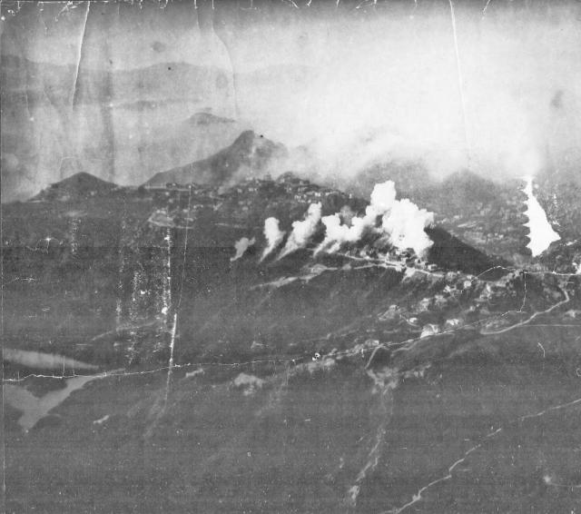
Is that Peak Road running
Is that Peak Road running through the columns of smoke? There's a road forking off from it and running downhill that could be Guildford Road.
Regards, David
Japanese Bombing Raid
I agree with David on the location. Other places that can be seen and serve to confirm the location are;
1. Lower left, the Aberdeen Reservoirs.
2. Middle left, the triangular shaped hill in silhouette is Mount Kellett with the War Memorial Hospital being the large building seen vaguely on the ridge just to its right.
3. The other summit, above and to the right of the hospital, is High West.
4. David has identified Peak Road. As it reaches the right side of the photo it comes to Magazine Gap out of sight behind the small hill between Magazine Gap and Wanchai Gap.
5. Further down the photo, Stubbs Road can be seen snaking around from Magazine Gap to Wanchai Gap.
6. Mount Cameron occupies the whole of the bottom right of the photo. The thin line that cuts across the corner is, I think, Black's Link.
The date given for the photo, 23rd December 1941, is significant. According to "Not the Slightest Chance" the Japanese ground advance reached Wanchai Gap that day. Specifically it notes;
"1330 hours ; Wanchai Gap and Magazine Gap are heavily dive-bombed."
With the Peak Road/Guildford Road junction identified by David being only a few hundred meters from Magazine Gap, the straight line of smoke sources running west from that junction may well be the result of this dive-bombing.
Japanese Bombing Raid
Here's a similar view taken from Mount Cameron a few months ago.
The Peak under Attack December 1941
This is awesome! I have just finished writing up an update of my experience on that day in that very location. It was about 1:30 to 4:00 am on the 23rd that our group was withdrawing from Mount Cameron to Mt. Kellett area, together with the Winnipeg Grenadiers and the Royal Scots. On the night of Dec.22, we were under considerable shell fire as we were preparing to joined the military exodus, walking in the dark. The Japs were very close and within mortar range.The quality of the photo is not the greatest, but I wonder whether I can make a copy to add to my memoirs? What is the procedure, David?
The Peak under attack
GW,
Thanks for the confirming the location. I'm not sure about your point 5, as I don't think Stubbs Road will be visible if that thin line is Black's Link? There is one thick line that starts about 3/5 down on the right side of the photo, heading towards 8 o'clock. I think that might be damage to the negative rather than a road, as it gets very wiggly at its left end. I missed the War Memorial hospital, well spotted.
Bob,
You'll need to ask the person who uploaded it, IDJ. If he doesn't reply here, please send me a short email with your request and I'll forward it to him for you.
Regards, David