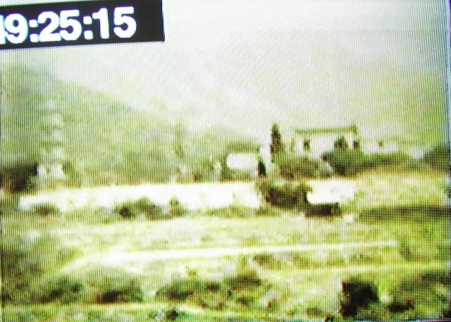
This is another "still" taken from an old 8mm film made in 1948.
It shows a pagoda, on a flattish terrain, it could be near the Kowloon hospital as the film shows the hospital shortly before. Or maybe somewhere in the New Territories?
Suziepie
Date picture taken
25 Feb 1948
Shows place(s)
Comments
Re: Chi Lin Nunnery
Hi moddsey and tngan,
Thanks for your input. I vaguely remember seeing a photo of the previous incarnation of Chi Lin Nunnery buildings, and they were not in classical Chinese style. However, I cannot find the photo online just now.
I am thinking the pagoda may be between Tai Po and Fan Ling. There are some Daoist temples in the area. Perhaps we need to consult the local Tai Po expert philk.
Another place, another time?
"A few hundred yards out in the fields near Sheung Shui village in the New Territories there is the concrete base of an old pagoda.
It was built many years ago to a height of about 30 feet and was sited by a geomancer.
Its purpose was to act as a ‘geomantic bird-table’. An outcrop of rock a mile or so away looked much like an open eagle’s beak (indeed, it still does), and it was thought that this was the cause of a marked failure of the inhabitants of the exposed part of the village to produce sons. If the pagoda were interposed, the eagle would eat off it and not destroy the reproductive powers of the villagers.
Well, after a fashion it worked. But at the same time it seemed to be having an incredibly good effect on another nearby village, which suddenly began to produce brilliant and precocious children in large numbers. Weighing up the pros and cons, the Sheung Shui people decided that they would rather put up with their former poor reproduction rate than see a rival village prosper.
So they tore down the pagoda again."
Extracted from:-"More Ancestral Images" by Dr Hugh Baker published by SCMP in 1980
No pictures or further clues as to what it looked like or a date when it was pulled down. Older Sheung Shui residents should know.
It has to be the Tsui Sing Lau Pagoda
Hi All
I have taken the full B/W photo and enlarged the Pagoda area - and put all 3 on the ssme page to compare. I have sent this "photopage" to David as I am not able to put this on Gwulo myself. Perhaps David you might be able to?
I am confident this is the same location. There are far too many similarities for it not to be:
I suspect the 8mm film was taken much further to the right. In which case the lower hill on the far left of the full B/W photo would equate to that in the 8mm frame. The mountains in the background are significantly similar. The distance between Pagoda and house are same. The long front wall would be more evident when viewed from an angle much further to the right - as said above. Both pictures show large tree/s near house. The terraces in front are not large and in the enlarged B/W photo they appear more evident. It would depend where the photographer was standing and how close he was to the pagoda. The closer the 8mm photographer was standing the less flat the area would appear.
Unless proved otherwise I am confident that this is - as David W says - the Tsui Sing Lau Pagoda. Nothing else makes sense. It is certainly not any kind of nunnery, and it is much taller than 30 feet! - and it definitely was there in 1948!
Suziepie
Pagoda success
More success.
During the morning of Tuesday 9th December 2014 I visited the Ping Shan Heritage Trail Visitors Centre. On arrival I roamed around the various buildings which contain rooms hosting a large selection of ancient and modern photographs together with other portraits connected with the local history.
One room contains a large blown up black and white copy of the 1945 aerial photograph found in the giveaway pamphlet, and adjacent to it is a very recent coloured aerial photograph of the area.
I eventually found my way to the Reception area and met Tracy, Winnie and Carol. After producing copies of the various photographs and other items drawings found in this forum topic, I then invited them to help me identify the following locations on the 1945 aerial photograph of Ping Shan:-
Today’s Visitors Centre, The ancestral halls, Sheung Cheung Wai Village, and The Tsui Sing Lau Pagoda.
“We” found the first two fairly quickly, but there was some confusion about the Sheung Cheung Wai village and a mark on the photograph which I thought was the pagoda. The latter two were out of kilter with each other. The girls had hearsay knowledge of the pagoda but could offer little to resolve the enquiry. Eventually I mentioned that I had seen a blown up photograph in another building so Carol accompanied me to the room concerned. We went through the same process again to identify the features mentioned above.
In a short time we were joined by Ah Fung, Ronald and Polly, so the word was getting around that a Gwai Lo was asking some very interesting questions. Once Ah Fung and Ronald had seen the various papers I had brought with me our joint effort was rewarded when Carol spotted the pagoda on the photograph.
It certainly is a pagoda and a large one as well. In fact it’s so tall that it casts a prominent sun shadow and the outline of its shape is also clear to see. After viewing the object for some time Ronald and I were of the opinion that the size of the shadow indicated that this must be the seven level pagoda.
I have since produced a new AutoCAD drawing based on the 1945 aerial photograph and indicated where the features are. I have also indicated with an arrow the area where the photographer was likely to be when he took the Super 8 film. What we don’t know is the magnification power of the camera lens – perhaps it was one of those types that had three selectable lenses.
Polly also produced a Chinese text document from the Internet that mentioned the pagoda was a seven level structure.
What we don’t know exactly is whether or not the missing four levels were removed on one or two occasions. The causation for removal is also unclear, but Ronald was of the opinion that four were removed in one go and the cause was probably deterioration of the upper structure for want of maintenance. In tandem with this there was no money for restoration.
What everybody does find strange is that there is no known photograph of the seven level pagoda in the Visitors Centre, nor on the Internet.
I am of the opinion that so much progress has been made in this search that the information pamphlet for the heritage trail could be re-written in good time for the next reprint. Perhaps Suziepie would like to offer/donate his/her pictures to the Leisure and Cultural Services Department (LCSD) for inclusion in a reprinted pamphlet.
I plan to write to the LCSD and offer a few suggestions one of which includes the annotation of the 1945 aerial photograph with the names of the important structures in the area and the location of the pagoda.
The staff deserve a well earned thank you because they found that a normal quiet day had suddenly become rather exciting.
For clarity, the more recent
For clarity, the more recent picture posted by Suziepie shows a much clearer image of the pagoda. Allowing for the height of the wall around the Sheung Cheung Wai village and the undulating nature of the land mass, the first observeable level of the pagoda may in fact be its second level. Change the counting logic and its possible to just discern seven levels
Suziepie if you enlarge the picture/drawing in the previous post you will see a black arrow line linking the pagoda and the corner of the Sheung Cheung Wai protection wall. Keep following the arrow line to the right and you will see that it crosses a prominent road/footpath. It is on that footpath that the Super 8 film was taken - no doubt about it.
Got anymore hard to solve problems?
Pagodas
IDJ, thanks for the extra pagoda information. Has anyone seen a photo of that pagoda?
Suziepie, if you upload the extra photos to Gwulo, I can add them to your comment above. We'll have to agree to disagree on the location of this one though, as I can't make the terraces match this flat land in my mind.
Dave W, thanks for the follow-up visits. That aerial photo is a good one. Your suggested line of sight is roughly north-facing. Wouldn't that put the open land (fish ponds etc) in the background, instead of hills? Regardless of which pagoda this photo shows, it will be good to confirm when the Tsui Sing Lau pagoda lost its upper levels. If you meet any villagers in their 80s, please can you ask how tall was the pagoda when they were children?
I'll keep a look out for other pagoda photos, especially any that were from the 1940s or earlier. (If anyone uploads a pagoda photo, please tag it pagoda to add it to the list: http://gwulo.com/taxonomy/term/993)
Regards, David
Admin
If the LCSD would allow it, I would like to place a straight edge on their blown up 1945 aerial photograph and from the pagoda shadows I could give Suziepie two points on the footpath, and, between these, would be the photographer's position - thereabouts.
I may ask the LCSD if they have any data on the aerial photograph, in particular the height the photographs were taken at. From that simple mathematics could be used to work out the pagoda height based on shadow length. It would not be absolute, but a pretty good indicator. Alternatively I could work on the measurements based on buildings still extant today.
I wonder if a museum or library in Gwongzhou has a picture of the pagoda?
My cantonese is not good enough for a question and answer session with the local residents.
Pagoda
here's why I am fairly certain this is not Tsui Sing Lau.
1. This looks like a 6 storey pagoda, You can just make a bottom tier out. Given that the current pagoda is 13 metres tall, this would make the pagoda in the picture about double that size and the building on the right would be somewhere between 15 to 20 metres in height depending on how far away it is, and to me it looks a bit further away from the camera. I'm no expert but I don't think you can find old buildings (of that style) that tall in the NT.
2. The apertures on the current pagoda face south which means this 8mm would be shot facing north. North of Ping Shan and the pagoda now is Tin Shui Wai which was built on reclaimed wetland and marsh. If this was the Tsui Sing Lau pagoda then that would mean several mountains of significant size would have to have been removed. I'm fairly certain this didn't happen. Yes, there are other sides with smaller apertures but they face SE/SW, you would still be looking northish even if the film shows one of these other sides.
3. That is not a wall from a walled village. Sheung Cheung Wai is not that near to the pagoda, and its wall is a protective wall of around 3 metres height. If the film picture white strip is a wall then it is a small garden wall, nothing more.
Here's another idea, but obviously one that can't be confirmed - I suspect that the damage to the pagoda has not happened in living memory, hence why no one can remember any dates. Surely damage from a typhoon would have been reported in papers and the information would be easily accessible - or villagers would remember and the information would have been found by whomever researched the materials for the museum? I've looked at about 5 reference books on the subject and none can provide a date - only this anecdotal information about it being damaged.
Anyway, I would love to be proven wrong about this because finding a picture of the pagoda in a previous form would be a great find.
A different point of many views
here's why I am fairly certain this is not Tsui Sing Lau.
1. This looks like a 6 storey pagoda, You can just make a bottom tier out.
We can make out a lower tier (level) but we don’t know which one it is. How do you know it’s the “bottom” tier? What do you mean by “bottom tier?” Remember my earlier comments above when I mentioned the unknown height of the village wall and the undulating ground levels which complicated the perspective?
Given that the current pagoda is 13 metres tall, this would make the pagoda in the picture about double that size and the building on the right would be somewhere between 15 to 20 metres in height depending on how far away it is, and to me it looks a bit further away from the camera. I'm no expert but I don't think you can find old buildings (of that style) that tall in the NT.
I don’t agree. We are dealing with perspective and depth of vision and a camera lens of unknown magnification. Having drawn the outlines in AutoCAD mentioned previously I mentioned a ratio between different levels. The ratio works in width and height so I would expect the seventh level to be rather small affair with a smallish roof above.
2. The apertures on the current pagoda face south which means this 8mm would be shot facing north. North of Ping Shan and the pagoda now is Tin Shui Wai which was built on reclaimed wetland and marsh. If this was the Tsui Sing Lau pagoda then that would mean several mountains of significant size would have to have been removed. I'm fairly certain this didn't happen. Yes, there are other sides with smaller apertures but they face SE/SW, you would still be looking north-ish even if the film shows one of these other sides.
Correct (filmed shot facing North), the 1945 aerial photograph also contains a NORTH arrow which I cropped from the picture for space purposes. I disagree with the term “mountains” and suggest that small hills or even mounds is more appropriate. Your general reference to North for the film direction is correct. But how far away are your “mountains?” This also baffles me, but I think I can work it out. At the moment I am sacrificing my time and efforts on factual events and matters – no supposition, guesswork, or gut feeling.
3. That is not a wall from a walled village. Sheung Cheung Wai is not that near to the pagoda, and its wall is a protective wall of around 3 metres height. If the film picture white strip is a wall then it is a small garden wall, nothing more.
Look more carefully. There is a significant distance from the village wall to the pagoda. Its perspective and depth of vision.
Here's another idea, but obviously one that can't be confirmed - I suspect that the damage to the pagoda has not happened in living memory, hence why no one can remember any dates.
I disagree. There probably never was any “damage” to the pagoda. It had reached a state where lack of good maintenance (no maintenance) rendered it into a dangerous state and the villagers knew this so the height was reduced. There was no money to maintain it.
If there are no glorious newspapers headlines to record a catastrophic partial structural collapse due to a typhoon then this was unlikely to be the cause. Everything is vague about the height of the structure being reduced. I too am surprised about the lack of detailed history, so, there must be a reason for it. How can Suziepie’s Super 8 film jump from Kowloon Hospital to this scene and the water buffalo’s et al? It’s because the film maker was taking film on an opportunist basis, as was done by anyone who owned a camera in those days. Even in my own lifetime I have had a camera where the film was developed weeks or even months after the first frame was taken.
I have no reason to doubt Suziepie’s film frame as being authentic and taken as I have described in the foregoing notes.
Surely damage from a typhoon would have been reported in papers and the information would be easily accessible - or villagers would remember and the information would have been found by whoever researched the materials for the museum?
Agreed, so why are there no reports of substance?
I've looked at about 5 reference books on the subject and none can provide a date - only this anecdotal information about it being damaged.
Please quote the five reference books and page numbers plus the current location and I will find time to take a look at them.
Anyway, I would love to be proven wrong about this because finding a picture of the pagoda in a previous form would be a great find.
Have you made a site visit and tackled (looked at) all the evidence I have put in this forum article?
Let’s look again. We have the three alignments as I call them:-
The pagoda #1
The walled village - #2
The position of the photographer - #3
We then have the corroboration evidence:-
Suziepie’s independent film.
The 1945 aerial photograph.
Interpretation:- Where on this earth can you so conveniently find the above mentioned co-incidences?
Look at the alignments (#) and see how they place the film taker on a very clear and well defined dirt track/ village road/ or footpath of some sort. Such coincidences cannot be easily invented.
Please go to the Ping Shan Heritage Trail Visitors Centre and look at the enlarged aerial photograph and study it very carefully.
We are obviously not in agreement with each other.
Now let me introduce some new thinking.
The latest test arises because there are some hills, mounds, mountains in the background.
The next clue comes from Suziepie who states that this is Super 8 film.
Now let’s consider the Super 8 film camera. We don’t know the make but it’s probably American - colour and very advanced for the ordinary punter at the time.
Is it electro/mechanical , or, clockwork, wind up if you like.
I know nothing about these cameras except to say that in 1969/70 when on the Vice Squad in Kowloon, Super 8 film blue movies were all over the place.
Let’s dig deeper into the mechanism of the camera. Is it (was it) possible for frames to blend together so that there was an image of the previous frames blended with the now, newly taken set of frames? A cross over if you like?
There must be few people alive who know of the workings of the Super 8 film camera and I wish they could be here to comment on what is being written in this topic.
What we are also not privy to is a continuous run of Suziepie’s film so we are all working in the dark.
So far we have seen freeze frames from Susiepie’s film but no continuous run. Readers may now begin to see what I am getting at.
Is there a transition causing an overlay of one film run moment to another which is causing all of us to believe what is not true. In other words, are the mounds, hills, mountains actually from somewhere else – a previous run of film - and not truly behind the pagoda and Sheung Cheung Wai village?
If the mechanism was clockwork was there a form of kick-back where the inertia of the motor or mechanism could cause an over recording?
Over to you Phil K.
Pagodas
Hi Dave,
You're sure it's Tsui Sing Lau, I'm sure it isn't - I doubt we'll change each others' mind by looking harder at the photos we've got.
I've been thinking what other sources would show how the Tsui Sing Lau pagoda looked like in the 1940s or earlier, as that would help settle the question.
The only reference book I have for that area is Patricia Lim's "Discovering Hong Kong's Cultural Heritage". It mentions the pagoda, but basically repeats the same story: "It is said to have originally had seven floors but, after the upper storeys twice collapsed, perhaps in typhoons, the geomancers agreed that it was better to leave it as it now stands." No dates for the change in height.
Photos? I've searched for pagoda in Images at the Public Library's MMIS. There are a few shots of Tsui Sing Lau pagoda, but the earliest is dated "ca. 1950s": https://mmis.hkpl.gov.hk/coverpage/-/coverpage/view?_coverpage_WAR_mmis…
Guide books? If there was a pre-war guidebook that described a visit to the Tsui Sing Lau pagoda, that might tell us it's height at the time. There's a book of hikes written in the 1930s whose name I can't remember, which might have something. A 1924 guidebook I have is very brief about anything past Kowloon, and doesn't mention the pagoda.
So it's a dead-end at the moment, but I'll add the question to the Tsui Sing Lau pagoda's page (http://gwulo.com/node/22435), and see what answers come in over time.
Regards, David
Your too obsessed
David,
No, don't be obsessed with the visual and circumstantial evidence.
Please explain why the pagoda at Ping Shan is only three tiers in height? Where do you go from this question?
My evidence and surrounding information is far better than yours.
David
Chill out, everyone
Folks,
Chill out, everone. No need to turn this into a fight.
I believe it is best to investigate the possibility of putting whole converted video onto Youtube for viewing. Viewing the whole thing might give more clues as the location of what had been covered in the three minutes (ltime limit for a super 8 cartridge) or so are likely close.
If it is on Youtube we could also ask the elders or other historians to take a look.
My 2 cents.
T
Pagoda - other resources?
Hello everyone,
Thanks to Dave for doing so much investigative work on the history of Tsui Sing Lau.
In terms of photographic evidence, I don't believe that no pre-war photo exists. I remember Mr, Sung Hok-Pang wrote some essays on the history of New Territories that appeared in Hong Kong Naturalists (?) in the 1930s, and were reprinted in the Journal of the HK Branch of Royal Asiatic Society in the 1970s. I wonder if the essays included some photos of Tsui Sing Lau.
My other wild ideas about the location of the mysterious pagoda include: Daoist temple in Tai Po, some sort of film studio, somewhere across the border in China.
Is it a good idea to post the pagoda photo on uwants.com? Some guys there are really good with identifying buildings and streets on photos. There are a couple of long threads about guessing where photos were taken.
Pagoda - other resources?
And I agree with tngan... Let's relax and have an open mind about it. Don't exclude possibilities unless there is hard evidence.
Sheung Cheung Wai village
This morning (Thursday) if all goes well, I am going to visit Sheung Cheung Wai village and have a good look around it.
So far this has not been subject to an on-site visit, so I shall be looking for the external wall, and any extant old building.
The land levels - if any are left - inside the village compound will also be of interest.
I shall report back later.
Suzipie, we need more answers from you. Can you tell us what subject matter appears on this Super 8 film in sequence. A to B to C and so on.
Are you replaying the film on a proper old Super 8 film projector, or doing it some other way? If its the latter how are you doing it?
Does the Super 8 film contain serrations (or square indents) to allow it to be cog fed through the projector mechanism?
Is the film being played the correct way round?
Could the film have been spliced - made up from other films?
Any other detail no matter how insignificant would be useful.
Another 7 storey pagoda in Yuen Long
Yuen Long hosts the Aviary Park 7 storey pagoda. The design seems vastly different from that in this forum debate.
http://www.ilovehongkong.org/yuen-long-park-new-territories-hong-kong/
Another avenue of enquiry
A PAGODA IN THE NEW TERRITORIS
Hi David W
Thank you so much for all the trouble you ar going to - I didn't realise when I uploaded the "still" how controversial it would be. I thought someone would know right away! In answer to your queries:
Quote: Can you tell us what subject matter appears on this Super 8 film in sequence. A to B to C and so on.
All the subject matter on this part is in Kowloon or NT. There is Kowloon Hospital (my brother was born the week this was taken - hence he was visiting the hospital and I guess touring around!). There is footage of I think the border - I will upload a couple of frames on either side.
Quote: Are you replaying the film on a proper old Super 8 film projector, or doing it some other way? If its the latter how are you doing it? Does the Super 8 film contain serrations (or square indents) to allow it to be cog fed through the projector mechanism? Is the film being played the correct way round? Could the film have been spliced - made up from other films?
As mentioned previously - so long ago you propably missed it - the 8mm film was transferred to video about 20 years ago. Now videos are becoming obsolete it has been put to DVD - I have a studio doing that for me - they have given me a temporary DVD with a running timer that you can see on the top left corner. This is so I can write down the time and any note that I want added. They will then do that for me. I want to put notes in the DVD so future generations will know who, where, what. Which is why I would like to get it right and not guess - which is why I put these pictures (stills) from the 8mm film on to Gwulo in the first place. The original 8mm film is long gone. And it IS the correct way round and this part of the film is not spliced.
Thanks again,
Suziepie
A Pagoda in New Territories 1948 - probably Tsui Sing Lau
I will upload a couple more 'stills' from either side of the pagoda ''still'
Suziepie
First of all let me apologise
First of all let me apologise for the obsessiveness comment/post. On reflection it’s me that has become obsessive in this very interesting search for “Where is it?” Old age, retirement, little to do, tend to act as stimulants to find a challenge which then become all consuming.
Philk and David your comments have been read with great interest. Of course philk’s comments make sense, they woke me up at 05.30hrs this morning. I have just been reading the Heritage Trail booklet again and it makes mention that the Tsui Sing Lau pagoda was originally built at the mouth of a river facing Deep Bay……………. Another part of the text reads “Its auspicious location in alignment with Castle Peak……………
With the aid of Google Earth’s ruler I have been drawing various lines to align the mouth of the river leading into Deep Bay with the pagoda and then beyond into the hinterland. To my surprise this appears to produce the picture that philk wants to see. There is a low hill to the left of the pagoda and in the distance what philk would call a mountain. To the right is a valley floor which is similar to that shown in Suzipie’s photograph. This is a rough approximation for the purposes of this short note.
Working back along the alignments mentioned above, it would seem that the ‘so called’ walled ‘compound/village/farmyard’ in Suzipie’s photograph could be under Tin Sin Sui Wai West Rail station or the housing estate further back.
This now takes Sheung Cheung Wai village out of the equation and means that I shall have to go and walk the ground. I shall also need to go begging in the Yuen Long District Lands Office to see what survey drawings they have before the area was developed.
Suzipie’s photograph also offers another option. Slap bang in the middle is a prominent structure which has width. I know it’s difficult to guess the width of a village house, or building used for other purposes, but a few inspired measurements could be used to roughly dimension the length of what appears to be a wall around a compound that may not be a village as such, but more of a farm facility with external buildings
The foregoing means that Google Earth can be used to roughly dimension Sheung Cheung Village, and I should then be able to compare the measurements. I think Sheung Cheung Village is a goner.
I am still intrigued with Suzipie’s photograph and the only thing that keeps me going back to the Tsui Sing Lau pagoda is the prominent corbel line at each level. The secondary factor is the number of levels that can be observed.
I shall carry on for another week and if the search throws up a load of negatives I shall retire from the venture.
The idea to put the cine film on YouTube is a very good one. Let’s hope that can be done because that may offer more clues.
I have attached an AutoCAD overlay with annotations to show you what I see on the photograph. Can you see anymore? I am beginning to see that the compound as I now call it must be infinitely bigger than the Sheung Cheung Wai village. It seems to be – and I am guessing – like a farmyard or some such thing.
Chinese residential villages never disappear, many are with us today. Try getting rid of one! But farm land is a different kettle of fish. Look how much has been eaten up to make way for new roads, railways and new towns.
This mystery will not be solved by the Internet alone. Hopefully it will be solved with the Internet, Google Earth, Lands Office survey maps, walking over the ground, and the skylines for the hills.
Please add a comment, I am running out of ideas.
An old map of around early 1980s of Ping Shan area
Folks,
I have an old map booklet with a page or two of the area in question. I'll have to check again for the publishing date. Please take a look. https://app.box.com/s/tr533rv5hem4gc4uggnv
Thanks & Best Regards,
T
Optomistic
Mid-morning today – Friday 12th December 2014 – I had a need to travel from Yuen Long to Tuen Mun so I took the West Rail.
I took with me all the photographs that have been placed in this forum topic so far.
Down to Tin Shui Wai I studied the latest photograph which I posted earlier this morning.
After exiting Tin Shui Wai Station the track curves around to the right. In a matter of moments I could see two descending skylines – high left to descending to low right – just as in Suzipie’s photographs. Owing to the constantly curving track and the acceleration of the train there was a moment when I thought I could see a knoll on the furthest skyline that would match with the photograph.
I have since become rather optimistic and excited.
I have no free time this weekend, but on Monday I propose to take my daughter’s camera and spend an hour, or as much time as is needed, to walk around and see what I can line up. There will be problems due to the position of the Tin Siu Wai station and perhaps new high rise structures so I will do my best.
Philk and David thank you very much for disagreeing with my earlier thoughts because this new approach changes things completely.
Please look out for a new forum note next week.
A PAGODA IN THE NEW TERRITORIS
Hi Dave - and all
Thank you Dave for all your trying!! I am amazed when you said you were retired - with all the energy I've seen you put into this I thought you were a young man!
Uwants
C, if you're active on Uwants by all means post a copy there. You can download a copy from:
http://gwulo.com/sites/gwulo.com/files/thumbnails/image/Pagoda.jpg
It'll be good to get some other opinions, and as you say they are very skilled at identifying photos.
Regards, David
TNgan,
TNgan,
Thank you very much for your contribution with the survey map extract.
The pagoda is straight forward to find, but what is priceless is the detail of the Ping Ha Road alignment and its branch off roads. I have red arrowed an approximation where I think the cine film was taken from.
Also interesting is to look at the red lines pointing down to yonder hill sides – and more importantly the downhill running natural stream/run off gulley’s because these can be observed on Suzipie’s photograph. I have marked them on the mixed AutoCAD/Suzipie photograph placed on the Forum this morning.
The survey map does not lend itself to good perspective over distance but I think what we are seeing is the Yuen Long to Ping Shan, to Castle Peak, to Tuen Mun Valley – it has a curve on it.
Press on.
Final arbiter ?
Just a thought, but who will be the final arbiter to declare that this pagoda is, or is not, the Tsui Sing Lau pagoda?
Yes, I'm old Suzipie
Suziepie.
My pen picture - if David does not mind.
British, 66 going on 67 years. Full mop of hair, missing front tooth = French bread, came to HK on 21st February 1969, still here, married a local Chinese girl, daughter 30+ native English teacher.
Hobbies: early years, China Sea races on the schooner Mandalay. I was fore-deck crew, gunner, engineer, and assistant cook. Have visited most reefs in the South China Sea. The best is Scarborough Reef, though Pratas Reef has a fascinating history.
Latter day hobbies – I like cooking. Lately, have spent the last 17 years designing and building bit by bit, piece by piece, Hong Kong’s best combined BBQ/Roasting Spit. All stainless steel and designed to last 100 years plus with a good owner. I make what I can with my own hands, but lathe and milling work I get done by an engineer in Tuen Mun. Isambard Kingdom Brunel would give it the thumbs up. Have previously cooked at least three full grown pigs and one sheep. Whichever, you need a big party of at least 60 people for a fully grown pig.
My favourite cooking specialties are traditional English Sunday roasts on my roasting spit: Roast pork loin with the skin on and pared for crackling, roast potatoes, mashed potatoes, apple sauce, medium thick gravy, seasonal vegetables. Same thing for roast beef and Yorkshire pudding. Have no trouble inviting guests. The last one I held a few months ago included retired Hong Kong Police friends and their wives. My daughter did an audit the following day to see what had been drunk – guests two bottles of wine each and I don’t drink wine except for Rose which is a rare event. As my daughter rarely drinks she provides a ‘taxi’ home service if the guests reside nearby. The meats come from Henry’s Delicatessen in Tseung Kwan O – an old friend – Danish - who supplies many hotels in Hong Kong with quality meats.
Other hobbies engineering related; designed and built my own solar hot water heater system – in daily use and saves many dollars on the electricity bill throughout the year. Have also built my own renewable energy system which includes wind turbines and a photo-voltaic panel unit which automatically tracks the sun from rise to sunset.
Latest foray - challenges on Gwulo.
Next: fine finishes to the BBQ/Roasting spit – buffing and polishing the stainless steel to draw out the gleam and shine.
1936 Ping Shan
Yes, it would be nice to determine if the pagoda in the screen capture is indeed from Tsui Sing Lau. For comparison, a map of the area from 1936 from HKPL. Please note some areas in the vicinity of Ping Shan were flattened for the proposed airport at Ping Shan in 1945/1946. The scheme was abandoned in 1946. Castle Peak Road runs through Ping Shan near the Police Station.
Re: Pagoda in the picture
Hi there,
I would like to throw in a bit of curiosity and uncertainty into the mix.
I went to Ping Shang to refresh my bearings earlier today I went to the Ping Shan Tang Clan Gallery and bumped into a guideed tour there. I pretend to be part of the group and tag along. The tour was a short one. The volunteer docent mumbles his way through the exhibits. He did mention the Pagoda as purely Feng Shui structure built by the Tang Clan long time ago. However they did not keep any records of when did it become what we see today.
He mentioned when he prepare for his notes he asked the village elders about the pagoda of its origins and legends but no one could pin point when it become three storeys. One of the elders only said some sixty-seventy years ago when he was a kit, the pagoda was already like that.
Suzie mentioned the film was converted into video around 20 years ago. I wonder when was the original film was shot. If it was post WWII and if the village elder was right about his memory, the image capture would be in conflict.
On the other hand, when I was on-site, I was unable to find any slopes so steep behind the Pagoda in any direction.
My opinion is, it is inconclusive and is still a mystery. What I saw did not add up.
My 2 cents,
T
Re: Pagoda in the picture
Hi T, Suzie writes that the film was taken in 1948, ie 66 years ago.
Regards, David
Were in the money
Visited the Tin Shui Wai West Rail station at 11.30 hrs this morning - Monday 15th December 2014.
The ridge lines can be seen from ticket concourse Exit A, plus another tree/bush knoll that can be seen in Suziepie's photograph.
Attached is a photograph taken this morning, but its very poor due to the polution and haze. I will try and upload another annotated photograph in a while.
Would anyone like to meet up with me at the railway station to give a second or third opinion? My moble is nine, zero, one, one, eight, one, double four. Keep ringing until I answer.
Re: Pagoda in the picture
Hi David,
If that is the case it looked like an uncertainty to me. This being:
1. The information of the legend of the Pagoda was handed down verbally in generations;
2. There was no written down records it. Even if there was, it would be written in an older form of written Chinese that not all modern people would easily comprehend;
3. If the Pagoda was only three storeys some sixty to seventy years ago, it did not match the photo despite they are of the same time frame as the one captured was taller;
I really have no idea...........
If the original shot was a long enough one to show other scene that some of us could recognize I would suggest there is insufficient information to decide the location.
My 2 cents,
T
Photo with comments
Marked up photograph with comments.
TNgan,
TNgan,
Thanks for your comments. The problem is that there is an awful lot of hearsay around which may not be accurate. Were getting closer!
Want to meet up for a site visit?
Still more to do
There is still a lot more that can be done. We have a very long wall and a substantial building behind it.
I am going to enquire if the DLO Yuen Long can help. They must have some records.
This research is like extracting teeth.
More progress
Spoke to a lady in the Antiquities and Monuments Office just now and she has seen a picture, sketch, drawing, painting of the pagoda some years ago when the plan arose to make it a protected monument. She is going to ask her staff to do some research.
For the compound wall and substantial building I need to visit the District Survey Office not the DLO Yuen Long.
The AMO are going to be
The AMO are going to be wondering what all the interest in the pagoda is about! I sent them an email today asking if they know the date of the sketch map in their pamphlet: http://www.amo.gov.hk/form/ping_shan_pamphlet.pdf, as it shows the pagoda in its current, three-storey form. It also shows the Ping Shan police station, so it was definitely drawn after 1899.
I'll leave a comment if I get any news.
Regards, David
Doctor Chang of the Leisure
Doctor Chang of the Leisure and Cultural Services Department has been in contact with his resources and sent me this e-mail yesterday ----
Thanks for your additional information which sounds very interesting indeed. I have referred your findings to the attention of the researchers of the HKM project in HKU and below are the notes from Dr. Patrick MOK and is self-explanatory:-
"The HKM's description was based on Dr. Shiu's (蕭國健) History of Hong Kong Before 1841 (香港前代社會), p.160-162. Dr. Shiu traces the origin of pagoda from the Indian Buddhist culture, and according to his research, the architecture took various form of 3, 5, 7 floors. He frankly admits that the exact date for building the Ping Shan Pagoda couldn't be traced, and he cited local stories or hearsays to support the description of the Pagoda.
Other sources such as those from the Internet, or short pieces of writings / pamphlets about Hong Kong's heritage sites usually describe the Pagoda of 7 floors, but most of them seldom address the source which I believed all without exception the description came from local stories, legends or hearsays. What is more than just hearsays is Dr. Shiu's additional evidence to confirm his view by referring to heritage sites / findings in the neighboring areas such as the Boan's Fengyan Pagoda, which was 6 floors and built during the late 18th century to early 19th century. I believe the colleagues who wrote for the meta may consider Dr. Shiu's view and the indirect evidence to support the case, though there is still no conclusive evidence."
We'll further verify different findings from various sources and discuss with the researchers of HKU on this matter. Will also share the findings or any new discoveries with colleagues in AMO.
Does anyone know where the Boan's Fengyan Pagoda is?
No architectural drawings, no dimensions, no records, lots of hearsay and Suzipie's cine film frame. My next stop this morning is the Survey Office in Yuen Long to see what contour maps they have. "We" still have access to lots of information and the best way (as I see it) is to find a suitable survey contour map and then transcribe it into AutoCAD and then dimension all the details associated with this search. A survey contour map will have a scale to it and from that pandora's box should open up considerably.
Re: Boan/Baoan 寶安
Hi there,
Boan (寶安) is likely Baoan in Putunghua, over in Shenzhen. http://ibaoan.sznews.com/content/2013-03/21/content_7903587.htm
T
Tuesday 16th December 2014
Visited the Mapping and Survey office in Yuen Long and got talking to the staff who were very interested and helpful.
I have purchased an aerial photograph of the Ping Shan area taken on the 2nd June 1949. On the Survey office computer screen, the shadow from the pagoda is huge. On the photograph attached it appears not so huge. The photograph was taken from an altitude of 8,000 feet so it should be possible to correlate the pagoda shadow to an approximate dimension for height.
Now for some good news. After the Mapping and Survey Office I took the West Rail from Long Ping to Tuen Mun. Whilst sitting down and passing the time I was was looking at Suzipie's brown and white cine film photograph. As the train moved around a curve in the track sunlight shone on the photo. Then I hit myself on the head, and the appasengers looked at me.
The so called perimter wall, compound wall, protection wall is not that at all. It's a damn great fish pond or water filled rice paddy. The white effect comes from the sun shining on the water surface. How easy it is to make an error. This means the we are looking at the unobstructed base of the pagoda and the corbel levels we see are true i.e. ground level. first level and so on.
On the way back I called at Tin Shui Wai West Rail Station and took some more photographs in better weather and will up load these later.
From the Survey office I have ordered two sets of survey maps with contours which I can then over draw with AutoCAD and eventually identify the ridge lines with the Suzipie's photograph. This work will not be done until after Christmas.
This pagoda is Suzipie's Tsui Sing Lau pagoda - I just want to give you more evidence.
Some more information from
Some more information from the visit to the Survey and Mapping Office in Yuen Long yesterday (16 Dec 14)
The staff showed me a data print-out for the Tsui Sing Lau pagoda dated 2005. The height was indicated at 17 metres which is around 55 feet. Note that the Heritage Trail booklet mentions a height around 13 metres (about 42 feet) for the existing 3 tier (level) pagoda.
I have e-mailed the Observatory asking for the sun azimuth and elevation each hour from 9 am to 5 pm on the 2nd June 1949 so that I can commence working out shadow length from the photograph. I am going to try and use fairly simple geometry to calculate the pagoda height by its shadow.
I returned to the Survey and Mapping Office this morning (Wednesday 17th Dec 2014) and took another look at the photograph taken on the 2nd June 1949. I enquired if it’s possible to obtain an enlarged copy of the pagoda and its shadow. Yes it is, so I have ordered a 10 x 10 inch copy and forumites will have to wait until the first week of January 2015 to see what comes out of Pandora’s box. The image will be an enlargement of the 1949 pagoda direct from the original negative. The image will be much sharper and better defined.
The existing image - posted above yesterday - does show me on my computer the triangle shape of the apex of the pagoda so the future 10 x 10 inch enlargement will tell us a lot more. I also discovered that there are no more same scale aerial photographs either side of 1949 so the outcome will be interesting.
For those who wish to contemplate taking a replica line of sight photograph from the original photographer’s 1948 position should forget it. Tin Shui Wai West Rail station is in the way and the line of cine film sight takes a diagonal cut across the station. The original cine film photographer’s position is also several hundred yards further back to the North from Exit A.
I hope I have not frightened people off with my comments.
More questions
There is nothing like a site visit to generate questions.
Thursday 14.30 hrs 18th December 2014 visited the Tsui Sing Lau pagoda.
TNgan you may be able to help with the following.
So far I have used Western logic to count the pagoda floor levels – Ground, first, second and so on. When I show the various pictures and drawings to Chinese people they count – Yat Chaan, Leung Chaan, Saam Chaan and so on. What is a chaan?
On site, the bottom floor, base floor, or whatever you want to call it, is not exactly at road level, or ground level if you like. It’s about one metre above outside road level. Therefore instead of calling the inner base, bottom floor, or, ground, should it be called Level 1 or Yat Chaan in Chinese?
If it’s the latter, then the count of Levels rising becomes more interesting.
We would have Level 1 (base), Level 2 and so on.
The next observation blends in with the above comments.
The corbel lines have always interested me. After looking at them a short while ago I observed that:-
The first corbel line was made up of 5 horizontal brick lines,
The second level had 4 horizontal brick lines, and,
The third level three horizontal brick lines.
Stretching the logic further the fourth level should have two horizontal brick lines, and the fifth level one horizontal brick line. Thereafter comes the “roof.” Do the brick horizontals in the corbel levels have a meaning?
To show all readers the above comments against a drawing for easy reference please see below:-
Please comment, anything!
This research is worth a university thesis.
Re: More questions
Hi there,
Chaan sounds like 層, literally means a layer of something, is also the unit being use for counting floors. I am uncertain about Chinese people from other Provinces, but generally for Cantonese speakers, we usually count the Ground Floor as First floor, and start the count upwards from there. If we use Grand floor in Chinese then we usually say the floor on top of Ground Floor as the second floor. Ground Floor and First Floor.mean the same thing in Cantonese.
The G/F, 1/F, 2/F... nonsense was imported, not native here. :-P Maybe it took those who invented Pound/Shilling/Pence to come up with it...... I don't know........Oh well, at least they are not as ridiculous as those high rises that are skipping floors or using unreasonably floor numbers in town.
A note, a single Chinese word could have multiple meaning and multiple uses. That is why Chinese is so difficult to learn and comprehend even for us natives.
Thanks & Best Regards,
T
What Tsui Sing Lau might have looked like
Please see Photos 14 and 15 on this Chinese page. This pagoda is in Fenghuang (phoenix) Village in Fuyong, Shenzhen.
Fenghuang (Phoenix) Village in Fuyong, Shenzhen -
C your link to the pagoda at Fenghuang (phoenix) Village in Fuyong, Shenzhen is a treasure.
The general view of it seems to be a mirror image of the Tsui Sing Lau pagoda in the architectural sense. However there are cosmetic differences which is not surprising since the person paying for the Tsui Sing Lau pagoda would want the motifs and inscribed tablets at each floor level to suit his requirements. Likewise the apertures at different levels.
If you, or TNgan, ever have the time to visit this pagoda could you find a way to take a photograph of the apex of the pagoda of this structure - possibly from a high rise building close by. This is the view missing from the Fenghuang photographs and Suzipie's cine film.
Secondly, could you take a tape measure with you and record the horizontal width of any of the hexagonal faces at ground floor level. Also, the doorway between the stone faces.
Thirdly, could you or anyone else, measure the thickness of the wall at the doorway entrance portal at the ground floor. Yesterday (Thursday) when I met the lady guard at Tsui Sing Lau she mentioned that she had measured the wall thickness at 30 inches.
If I have time today I shall visit again and take some ground level dimensions and publish them in a later post. I will also take some close up photographs of the corbel lines so that they can be mirrored with the Shenzhen pagoda for visual comparion.
I would actually go to Fenghuang myself to carry out this work, but my China visa has expired. If no one is in a position to follow up in this direction please let me know and I shall see what I can do.
Yesterday I thought study work would taper off for a while, but now I see a lot more to do.
Bit by bit this jigsaw is coming together.
I wish I was a trained surveyor
Thanks to TNgan and "C" everything moves forward.
C gave a link to another pagoda in Shenzhen which is the spitting image of the Tsui Sing Lau padoga. Architecturally they have significant likenesses, but the motifs and apertures on different levels are different. Why not, these were built to suit the whim of the man with the money. i have cropped the images from the website link mentioned in a thread above for easy reference. My next job when the weather is better is to photograph the corbels of the Tsui Sing Lau pagoda and then side by side post them for comparison. Note the aerial wires wrapped around the Shenzhen pagoda.
Interesting mathematics
Using the 2nd June 1949 aerial photograph of the Tsui Sing Lau pagoda and various Internet calculators, I have been able to place a rough indicator on the pagoda height. These are the parameters used.
Time 15.00 hours
Date 2nd June 1949
Height photograph taken 8,000 feet
Sun azimuth on this date 280.750
Sun elevation 39.80
Result 84.07 feet, or 25.6 metres.
The Heritage Trail booklet gives an approximate height of 13 metres for the existing 3 level structure, so 25.6 metres puts the pagoda in the 6 level (layer) range. A useful indicator.
It has to be the Tsui Sing Lau Pagoda
Hi Dave
Following along with all of this I am amazed at how it is all unravelling!
Thank you so much for your perseverance and your ability to achieve this. For me it was the logical assumption from the start when you mentioned that it could be the Tsui Sing Lau pagoda. I could see no other possibilty, taking into account the region, the neighbouring buildings and the distant hill and mountains - and the local legend of its missing top part.
It would seem from the comparative pagodas in China that this was a 6 level pagoda, not a 7 level one.
If you or David want to send to the Heritage Trail people my "stills" of the pagoda, you are welcome to do so.
Kind regards and Merry Christmas to you all
Suziepie
PS: When you have a free moment - perhaps after Christmas - can you please look at my "Is it the NT Boundary crossing" photos (3) I uploaded a couple of weeks ago - and give me your thoughts on where this is? Thank you.
Counting the bricks
Firstly a reply to Suzipie's note above.
There is still some excitement to come - the enlargement of the aerial photograph taken on the 2nd June 1949 - which will appear in the first week of January 2015.
Before tackling the other mystery posted frames, I would like to see the cine film in DVD version first. That will tell us a lot.
Regarding the so called Border Crossing, I think that will be solved by where it is not - elimination. The railway train frame I would follow the old Tai Po Road for that and look at ridgelines between Shatin and Hong Lok Yuen.
Yeserday's foray took me to the Ping Shan Heritage Centre where I surprised the staff with the Fenghuang pagoda photographs. They were a bit cautious at first and mulled over the idea that it might be Tsui Sing Lau. Eventually one asked me the location and I revealed all.
After this visit I walked to the Tsui Sing Lau pagoda and concentrated on photographing the corbel lines. I am curious to see how similar these two pagodas are in structural design as opposed to architectural layout. To start with I am concentrating on the easy aspect by counting the corbel bricks and have immediately run into a problem - at least I think I have. This means I will have to renew my China visa and visit the Fenghuang pagoda and count the corbel bricks with the naked eye and take better quality photographs.
The following photographs (quality uncertain) have been annotated and readers should be able to follow them without me writing more. The first photograph is Tsui Sing Lau pagoda:-
I counted the Tsui Sing Lau brick line several times and it is definitely 18 bricks. The Funghuang photograph is not so clear.
Happy Christmas.
Re: The distance between the Pagoda and the hills behind
Hi there,
This had been nagging me from the very beginning. Is it just me or could anyone estimate what is the distance between the Pagoda and the hills behind? Many questions here:
1. Is it just one hill or a hill in front with a ridge going way back? Are they connected?
2. Why I have the feeling just by looking at the screen shot that the pagoda is very close to the hills?
3. How tall are the hills/ridge behind the pagoda? We are unable to see the full skyline in the screen shot......
4. What about the elevation angle from the lens toward the top of the pagoda and beyond? From the screen shot the hills looked much taller than the pagoda to me;
My 2 cents,
T