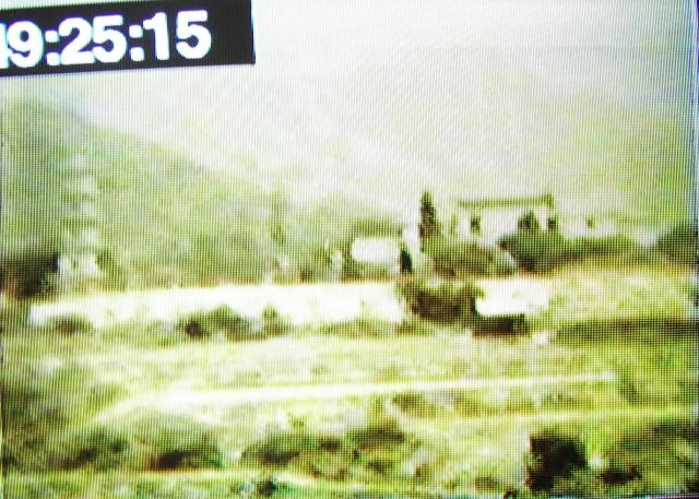
This is another "still" taken from an old 8mm film made in 1948.
It shows a pagoda, on a flattish terrain, it could be near the Kowloon hospital as the film shows the hospital shortly before. Or maybe somewhere in the New Territories?
Suziepie
Date picture taken
25 Feb 1948
Shows place(s)
Comments
A sharper copy would help for
A sharper copy would help for this one. I asked Phil what he uses to capture stills from videos, something he does regularly for his website: http://hongkongandmacaufilmstuff.blogspot.hk/
He recommends a free video player called VLC: http://www.videolan.org/vlc/index.html
One of its features is that it is easy to save a screenshot as a JPG image file. Here's how: https://wiki.videolan.org/Take_a_snapshot/
Regards, David
Re; Capture filmed images
Hi David,
If it is an actual projected image instead of a digitized media copy, it would be of no use using VLC. I don't think there are existing domestic movie to digital copy solution. You might be able to use a digital video camcorder on tripod to capture the projection on a proper screen, but that might still take some trial on error. Might still run into frame per second synchronization issues between the two.......
Thanks & Best Regards,
T
Hi T, I'm not sure how they
Hi T, I'm not sure how they're doing it, but Suziepie mentioned in an email that they're having the movies transferred to DVD. The photo above looks like a photo of a TV / monitor, so hopefully they'll be able to play the DVD through VLC and take some screenshots.
Regards, David
Re: Film to digital streaming conversion
Hi David,
There are professional service providers for this out there. But they might charge for an arm or a leg. I Googled a bit and found some of the equipments that could be found out there. Most are not for casual domestic users though.
Thanks & Best Regards,
T
Re: A pagoda maybe in New Territories
Anyone has an idea about where the pagoda is?
pagoda
perhaps the pagoda is an ornamental one sitting in the grounds of a small temple? without a clearer picture it will be hard to tell.
A different approach
Rather than - Where is it? Let's take a closer look.
Four building structures in what appears to be a walled compound.
In the foreground terraced farming.
A pagoda - ground plus five levels high. How common were pagodas of this size in Hong Kong?
Shadows and the sun - they seem to be apparent but which orientation?
Established trees - quite tall.
A farming area?
Barren tree less hillsides.
Interesting enough for someone to photograph it in colour. Was the film taken by someone in a car or bus passing by? How steady is the film?
Post WWII ?
Tung Chung hinterland?
Hong Lok Yuen, Tai Po before it was developed?
Thanks Dave -
Thanks Dave -
Really good comments. I've copied them and replied on them - see below.
My photo above has been taken with my digital camera of a DVD image 'paused' on the TV screen - unfortunately the image is not clear to start with and because I have 'paused' it there is a lot of flickering which makes it even worst. I do not know if I can somehow stop the flickering - to take a photo. Probably not.
The DVD is taken from a video - on which the original 8mm film was loaded. I have now had the video transferred to DVD - (because videos are now outdated!) - and for future generations I am having notes added to the DVD of who, what, where -(that is why there is a time appearing in top left corner - this is to facilitate the adding of my notes on DVD) - and hence the reason for trying to find out the answers to my questions by taking photo "stills" !.
NOW IN REPLY TO DAVE'S COMMENTS:
Four building structures in what appears to be a walled compound.
Yes - agreed.
In the foreground terraced farming.
Yes - agreed
A pagoda - ground plus five levels high. How common were pagodas of this size in Hong Kong?
I don’t believe so common - so someone should know where it is.
Shadows and the sun - they seem to be apparent but which orientation? - Don't know
Established trees - quite tall. - Agreed
A farming area? - I think so
Barren tree less hillsides. - Agreed
Interesting enough for someone to photograph it in colour. Was the film taken by someone in a car or bus passing by? How steady is the film?
The person, my Dad, was walking - as mentioned it is footage taken a few minutes after filming the the Kowloon Hospital - so I think it must be in that vicinity.
Post WWII ? - Yes definitely 1948
Tung Chung hinterland? - Don't know
Hong Lok Yuen, Tai Po before it was developed? - Don't know
Thanks for any further insight!
Suziepie
I wonder if this could be the
I wonder if this could be the Tang Clan pagoda in Tai Po with a few levels knocked off to make it safe.
Take a look at this website - http://www.amo.gov.hk/en/monuments_75.php.
The pagoda in the old movie film seems to be of a box construction with apertures - much the same as the Tang structure.
Not too far from Tai Po Market railway station - and perhaps the buildings are facing East of down Tolo Channel.
Edit - Tai Po may be wrong - recheck the Tang structure location.
My previous comment was
My previous comment was poorly written.
I am familiar with the Tang clan of Tai Po, but I do not know if there is an equally famous Tang clan on the west side of Hong Kong. Whichever it is, study the previously mentioned web site showing a current day photo of the Tang pagoda..
You will see that the construction of the pagoda is 'box' like and with a bit of concentration of the above frame you can see the same method of construction with apertures for windows/observation.
I do not think the filming person was filming everything on the same day. I suspect it was opportunist filming when out and about.
I have looked at the pagoda
I have looked at the pagoda on Google Earth and its slap bang outside Tin Shui Wai West Rail Station. I frequently go through this station and will stop off for a look and photo taking as and when.
I bet there is quite a bit of history lying around and if my luck is in - a few old phorographs.
A Pagoda in Kowloon or NT
Thank you Dave -
I have looked at the wrbsite you mentioned but I do not think it can be this pagoda.
- because the pagoda there does not appear to have any big hills or mountains behind.
If you look in my photo there are a couple of big hills - one even perhaps a mountain, in the far distance.
Suziepie
You're right there are no
You're right there are no hills and mounds now because this is Tin Shui Wai new town area. If you look on Google Earth your can see some indication of mounds. This area has been levelled in many places to make the new town fit.
Tsui Sing Lau Pagoda
I don't believe this is the pagoda in Ping Shan. That area has always been quite flat, even before the station and town was built (for example there are a couple of pictures from the 70's here: http://www.lurvely.com/photographer/23099064_N06/3/) and another here: http://www.hkmemory.hk/collections/hkplaces/AllItems/images/201107/t20110723_43818.html
Does anyone know when it was reduced to just 3 storeys? I was always under the impression is was outside of living memory (which is why no one seems to be able to give a date).
On an aside, is that white area in front a wall or is iot an open bit of land? I can't tell.
It's your lucky day Susiepie.
It's your lucky day Susiepie.
I visited the Tsui Sing Lau Pagoda at 09.30hrs today Monday 1st December 2014. Exit E3 from Tin Shui Wai West Rail Station.
It was manned by a lady security guard who was quite chatty. There is not much to see and inside there are a several small sketches and explanations in English and Chinese. What I read in English made little reference to the architectural structure. I spoke to the lady guard and explained that this structure has three levels and did it ever have a lot more?
She pointed out a brass plaque on the wall and I made a written note of the following:-
Tsui Sing Lau pagoda is the only surviving pagoda in Hong Kong.
This hexagonal shaped structure is a three storey green brick structure about 13 metres high.
According to the Tangs the pagoda had originally 7 storeys, but subsequently lost 4 upper storeys in two separate incidents - believed to be typhoons.
So there you have it.The person taking the Super 8 film must have known about it and in those days (1948) it could probably have been seen from a far distance - like Castle Peak Road. If you do more research the Lands Dept Mapping section may have some old Ordinance Survey maps and it would no doubt be a feature on them. From this you could work out the orientation of the structure and neaby buildings which would then give you the approximate location of the photographer.
I guess it just has to be the Tsui Sing Lau Pagoda
Thank you Dave -
For all that exploring for me - you must be right. So there you go - I have some unique footage of this pagadoa when it had al its levels!! Once I have the DVD perfected I will give it to David to put on Gwulo.
I have done a lot of googling myself and failed to find any other pagodas in HK - so I came to the conclusion that this HAD to be the Tsui Sing Lau Pagoda. And now you confirm it.
My dad was some 45 years in HK - went all over the place - he went to HK when he was a boy so knew HK very well and was very fluent in Cantonese, Mandarin and Haaka.
Thanks again
Suziepie
Suziepie and anyone else
Suziepie and anyone else interested.
At the time of visiting the pagoda on Monday I picked up a brochure of the Ping Shan Heritage Trail and have now studied it more closely.
Inside is a photograph plan showing the Ping Shan area in 1945 so I am going to enlarge it and see if I can find and then relate the pagoda to the buildings on the Super 8 film. There is also a line drawing of the pagoda so I intend to repoduce that in AtuoCAD and then scale it to reproduce the shape of the seven floor levels. What I cannot reproduce is the pointed top so I will guess that. Likewise each floor level seems to have contained a specific Chinese inscription and the main aperture may be of a different shape. Nothing is easy!
This is not a five minute job and I am busy getting ready for Christmas so bear with me on a time frame.
More evidence.
More evidence.
This all taken from the Ping Shan Heritage Trail booklet.
After viewing the Super 8 film above I previously suggested that the buildings had a perimeter wall around them. After looking at the layout of the trail and the photographers location, the buildings must form Sheung Cheung Wai . This an extract from the booklet:- Sheung Cheung Wai, situated west of Hang Tan Tsuen, was built about 200 years ago by a line of the Tang Clan that branched out from Hang Tau Tsuen in Ping Shan.
It is the only walled village along the Ping Shan Heritage trail.
Page 2 of the booklet has an aerial photograph of the area and terraces for farming can be clearly seen. I think I have spotted the location of the pagoda, but will need to confirm it. I may take a screen shot (above) of the padoga and show it to staff in the visitors centre. I expect they are normally bored stiff, but I have found that the locals will fire up with interst when shown a picture that requires some detective work.
AutoCAD of padoga going well.
Re: Pagoda in Ping Shan
Hi there,
I believe there is another crucial information that we have to match: When did the Tangs repair it to its present date. I could not recall reading anything on site about that, nor could I recall details while visiting the former Ping Shan police station. Might have to ask the elders.
Thanks & Best Regards,
T
I quite agree. In fact some
I quite agree. In fact some other questions arise. If the structure was intact in 1948 when did the two events of damage occur?
I bet there was some comment in the local newspapers about it.
I vave tried to load the
I vave tried to load the comparison images of today's padoga, and, in almost identical scale, what it looked like with seven storeys.
Admin may need to sort this out if I foul up the upload.
Re: Tsui Sing Lau Pagoda
The HK Memory Project comments that the pagoda was originally 5 storeys high as shown here (not sure if this statement is true) and that the top 2 storeys were destroyed by a typhoon in 1954. Anyways, a view of the area from 1955 as seen here As one can see the area near the pagoda is generally flat.
It seems very strange that
It seems very strange that the Hong Kong Leisure and Cultural Services Department (LCSD) can operate the HK Memory website and state that the pagoda existed with five levels on the one hand, yet on the other hand they operate and maintain the Heritage Trail and look after the existing three storey pagoda which contains a brass plate stating in in English and Chinese that the pagoda originally had seven levels.
I shall contact the Department and challenge them on the statements.
Looking more carefully at the Super 8 film above my eyes can see 6 levels with - I hope - the seventh lost to the poor film resolution.
Re: Tsui Sing Lau Pagoda
Hi there,
I have an impression that onsite material mentioned the pagoda was damaged twice, probably by typhoons. But it did not speficy any dates.
Thanks & Best Regards,
T
A Pagoda in New Territories -Tsui Sing Lau
Thank you David for this link "here" in your above comment.
I have checked into it and blown up the specific part of the photo around the pagoda - NOW I can definitely see the same image as my 8mm film photo above. I see the pagoda with its 6 (maybe 7th in haze) levels. I see the close hill behind and further mountains. I see the buildings close by on the right. I see the long wall in front. I see the terraces in front of that. So yes, this is definitely the same place - taken in very much the same angle.
Thank you.
Regards,
Suziepie
Pagodas
Suziepie, if you've managed to get a sharp screen capture, please could you upload it for comparison?
Here is Dave's reconstruction of the Tsui Sing Lau pagoda:
And I've made a page for the Tsui Shing Lau pagoda at: https://gwulo.com/node/22435
Regards, David
For the curious, I have e
For the curious, I have e-mailed the Leisure and Cultural Services Dept and received a nice reply. My comments concerning the 5 or 7 storey padoga question have been circulated to various people and a reply will arrive in due course. There is a lot more to this padoga than meets the eye so I plan to do some more research so that this Forum entry has a really worthwhile content on what its all about.
Test picture insertion
If this attempt works the picture will show the padoga 'as is' and the conflict between 5 and 7 storeys which is now undergoing examination.
Dave W
Re: Tsui Sing Lau Pagoda
Another explanation of the height of the pagoda as shown here
Tsui Sing Lau Pagoda
Moddsey - is the picture in that link supposedly from 1930? If so, then it should confirm that the pagoda was already only 3 stories by that time.
Its now getting interesting
Phil and Moddsey,
Thanks for the contributions. This is getting complicated. According to the Ping Shan Heritage Trail booklet it shows an ancient drawing on page 2 which indicates that a tidal creek may have extended to the area. On the drawing there is a padoga depicted next to the creek.
Now we have, circa 1948, a freeze frame extract from Super 8 cine film with a pagoda of at least 6 levels. Other contributions to this topic connect references to documents that suggest 5 or 7 levels. 1948 is very recent history and the subsequent loss of any floors from this pagoda must have been the talk of all the tea houses in Yuen Long and beyond. The newspapers must have some record of the event(s).
Lots of people must have photographed this pagoda post 1948 so where are they?
There is also mention of a moat around Sheung Cheung Wai (since filled in) yet some of the connected websites to submissions on this topic show a water feature next to the padoga (3 storey).
Keep posting, "we" should be able to resolve this historical enigma.
Dave W
Re: Tsui Sing Lau Pagoda
Hi Philk - the photo in the book is available on HKPL as seen here is believed from the 1950s. So no confirmatory evidence at this juncture.
Pagodas in Shenzhen similar to Tsui Sing Lau
Some similar structures in Shenzhen (description in simplified Chinese): http://wb.sznews.com/html/2014-05/15/content_2874071.htm
AutoCAD drawings
Just trivial information, but when I was re-drawing the existing three level pagoda shown in the Ping Shan Heritage Trail booklet it soon became apparent that there is a ratio formula to determine the size of the hexagon shape for the structure at each level. Refer to the above drawings.
From this I was also able to draw in the taper of the structure from ground level.
My conclusion is that Chinese architects and padoga builders had already worked out the design requirements before they built the structure. Having this information to hand would also enable them to work out a Bill of Quantity for bricks, tiles and mortar etc. From this they would also be able to calculate the weight of the structure and the suitability of the proposed site to accept the load.
Since padogas are fairly common structures in China and elsewhere, perhaps there was a 'standard design' for them.
Pagodas
While this discussion has concentrated on the pagoda in the Ping Shan area, there is another one overlooking Shatin at the 10,000 Buddha temple. It has mountains behind it as per the screen shot. It was built as far as I can find out soon after the war and is certainly much higher than the Ping Shan structure. No doubt it would have been a sight to visit when it was being built or completed, and much easier to reach in that period as the railway station was just below in the valley.
IDJ,
IDJ,
Thanks, I looked at it on various web sites. It doesn't match. The apertures on the Shatin padoga are very different at the various elevated levels. Moreover, the Super 8 film at the top of this forum entry clearly shows some degree of terraced farming or agriculture in front of the padoga: this is replicated very clearly in the Ping Shan Heritage Trail photograph circa 1945. The corbel design at the different levels is also different. Corbels - for simplicity - the bits that protrude outwards.
I wonder where (or which Department or organisation has) the 1945 aerial photograph?
Pagoda-aerial images
In theory is should be the Survey and Mapping Office, Lands Dept of HK government based now at North Point, but they didn't start taking aerial images themselves until the mid-sixties. In 1945 it was probably the Royal Air Force or Royal Navy aircraft who was taking aerial images. Some may have found their way into the HK government archives. The people at North Point are usually quite helpful to queries on what they keep on file..
mapping office
you don't have to go to North Point. The various district sub offices of the mapping dept have all the same facilities available. I usually use the one in Tai Po for convenience. They have a computer system that allows you to inpoint place, altitude and year for matching photos - prints usually cost $120 and take about 4 days,
Re: Pagoda in Shatin
Hi IDJ,
As far as I could recall the architectural style of the pagoda in Shatin is a bit different. The one in Ping Shan is probably having something to do with Feng Shui. I have a good friend studying Feng Shui and he told me that the one in Ping Shan is what they usually call a Man Cheong Pagoda (文昌塔). The one in Shatin is for budish worshipping. Even the appearance of the two are quite different, if you compare their photos.
Thanks & Best Regards,
T
The Observatory website
The Observatory website contains a database for typhoons so I now have the data for typhoons where signal number 8 or higher was raised between 1948 and 1966.
The latter date is connected with the following URL which purports to show the Tung Sing Lau pagoda intact in 1966. http://www.panoramio.com/photo/32808484
I’m trying to narrow down the time frame for the reported damage.
I shall probably be shot for
I shall probably be shot for copying very poorly from the Heritage Trail booklet, so find below a rough extract of a very old map setting out the beginning of the Tang clan real estate. Lots of details are missing – names of hilltops and so on.
The two important features are the locations of what I assume to be the temples (shown in red) which can be seen on Google Earth today and the small pagoda next to the creek/inlet or whatever name is applicable.
The problem I have is trying to work out the scale with the 1945 aerial photograph which also shows the temples. On the attached JPEG picture I have marked 1, 2 and 3 to suggest that one of these locations is the position for the seven level pagoda as per the Super 8 film at the top of this topic.
I am beginning to think that - over time - there may have been two pagodas. I doubt if a seven level pagoda would be constructed next to a waterway because the earth surrounding would be very soft and wet. The Yuen Long flat areas around the Kam Tin River are sitting on top of very thick and soft esturine mud deposited hundreds of thousands of years ago. Thus building a pagoda at the base of a substantial hill or mound such as positions 1, 2, or 3 makes more sense.
For the typhoon database I have now extracted No 10 signal typoons between 1948 and 1966 and have the following:-
1957 Gloria, 1960 Mary, 1961 Alice, 1962 Wanda, 1964 Ruby and Dot.
Any thoughts?
1900s Ping Shan
From the National Archives, a view of Ping Shan as seen here probably not long after the completion of the Police Station.
I have spent at least one
I have spent at least one hour this Sunday morning studying the 1945 aerial photograph of the Ping Shan area shown on page 2 of the Heritage Trail booklet. In an earlier post I made reference to terrace lines in front of the pagoda - I now have the impression that these so called terrace lines may in fact be some form of damage on the original negative or photograph.
With the help of Google Earth and the 1945 photograph, I believe I have now found the site of the pagoda and the Sheung Cheung Wai village which was built with a surrounding protection wall.
In my Auto CAD drawing above I suggested options 1, 2 and 3, as possible location for the site of the pagoda - these can now be ignored. Today's pagoda is precisely where it is illustrated on the AutoCAD drawing - next to the creek/channel which no longer exists.
Today (Sunday) or tomorrow, I plan to revisit the area and the visitors centre to verify the pagoda position on the 1945 aerial photograph. The only task left after that is to try and find a drawing or photograph of the pagoda in its heyday.
A Pagoda in New Territories 1948 - probably Tsui Sing Lau
Hi David, David W, Moddsey, IDL, Philk
Thanks for all the input - you will see that I have uploaded 3 more images - this time done a lot better following David's advice (and not using the TV monitor). So it should be clearer - and there are definitely terraces in front of the Pagoda.
The 2nd image shows the 'frame' following the Pagoda - and shows a clearer image of the buildings alongside.
The 3rd image shows boys on buffalo somewhere in the foreground - near vicinity by the way the camera sweeps around.
Perhaps David you could add the uploads to this forum topic. I don't know how! Thanks
Regards,
Suziepie
Pagoda photos
Thanks to Suziepie for the new photos. I've combined the two that show the buildings:
And here's another photo that may show the vicinity (if it was part of the same clip as the photo above, it will show the same area, but if there was any break in filming it may show a different location):
With a clearer view of the terraces and wall in front of the pagoda, we can rule out Tsui Shing Lau as a possible match. That was built at ground level on flat land:
So which pagoda are we looking at in Suziepie's photo? Do the buildings or hills remind anyone of a site in Hong Kong? Are there characters on the wall below the pagoda - maybe a hotel or recreation area?
Regards, David
pagoda
I don't think the building style is that common anymore. It looks like a private 2-storey house, very old and reminiscent (to me at least) of the miu gok yuen nunnery at Fung Kat Heung nr Kam Tin. However,I'm sure in the 40's there were many more similar style buildings to be found.
[Edit: added photo example]
Chi Lin Nunnery ???
What about the Chi Lin Nunnery at Diamond Hill as seen at: https://hk.images.search.yahoo.com/images/view;_ylt=A8tUwJqAOoZURj4Ah8a…-?.origin=&back=https%3A%2F%2Fhk.images.search.yahoo.com%2Fsearch%2Fimages%3Fp%3Dpagodas%2Bin%2Bhong%2Bkong%26fr%3Diphone%26fr2%3Dpiv-web%26spos%3D12%26nost%3D1%26tab%3Dorganic%26ri%3D68&w=459&h=218&imgurl=www.metropolasia.com%2FloadedFiles%2Fchi-lin-nunnery-in-hong-kong.jpg&r…
Re: Chi Lin Nunnery
The buildings of Chi Lin Nunnery are quite new. I think they were built in the late 1990s. I believe the previous buildings were surrounded by squatter areas and were quite nondescript.
Re: Chi Lin Nunnery
i seem to think the nunnery was established in the 1930s. Not sure if a pagoda was also constructed.
Re: Unlikely to be Chi Lin Nunnery
Hi there,
I believe it is unlikely as you would have Kowloon Peak/Tate's Carin in the background. The skyline didn't add up.
Thanks & Best Regards,
T