I found this very interesting Japanese position on Mt Cameron last week.
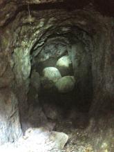
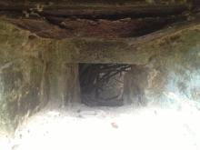
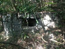
We started at the valley near the top between the two summits, and followed the path down past the old covered reservoir towards middle gap rd. A couple of hundred metres down we jumped down the left side into the stream valley and found this Japanese Pillbox. It is U-shaped with two loopholes, one facing upstream and the other downstream. There was a tunnel in the middle of the pillbox about 3 metres deep and then bending away into the hillside. I jumped down for a look, but the tunnel only went into the hill about 10m. The original roof has collapsed but you can see where the support beams once held it up.
This is the first time I have come across a Japanese Pillbox and tunnel with this design. There is a much bigger tunnel network on Black's link (see: http://gwulo.com/node/3112) with a brick gun position in front, but that is little more than a small wall with a loophole to fire out of.


Photos that show this Place
Comments
That's very unusual. What was
That's very unusual. What was it built to protect?
The Japanese war memorial wasn't far from here. There's the comment from the Japanese Major that the memorial was a tomb where all the Japanese would gather to die when Hong Kong fell. Could this pillbox be part of defences around this centre of the island where the Japanese would retreat to?
Regards, David
Re: Mount Cameron.....
Hi there,
The site of the Japanese memorial and the pillbox were on two different sides of Wanchai Gap. Under Google Earth I draw a path linking up Cameron Building and the approximate location of the pillbox. The elevation profile of the path shown the pillbox could not see the memorial site at all as Mount Cameron itself was in the way.
This made me wonder what is the strategic value of this pillbox.
My 2 cents,
T
GPS location ?
Hi, does anyone have the exact coordinates? I did the ribbon trail a few times without knowing there's a pillbox and tunnel but nothing ever caught my eye.
Anyone knows the exact
Anyone knows the exact location of this PB?
I tried to follow what Craig described above, heading down west from the old covered reservoir and reached the stream. Then I started searching near the stream but eventually I found nothing...
By the way, is the pin being placed at the right position near the PB? Coz I notice that there is some distance between the stream and the pin...
Japanese PB on Mt Cameron
Hi there, the pin is in the approx correct place. (about 22.263245°, 114.175298° on google earth)
If you are walking down from the top ridge and have walked over the flat covered reservoir, then as soon as you walk off the reservoir and start descending, drop down the left side (south) and follow the gully down. At the very top you will see a load of old pipes and values, keep going further down and you find this PB (about 80m from the reservoir).
A little lower in gully on the righthand side of the path is a collection of Japanese tunnels that have mostly collapsed. looks like quite a bit of work went into it. You can still gain access if you head up the other side and around the corner where there is an entrance. There is also a set of very rusty shutter doors laying on the floor which once protected the gun loop.
Thx Craig I will search for
Thx Craig I will search for it again next week :)
Video on the PB
I have go there on 2021 and make a video, please start from 07:00, enjoy!
pillbox
How come this pillbox is relatively unknown. No historian has written anything about this pillbox even though it is very historically significant. Someone really needs to survey the site out, since I believe it served as a "last outpost" before the Japanese all commited suicide in the war memorial which was only a mile away.