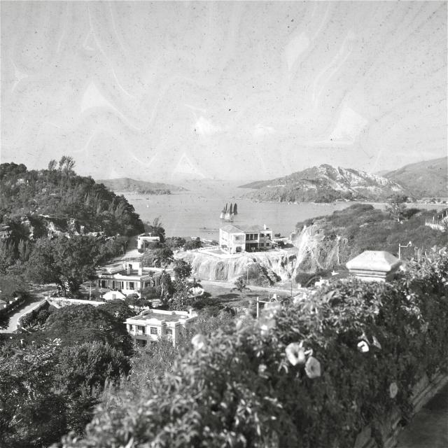
[Identified as Penha Hill in Macau in the comments below]
Can anyone identify where this is? I have scanned the picture from some old slides my father took in the 1950's and can't place where this is.
Date picture taken
1950s
Gallery
Comments
hoping to retribute something
Hi,
I started my search for this image back in June when I made a post to a Talk forum on wikipedia. Somebody replied to my post suggesting I post a similar request to gwulo.
Instead of posting I decided to poke around gwulo to look for clues. A first session some months ago got me nowhere. A few days ago I tried again.
Suddenly, after a long, long, search through your photos I found myself looking at virtually the same image I had been trying to identify.
By the time I got to the end of page 2 of this thread and visited the related uwants discussion, I realised I could finally discard my theory that the photo was taken from somewhere near Tai Po looking north-east along Tolo Channel, if it was taken anywhere in Hong Kong at all.
In the hopes that I can retribute something I am posting a table full of links which aims to tell the story of my search in as concise and useful a way as possible.
The main purpose of the table is to pull together the many pieces of information I have found on my search. Added to this are a series of wikimapia links to locations which (I believe) definitively define the locations of the viewpoint, the central house, and the island in the centre of the channel at the centre of the view.
My hope is that this table will provide a useful summary of all that has been found on this search, by all concerned.
houses to left of sightline ( site of large square single-storey-on-plinth house - house replaced by residential buildings | smaller white house in valley - house still appears to exist )
Macau+10kms ( 1912, Portuguese | 1555-2011, animated topographical, French ) |
Macau+150kms, Canton / Guangzhou / Pearl River estuary, Hong Kong ( 1753, detailed, Dutch | 1890, German | 1910 )
...no longer exists:
Thanks Kalis, it's good to
Thanks Kalis, it's good to see some of the other sources available online.
Do let us know if you find any other interesting old photos,
Regards, David