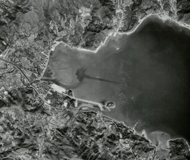
This shot shows Tai Po around 1963 when the reclamation for the Plover Cove estate had been completed (the white area at the top of town). This was also the time when the layout for the 4-lane square area was being put down (thats the larger empty space to the south of the white reclamation).
Tai Po Market town had already been developed (starting around 1892 when the Fu Shin Market was established) and you can just make out the train line winding along the coast and curving south of the town area.
There is a pier sticking out into the water where Tai Po station was (not to be confused with Tai Po Market station in town - now the railway museum) but this was demolished in the 1980swhen the line was electrified.
Yuen Chau Tsai - where the district officer lived - is the small island (centre right) just off the coast and you can see where Tai Po road comes down the hill and curves left past it. From there it becomes a causeway which for many years had a hoklo shanty town along each side of it. The shanty 'town' started off as boats (like in Aberdeen) but became a full-on stilted village around the early 70's. That whole area was reclaimed in the 1980's and most of the old fisherfolk were moved into the Govt housing estate that was built there: Kwong Fuk Estate.
The station was Tai Po Kau. The adjacent pier was for many years used by the Marine Police, and Marine Department, operating from a small building on the landward side of the jetty. The pier was reputedly built for a defunct China ferry service, and a bricked - up ticket office was visible at the station end of the pier.
Thanks philk - interesting picture, with the safety hoop used in single track days about to be handed to the train driver. Steam engine?
By the way do you know when Yau Ma Tei KCR station was renamed Mong Kok , and why? I remember YMT station still appeared on ancient timetables visible on the notice board at TPK in the 1970s.
Actually I have no idea when YMT was renamed Mongkok, although there are a few snaps of it on FLICKR looking almost as though it was in the middle of the countryside!
The line underwent a major overhaul in 1983 when it was electrified (this was also when Tai Po Kau station was decommissioned) so perhaps it was then - I'm no expert I'm afraid.
I think Pete Moss did a KCR history book for its centenary year, so perhaps we'll find the answer in there. I'll have a look next time I am in a bookshop.
I have fond memories of Tai Po Kau Marine Police base as it was my first posting in 1976 after the Police Training School. Actually only the top floor of the building was used by the officers of what was then known as Marine North Sector (later Division).
The ground floor of the building was Shatin Divisional (later District) Headquarters. I have been told that the pier and the building still exist, but I haven't been back there in nearly 40 years!
I do remember that when the KCR was electrified, before it was merged with the MTRC, the railway was realigned and moved inland - when Tolo Highway was built. I didn't know the story of the defunct ferry service to China, so thanks for that Ho Lim-peng.
Comments
Tai Po Aerial circa 1963
This shot shows Tai Po around 1963 when the reclamation for the Plover Cove estate had been completed (the white area at the top of town). This was also the time when the layout for the 4-lane square area was being put down (thats the larger empty space to the south of the white reclamation).
Tai Po Market town had already been developed (starting around 1892 when the Fu Shin Market was established) and you can just make out the train line winding along the coast and curving south of the town area.
There is a pier sticking out into the water where Tai Po station was (not to be confused with Tai Po Market station in town - now the railway museum) but this was demolished in the 1980swhen the line was electrified.
Yuen Chau Tsai - where the district officer lived - is the small island (centre right) just off the coast and you can see where Tai Po road comes down the hill and curves left past it. From there it becomes a causeway which for many years had a hoklo shanty town along each side of it. The shanty 'town' started off as boats (like in Aberdeen) but became a full-on stilted village around the early 70's. That whole area was reclaimed in the 1980's and most of the old fisherfolk were moved into the Govt housing estate that was built there: Kwong Fuk Estate.
Tai Po Aerial circa 1963
The station was Tai Po Kau. The adjacent pier was for many years used by the Marine Police, and Marine Department, operating from a small building on the landward side of the jetty. The pier was reputedly built for a defunct China ferry service, and a bricked - up ticket office was visible at the station end of the pier.
Tai Po Kau station
Hi Lim-peng - actually the station was only named Tai Po Kau much later in life. Previously to that it was simply called Tai Po.
There was an old Bruce Lee film called "An Orphan's Tragedy" which used the station as a filming location. You can see it in this screen grab:
http://www.flickr.com/photos/31063481@N03/4330185914/
It was made circa 1955 and you can see the old name on the sign in the background.
Thanks philk - interesting
Thanks philk - interesting picture, with the safety hoop used in single track days about to be handed to the train driver. Steam engine?
By the way do you know when Yau Ma Tei KCR station was renamed Mong Kok , and why? I remember YMT station still appeared on ancient timetables visible on the notice board at TPK in the 1970s.
YMT station
Hi Lim-peng
Actually I have no idea when YMT was renamed Mongkok, although there are a few snaps of it on FLICKR looking almost as though it was in the middle of the countryside!
The line underwent a major overhaul in 1983 when it was electrified (this was also when Tai Po Kau station was decommissioned) so perhaps it was then - I'm no expert I'm afraid.
I think Pete Moss did a KCR history book for its centenary year, so perhaps we'll find the answer in there. I'll have a look next time I am in a bookshop.
Cheers
Phil
YMT Station
Many Thanks-it was certainly well before electrification, which I remember well, and I've just had a look at Wikipedia, which says it was 1968.
best regards
HO Lim-peng
Tai Po Kau
I have fond memories of Tai Po Kau Marine Police base as it was my first posting in 1976 after the Police Training School. Actually only the top floor of the building was used by the officers of what was then known as Marine North Sector (later Division).
The ground floor of the building was Shatin Divisional (later District) Headquarters. I have been told that the pier and the building still exist, but I haven't been back there in nearly 40 years!
I do remember that when the KCR was electrified, before it was merged with the MTRC, the railway was realigned and moved inland - when Tolo Highway was built. I didn't know the story of the defunct ferry service to China, so thanks for that Ho Lim-peng.
Happy days - sometimes!