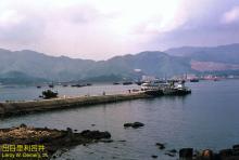
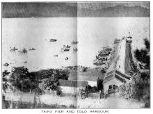
The pier opened in 1910 at the same time as the adjacent Tai Po (Kau) Railway Station. The pier was a dam built out into the sea with a (wooden?) pier at the end. It had a total length of about 180 m (source)
It was used as a ferry pier to nearby islands. I could not find any ferry services in the first decades. In the 1970s and early 1980s, a ferry service was active to Tap Mun and Tung Ping Chau. It is reported that in 1983, the ferry routes were moved to the Ma Liu Shui Pier near University station (source).
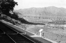
This was in connection with the decommission of the railway station and the construction of the Tolo Highway. For this, land was reclaimed and a part of the pier (the dam) disappeared under the new road.
In the 1970s, a marine police station was constructed which also used the pier (source).
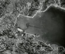
The pier still exists. At the end of the pier, a tide gauge station was installed.
Photos that show this Place
Comments
Re: tide guage
Information about the tide guage could be found in HKO's website.
Tai Po Kau Marine Police Base
The RHKP Marine Police Base mentioned was, in the 1970s, officially referred to as North Sector Headquarters. (The Colony's waters were divided into 4 Sectors, not including the Harbour).
Part of the building also housed the (land Police) Shatin Divisional Headquarters. This was before the Force expanded and Regionalisation was introduced, when Shatin Division became Shatin District.