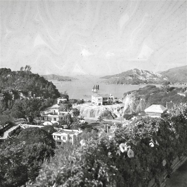
[Identified as Penha Hill in Macau in the comments below]
Can anyone identify where this is? I have scanned the picture from some old slides my father took in the 1950's and can't place where this is.
Date picture taken
1950s
Gallery
Comments
Sai Kung?
There are several small islands, could it be out around Sai Kung / Clearwater Bay?
Regards, David
street lights
The street lights look to be a very unique design. I wonder if anyone can recognise them, it may help us locating this.
Re: Colonial style buildings.....
Hi there,
My observations:
-The concentration of buildings definite has some Colonial origins;
-The barren hill on the other side might be another clue;
-There is a fenced up area by the far right, on the slope that looks like a restricted area;
I wonder if the site was military or government quarters of sort.
Best Regards,
T
castle peak?
By sheer and utter fluke I stumbled upon this photo dated 1960, which says it is near Castle Peak - hopefully that'll help narrow it down
http://www.ibiblio.org/hkpa/scenic/ftp/nt1960a.jpg
islands
I'm not so sure, the proximity of those islands is too close to be Castle Peak - maybe closer towards Tsuen Wan. Could be around Tsing Yi/Ma Wan area?
Re: Islands...
Hi there,
I tend to believe the photographer was standing up in a courtyard a bit up a slope, somewhere around the Siu Lam area. That area used to have a few barracks and those buildings looks like some sort of quarters. Maybe a bit up the slopes with the knoll on the left just blocking Pearl Island from the view?
The bararen hill fits the Castle Peak area as well. If you use Google Earth the hill looks quite similar.
As for the islands, the far away islands could be Sha Chau. The bigger and closer one might as well be Chek Lap Kok.
My 2 cents,
T
Re Photo
I believe taken from Siu Lam/Tai Lam Chung area. The scene opposite is Yam O (Sunny Bay) Lantau Island.
Re Photo
Perowne Barracks?
Castle Peak?
Given that Alison's father's picture and the Paul Popper picture from the Fragrant Harbour book that I posted are taken from virtually the same spot, it would suggest that they were taken from somewhere with easy public access. And as both appear to have been taken at lunchtime with the lighting directly overhead, possibly they were taken from a hotel or restaurant balcony. There would not have been many eating places suitable for visitors to be taken to in that area in the 1950/early 60s. The small island in the centre of the images could be Pearl Island before the causeway access was built? Paul Popper was a well-known photographer at that time who took many Hong Kong pictures. His negative archive is held by a UK picture agency and does not appear to have been explored to see what other pictures are in it with a Hong Kong interest.
Re: Photo
Cannot be sure but the fenced-off area to the extreme right may be Tai Lam Prison.
Castle Peak?
I think it is fascinating that you have found a picture that is so similar to the slide that I have, IDJ, and assume that it must be somewhere on Castle Peak. I remember that we used to go there for outings on weekends when we were very young, so perhaps this was taken on one of those occasions. On the other hand, my father was very active in the Royal Hong Kong Defence Force and used to go to the New Territories (to Sek Kong) for training from time to time, so maybe the photo was taken then. Thank you to everyone who has tried to solve this mystery!
Regards,
Alison
Castle Peak
Actually, I'm no longer convinced this is Castle Peak area. The arrangement of islands doesn't add up. If this is somewhere along Castle Peak road then the only place it could be would be facing one of the narrow passages between islands: either the gap between Lantau/Ma Wan or the gap between Ma Wan/Tsing Yi or the gap between the mainland/Tsing Yi. None of the background measures up to any of those.
Looking through the gap on 80'skids clearer picture you can see an island in the middle distance. If this were the gap between Lantau and Ma Wan - which island is that?
Can anyone identify the distant ridgeline? It doesn't look like HK Island.
Re: Distant Ridgeline
Been on a boat trip today. With ref to 80s kid photo, if it helps the ridge line in the far distance looks like Lamma and Mt. Stenhouse.
Mt Stenhouse
Moddsey - do you have any snaps to compare? I think Stenhouse is more jagged. That one looks quite flat along the top.
Re Photo
Sorry don't have the angle for the ridgeline on Lamma. One needs pretty good viz for that!
Phil - please see if this is a possble match up of the scene from Dragon's Beach and/or Tsing Lung Tau:
http://www.flickr.com/photos/littlepillow/94583538/in/photostream
Re: Tsing Lung Tau?
Hi there,
I believe it does not add up. But hey, that's the fun of looking at these photos.
Best Regards,
T
Thanks Moddsey. I must admit,
Thanks Moddsey. I must admit, I just don't think this is from that area. But to be honest, I'm having a hard time making anything match at the moment.
The proximity of the land either side might mean an entrance to a bay rather than a gap between islands? Or the gap between a headland and an offshore island?
I'm flumoxed at the moment but fairly convinced it's not in Castle Peak/Tuen Mun or anywhere along that strip of coastline along the Rambler Channel. If it is that area then I don't think it's taken Mainland side.
Could be Port Shelter somewhere?
Thanks Phil
I am just as baffled as you. I will ask around and see if anything turns up as a lead.
Tsuen Wan?
A wild guess here...
But could this be looking to the west from Tsuen Wan (below Sheung Kwai Chung area), looking directly at the channel out to Ma Wan, with Nga Ying Chau/Tsing Yi on the distant left, Yau Kom Tau/Ting Kau on the right, and Ma Wan/Lantau in a distance straight ahead?
Tsuen Wan would be in the central right before any reclamation had taken place.
Sheung Kwai Chung
If you look west from Sheung kwai Chung all you will see is Tsing Yi blocking everything from view, so I don't think so :-(
Make a guess.
They are western style houses. I don't believe the location is in any places in NT above Boundary Street. Sai Kung or Lantau Island? ha, ha! May be south of HK Island.
The style of houses seem not unique, I don't believe they are government quarters and even military quarters.
The shape of the islands
The shape of the islands (some quite flat) remind me of various places around Port Shelter, but then the street lights completely throw me because that implies a significant investment in electrical infrastructure - not somewhere remote, so I agree with lolau, but then again where could it be? Where in HK had nicely laid out roads, curvy streetlights and that kind of view?
Notice how calm the water is on both pictures as well? It could be a coincidence I guess but it looks as though this body of water is fairly well-sheltered (so I don't believe its South HK Island eitehr).
Castle Peak area...
I still think the photo is most likely taken from Castle Peak Road - it was very well established in early years and had some popular beaches and hotels/restaurants such as Dragon Inn. It was also, in the 50s, one of the few places you could go for a long drive. The road was built around 1918. Of course, there's the problem of several islands that no longer seem to exist.
This photo of Hotel Pearl Island (which I'd never heard of before) could be sited on the island in the background of the photo. The barreness of the hills certainly fit, while the bay with its flat land behind can also be seen. If I'm right, then the original photos could have been taken from the hills in the background of the govt photo.
http://www.grs.gov.hk/PRO/imgroot/4-2/4-2-39.jpg
I'm not entirely sure where Pearl Island was, according to one book reference it was 17 1/4 milles Castle Peak Road. The govt photo was taken 1971.
Pearl Island
Pearl Island is located right outside The Gold Coast, not far from Tuen Mun and just off from Castle Peak Road.
I looked at this again and it cannot be seen from Sheung Kwai Chung as I said previously. The scale is completely wrong, sorry... haha
What a head scratcher.
old buildings
my 'gut' goes for castle peak too - there were some fine buildings that way, dragonville and dragonette (occupied by the fire chief and police chief for the nt in the 60s) - opposite a fairly opulent mansion used in one of the bond films - just fits my nebulous childhood memory of castle peak - was a fairly frequent visitor and beach goer in the 60s ;)
1950s Castle Peak
Probably taken from the Castle Peak Hotel looking south-east. The hills of Lantau are opposite. Posted for comparison.
Photo - Castle Peak?
I found a photograph on the internet. It is taken at Yuen Tun catchwater looking towards Kap Shui Mun Bridge.
http://www.fotop.net/RickyWu/RickyWu10/009_G
The old photograph was probably taken a little west of this, and on a lower altitude.
Castle Peak
It's the closest match yet to the original snap but comparing with the clearer version (link posted above by 80'skid). The background just doesn't add up :-(
Old Tuen Mun photo
Hi there,
Found this photo and this photo through the Lingnan University Tuen Mun Heritage Photo archive. Just got another one from the Public Library archive.
The direction of these photos are not the same as those we have seen in this thread before, however I think the barren hill on the right hand side may be one and the same.
Best Regards,
T
Re: Old Castle Peak Bay
Hi there,
I have a theory.
The more I study the photo I had had a feeling that it was the old Castle Peak District alright. However it is NOT near Siu Lam as I suspected. Instead it might have been closer to the Kadoorie Beach/Castle Peak Bay area, ie, close to present day Sam Sing Estate.
Let's assume the barren ridge is the lower spur of Castle Peak toward the present day CLP power plant, the shorter distance across the sea appears to more or less a match to the old photo. There s also a knoll atop Kadoorie Beach. If this is the case the photo graph has to be taken a bit back up on the slope near the barracks. Don't know if the fenced off area was part of the few barracks back then. Also if this is the case, the nearer Island should have been Chek Lap Kok.
Gotta have a field trip to the beaches along the Castle Peak Bay area on a clear day to be sure.
Best Regards,
T
re: Kadoorie Beach
Present day view from above Kadoorie Beach
http://g.co/maps/gcmbv
View from Dragon Inn?
Some experts on the Uwants forum think that it is possibly the view from Dragon Inn (19 Miles, Castle Peak Road):
http://www.uwants.com/viewthread.php?tid=7206167&pid=178705054&page=134
bingo!!
C - an excellent discovery and I see someone has an excellent colour version as well that shows much more detail to the right hand side e.g Castle Peak. So does that mean that the background I was trying to identify is actually the Macau-side of China?
Re: bingo
Great coloured shots. But which direction are we looking at south or west?
South west?
But it looks as though most of the right hand side of the headland has been removed? And of course Chek Lap Kok had it's own fate. However, I'm still wondering which island that is in the distant middle background. There doesn't seem to be anything today that matches it (unless I have the direction wrong). Either way, it looks as though T was onto the same/similar location in the other thread.
If you look further down on the uwants thread you'll see someone has posted a picture of the Macau Electric boss's house that was also in the vicinity.
Re: south west
I guess we can only be looking south west, if that is indeed the place and Chek Lap Kok is in the photo. As for those islands, I just want to ask whether there is some sort of land reclamation since the 1960s over there? Maybe one (or part of) of those islands got reclaimed or the hills knocked down to make way for buildings?
I am still a little confused about the exact location, please excuse my ignorance.
Re: South West
Hi there,
There had certainly been massive reclaimation in Castle Peak area. You should be able to view a group of photos in links in another post.
Best Regards,
T
tuen mun
Hi, that whole area was completely altered to construct tuen mun
http://hkclweb.hkpl.gov.hk/hkclr2/object?svc=objrtv&src=CM&itemid=VYU1Y4VLQAJ81Z@W&pid=1&mime=image/jpeg
Great find
Great find
Photo - Castle Peak? Macao!
Problem seems to have been solved. It is Macao -- looking down from Colina da Penha towards the southwest.
Please see the additional photos and analysis (in Chinese) here:
http://www.uwants.com/viewthread.php?tid=7206167&extra=page%3D1&page=135
Macau
Oh my goodness, that fellow on Uwants really solved the entire mystery. How can this person recognise the lines traced by the hills?!
For non-Chinese reading Gwulo people, in a nutshell, it's looking southwest not from Castle Peak, but from Penha Hill. All the close by hills and islands are China. I surmise the island on the left hand side is Xiao HengQin Island (Small HengQin), present day part of HengQin Island which is the reclaimed result of Small and Big HengQin.
And I have to say I have seen that net catching fish in Macau in the 80s.
The distant hills barely traceable in the photo are also part of China.
Macau!
I take my hat off to the uwants guys and it's nice to know the art deco mansion of the Macau Electric boss still exists.
Re: Macau
Hi there,
Aha, no wonder part of the headland and the island did not match. When I was in Gold Coast last week I keep on having a feeling that it did not add up. Good catch though.
Best Regards,
T
Re: Macau!
Those guys on Uwants are experts. The whole thread (135 pages!) is about a (formerly) weekly "game" of identifying places in old photos.
macau
super sleuth work! i would never have got there in a month of sundays even though thousands of macau shots have passed through my hands. now i can see 'skyline' but none of the foreground is on my scanner :)
What sleuths!
Thank you to everyone who has been on this "mission" - it now makes sense. My father would have gone to Macau fairly often and stayed at the home of the Macau Electrics boss (as mentioned in a previous post) and this slide was in the box with the Hong Kong slides, so there was no indication that it was from anywhere other than Hong Kong! This goes to show that the Gwulo team are really "on the ball" My very grateful thanks.
Not Castle Peak (I think)
Hope it is not too late to join in the fun. I venture to suggest this was a picture of Tai Tam Bay near Stanley. The photographer probably took this from a point not far from Red Hill Peninsula looking south. The two islands in the distance were Beaufort Island and then Po Toi.
no not Castle Peak
but not Tai Tam either. The location is in Macau, somewhere on Penha hill looking southwest.
Colour Photo of the Same Area
Colour photo from 1967 of the same view
I found another of these colour photos taken in 1967 from the Macau
Old Photos Facebook page: https://www.facebook.com/#!/photo.php?fbid=2993785493277&set=o.26556752…