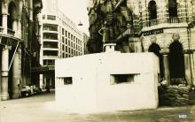
I received an interesting email about this. First there is another photo of the area, but this one taken in 1945:
You can see the same low concrete structure in the background, but this photo gives a better view of where it was in relation to the sea and the GPO building.
Second, the writer wonders if it was a pillbox at all:
Situated on the praya, it does not appear to have openings facing the sea. Furthermore, it appears too close to the GPO for it to be a pillbox. As the news clipping you provided says - it simply could be a pen shelter constructed on a wide road.
I don't think it was a pen shelter. The couple of photos we've seen of them show they are clearly made from bricks, but this structure looks more like the solid grey concrete we've seen on other pillboxes.
Also, in photo 22 you can see an opening, whereas the pen shelter walls are solid. That opening looks like a pillbox loophole, but unfortunately neither photo gives a clear enough view to be sure.
I still lean towards it being a pillbox, but we'll have to mark it a 'maybe' until we can find a better photo, or other evidence.
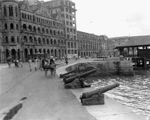
Another note from Rob Weir, clearing up the mystery of which pillbox this was:
I disagree in relation to PB 60 on the posts. [They should be:]
PB 60 - VRC steps PB 61 - No 8 des Voeux Road PB 62 - PO Building Connaught Road Central. PB 63 - Vehicular Ferry Wharf.
He goes on to explain why our initial guess was wrong:
I have a copy of the [Middlesex] map, which I suspect is the one you used, and I can see where the errors crept in. Considering it was done in secret in a POW Camp, I cannot really criticise. As happens with a lot of those documents, they often contradict themselves, or are contradicted by what was written by another unit.
The positions I have [given above] are from the Hong Kong Interim Defence Plan 1939. This was, to my knowledge, the first and only plan made subsequent to the decision to hold only the Island. It is the planning document for the defence of HK and NT, done by senior military staff officers in conjunction with civilian authorities and government officers. As such, I think it is about as accurate as we are going to get. [Those positions] also have 6 digit map references for each.
Thanks to Rob for clearing this up. We'll have to keep an eye out for photos of 60 & 61.
PB 62 is hiding in plain view, distracted by reference to another structure.
If you zoom in using the picture in the post on PB 60 dated 2008-10-30, look at the young ladies walking towards the camera, on the left of the rickshaw. The head of the third from the left of the group partially obscures one of the loopholes. A second is visible to the left of the rickshaw riders helmet. PB 62 had three loopholes, and an airshaft (white) is visible on the roof. For some reason, this PB had no Commanders Turret.

Comments
Not a pillbox?
I received an interesting email about this. First there is another photo of the area, but this one taken in 1945:
You can see the same low concrete structure in the background, but this photo gives a better view of where it was in relation to the sea and the GPO building.
Second, the writer wonders if it was a pillbox at all:
I don't think it was a pen shelter. The couple of photos we've seen of them show they are clearly made from bricks, but this structure looks more like the solid grey concrete we've seen on other pillboxes.
Also, in photo 22 you can see an opening, whereas the pen shelter walls are solid. That opening looks like a pillbox loophole, but unfortunately neither photo gives a clear enough view to be sure.
I still lean towards it being a pillbox, but we'll have to mark it a 'maybe' until we can find a better photo, or other evidence.
MrB
Pillbox 60
There's a slightly larger copy of the photo with the cannons here. The larger photo shows it more clearly, and confirms it was a pillbox.
MrB
Pillbox 62
Another note from Rob Weir, clearing up the mystery of which pillbox this was:
He goes on to explain why our initial guess was wrong:
Thanks to Rob for clearing this up. We'll have to keep an eye out for photos of 60 & 61.
MrB
RE: Pillbox 62
Thanks 80s kid for the link.
If the date is correct, by 1949, Pillbox 062 had been removed as seen here
Notes
Year completed is: Approximate
Condition at last visit: Demolished
Date of last visit: Jul-1998
Ref: ROB-00667
Other:
PB 62
PB 62 is hiding in plain view, distracted by reference to another structure.
If you zoom in using the picture in the post on PB 60 dated 2008-10-30, look at the young ladies walking towards the camera, on the left of the rickshaw. The head of the third from the left of the group partially obscures one of the loopholes. A second is visible to the left of the rickshaw riders helmet. PB 62 had three loopholes, and an airshaft (white) is visible on the roof. For some reason, this PB had no Commanders Turret.