Current condition
Demolished / No longer exists
Unfortunately I can't pinpoint an exact location for this place. An email sent to Shatin District council has solicited only vague details, and I can't seem to find anything on the web. According to a very helpful Jadee Bow at the Shatin District Council, they have no exact location because it was probably bulldozed during the development of Shatin town centre and the widening of Tai Po Road. Another council member recalls that it was on Tai Po Road near Lek Yuen and Wo Che (both now turned into Govt housing estates). There is still a remnant of the fifties still in the vicinity - the Lung Wah Hotel, a locally famous pigeon restaurant, which opened in 1951 - which is on the north side of the road (and thus escaped redevelopment).
Photos that show this Place
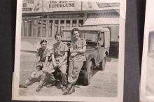
1953
1955
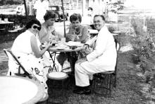
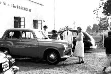
1955
Comments
9 Miles Point
Hi Phil,
Ron's menu gives the address as "9 Miles Point, Tai Po Road".
Looking at a 1902-3 map of the area (Plate 5-2, Mapping Hong Kong) there's a Milestone #9 just where the Tai Po Road crossed the river:
[gmap markers=small bred::22.377415898306324,114.17900347718387 |align=Center |zoom=15 |center=22.377579262668156,114.17876243591309 |width=450px |height=350px |control=Small |type=Map]
I wonder if that's the spot?
Something else I just noticed is that on these old maps the milestones were numbered to increase as you travel from Kowloon through Shatin towards Tai Po. In maps from the 1960s the milestones have been moved, and are numbered to increase in the opposite direction.
Regards, David
#9 milestone
Given the address now I'd say your guess is more valid than mine David. However, are we sure it was exactly on the milestone? Also do we know when it closed? I have an aerial photo of that exact same area in 1970 and can't see anything that would obviously be the Roadhouse.
I have another shot taken in 1960, of the area where Lion Rock Tunnel Road crosses the river, and there is a white single storey building on the corner where it intersects with Tai Po Road - the detail isn't enough to say for certain but if that is the building then that would put it about half way between my guess and # 9 milestone (basically where Hilton Plaza stands today).
if it sheds any light on
if it sheds any light on dates, my friend heidi lived in shatin from 1970-75, she didn't remember it and asked her mother who also had no recollection.
i remember it, so it was still standing in 67 with stone tables out back looking over the bay
Shatin Dairy Farm Restaurant
Hi Phil,
Here are the relevant sections from the book, to see if they help:
[They drive from Kowloon along Tai Po Road, past Kowloon Reservoir, and descended to Sha Tin/]
We drove along the shore until my mother's eye alighted on a small isolated building ahead between the road and the sea wall, surrounded by paper bark trees. It had an awning and a few car parking spaces. but little else.
[...]
The Sha tin Dairy Farm Resturant (aka The Shatin Roadhouse) was a small American-style diner with considerable pretensions. [...] We sat at a table overlooking the inlet. [...] On the other side of the inlet, a cluster of ancient houses stood between woods and the water's edge. A junk sailed sedately but slowly by, heading for the open sea.
After reading that again, the #9 milestone seems too far back from the harbour, so somewhere further along towards your original marker seems more likely.
A 1979 map shows the area already reclaimed, so with Vanessa's help it looks like it disappeared around the early 70s.
Re: Approximate location of Shatin Dairy Farm Restaurant
Hi there,
I guess we could use another landmark to estimate the previous location of the Shatin Dairy Farm Restaurant. Why not use the Shatin Inn Restaurant, which is on 7.5 milestone as a reference? Shatin Inn still exist today. All we have to do is to trace the original Tai Po Road from that. I guess if we measure it correctly we shouldn't be off the mark that much.
Best Regards,
T
Re: Approximate location of Shatin Dairy Farm Restaurant
Thomas, that's worth a try. By your calculations, where would that put the 9-mile location?
Regards, David
I just tried this (granted
I just tried this (granted using an old 1936 map on the Shatin District Cuncil website as reference) and I may be wrong but it looks as though the current highway follows a fairly similar route to the old road.
Adding on 1.5 miles to the Shatin Inn location gives me a position approximately infront of Shatin Tsung Tsin School. Not too far away from the original guess. Does anyone get any better measurements?
Re approximate location of Shatin Dairy Farm Restaurant
Hi David,
My attempt using Google Earth to plot 1.5 Miiles from Shatin Inn alone old Tai Po Road brought me slightly North of Shatin Railway Station, behind Lik Yuen Estate. Lik Yuen Estate was built on reclaimed land as far as I could recall.
I am uncertain of Google Earth's Path measuring tool is accurate or not, however, but some section of Tai Po Road is off-limits to pedestrians nowadays so walking along it is out of the question.
My 2 cents,
T
Lek Yuen Estate
Thomas, the school I hit is also in front of Lek Yuen estate, so I wonder if this is a better place for the original marker?
Maybe Vanessa can remember if there were any local landmarks on the other side of the road that may still be around? For example, 10000 Buddha Temple pagoda was probably visible from this (new) location and perhaps even the Lung Wah Hotel just up the road a hundred yards or so. Both were definitely around in the late 60's. (possibly even West Forest Monastery - down the hill from 10000 Buddha Monastery - which I believe was quite a popular spot for a while).
Re: Approximate location of Dairy Farm Restaurant
Folks,
I've found the following table in the Chinese version of Wiki concerning Taipo Road. It mentioned to modern day Lung Wah Hotel is located in 9th Milestone. According to their homepage they started before WWII. So I guess it make sense there was other similar establishments in the neighbourhood.
Lung Wah is not very far away from Lek Yuen Estate. Actually it's in the original Lower Wo Che village, right opposite Wo Che Estate.
My 2 cents,
T
名稱/Location
咪數/milestone
地區/District
備註/Remarks
尖沙咀天星碼頭
Tsimshatsui Star Ferry
起點
Starting point
尖沙嘴
Tsimshatsui
不屬於大埔公路範圍
Non-Taipo Road
加士居道
Gascoigne Road
一咪
1 Mile
油蔴地
Yaumatai
不屬於大埔公路範圍
Non-Taipo Road
亞皆老街
Argyle Street
兩咪
2 Miles
旺角
Mongkok
不屬於大埔公路範圍
Non-Tapo Road
長沙灣道
Cheong Sha Wan Road
兩咪半
2.5 Miles
深水埗
Shamshuipo
大埔公路(大埔道)起點/Starting point, Tai Po Road
欽州街
Yam Chow Street
三咪
3 Miles
深水埗
Shamshuipo
青山公路(青山道)起點/Starting point, Castle Peak Road
琵琶山
Piper’s Hill
四咪半
4.5 Miles
琵琶山
Piper’s Hill
沙田嶺
Shatin Range
五咪半
5.5 Miles
沙田嶺
Shatin Range
大圍站
Taiwai Railway Station
七咪半
7.5 Miles
大圍
Tai Wai
龍華酒店
Lung Wha Hotel/Restaurant
九咪
9 Miles
龍華酒店
Lung Wah Hotel
崇基學院
Chung Chee Colleage
十一咪半
11.5 Miles
馬料水
Ma Liu Shui
香港生物科技研究院
The Hong Kong Institute of Biotechnology Ltd
十二咪
12 Miles
馬料水
Ma Liu Shui
松仔園
Chung Tsai Yuen
十四咪半
14.5 Miles
大埔滘
Tai Po Kau
Lung Wah
Well, if this is correct then that would put the original guess as almost on the mark. But again, I wonder if the Lung Wah is at the actual 9 milestone point or if it was in the general area of the milestone - give or take a few hundred yards.
Shatin Roadhouse
Notes from HKI:
I've seen a map from 1956 which gives the location of the Shatin Roadhouse. It was opposite Sheung Wo Che - across the railtracks from the Sin Tin To Home for the Aged ( built in 1948 and still there). So that makes the location about 200m SW of the current Shatin Police Station towards New Town Plaza.
The map ref. is C-146-NW-A 1956
Rgds,
HKI
Shatin Roadhouse
That sounds very close to where we got when we added 1.5 miles onto the 7.5 milestone last year. I've moved the pointer to infront of the school opposite the old people's home.
Shatin Roadhouse
After Fred posted this 1950s photo:
and IDJ posted this aerial view from 1964:
I went back to the 'Mapping Hong Kong' book, and with the help of the photos found the roadhouse is shown on this map:
Just above the "Sh" of Sheung Wo Che there's only one building shown on the seas side of the road. That must be the Dairy Farm building.
A little way south-west along the road we can see where the road does a kink as it crosses the bridge shown in the two photos above. And behind the bridge are the Pai Tau Village houses shown in Phil's photo:
Good to have it all tidied up - thanks for everyone's help.
Regards, David
Great photo, thank you for
Great photo, thank you for your share and hope following information can be help to found the exact location of Shatin Roadhouse....
http://www.uwants.com/viewthread.php?tid=15184666&page=14#pid208729047
http://www.uwants.com/viewthread.php?tid=15184666&page=15#pid208752283&…;
Sheung Wo Che 上禾輋
Ha Wo Che 下禾輋
Pai Tau 排頭
償還
http://www.uwants.com/viewthread.php?tid=15184666&page=15#pid208776147
:o)
Shatin road house aka dairy farm rest
I frequented there circa 70 to 72. Ran by Mr. KWOK
It has a Shell gas station attached. Same ownership.
His older son moved here in vancouver.