Not certain but this could be the Bridge over the Albany Nullah. Perhaps Macdonnell Road as David says. If it was Bowen Road, I guess Union Church would have been further in the distance.
(edited later) Yes, Moddsey is right, that is the bridge over the Albany Nullah - I thought it was at "Bowen" Road, but it is at MacDonnell Road (I checked the map)
Back then, there was a hairpin at the top of Garden Road, with Bowen Road joining there (have a look at the 1901 Map).
Hi Marlowe, I'll have another go at convincing you it's Macdonnell!! If you look at the two photos above, at the western end of the bridge is a building. Thanks to your photo, we can get a good idea of its outline.
On sheet 12 of the 1901 Map, we can see a building with the same shape next to the Macdonnell road bridge. I don't think we can see the Bowen Road bridge in your photo, as it is too low and so hidden down behind the filter beds' wall.
As the nullah passes under the Bowen Road Bridge, it: - makes a slight kink to the east as it passes under the bridge - may change width, if the map is that detailed - runs downhill roughly in a north direction
As the nullah passes under the Macdonnell Road Bridge, it: - runs straight - keeps the same width - runs downhill roughly in a northeast or east direction
The first photo seems to fit the Macdonnell description better, especially with the view looking east down the harbour. If it is Macdonnell, I've no idea how the postcard got its name!
Ok, I'm convinced, the picture is MacDonnell Road.
I got the maps from 1901 and 1964, and drew lines from each of these points, through the Union Church to see what should be in the background.
1) From MacDonnell Road, it passes through the hillside to the right of Kennedy Road, with East point and Causeway Bay visible behind.
2) From Bowen Road, to the left and out to sea, East Point woukd not be visible.
As to why it says Bowen Road? I guess that they hadn't named MacDonnell road yet, so they gave the name of the nearest road.
I found this reference online;
The Officer Administering the Government recommends the Council to vote a sum of Fifteen thousand Dollars, ($15,000), being amount required to be expended in this year, as part of $38,000 estimated, for training Albany and adjoining Nullahs, and opening up the land now available as building sites between the Bowen and Kennedy Roads.
some of those postcards are just plain wrong. There is one of Idlewild on Seymour Road that says "Caine Road". Hey, they were for toursits to send home .. accuracy was not crucial.
The bridge is half way up, and a third of the way in from the left.
3 feet to the left of the road is a line of stonework, that is the edge of the bridge, you can see the arch below, and the wall of the nullah to the left.
The building to the right is in the Botanic Gardens I believe.
I'm pretty sure the "arches" in the top right are retaining walls (I can see 4 bridge like things)
there will be a couple of big houses on the other side of the roadway in the background, (usually referred to here as "pre-estoril court") so there will be substantial earthworks.
To complement Marlowe's recent photo of the Macdonnell Road Bridge:
Here is another shot of the Macdonnel Road as well as the Kennedy Road Bridges from a different angle and cropped from http://gwulo.com/node/4953. St Joseph's Church can also be seen.
Comments
Standing near the top of Garden Road?
I'll guess the bridge is Macdonnell Road, with the Kingsclere construction site beyond that, and Union Church in the background.
Regards, David
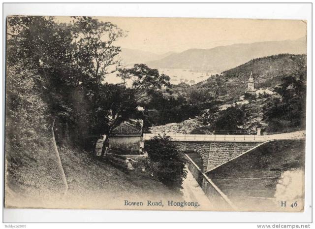
Bridge over the Albany Nullah
Not certain but this could be the Bridge over the Albany Nullah. Perhaps Macdonnell Road as David says. If it was Bowen Road, I guess Union Church would have been further in the distance.
Bowen Road
(edited later) Yes, Moddsey is right, that is the bridge over the Albany Nullah - I thought it was at "Bowen" Road, but it is at MacDonnell Road (I checked the map)
Back then, there was a hairpin at the top of Garden Road, with Bowen Road joining there (have a look at the 1901 Map).
Re: Bowen Road
Marlowe - First time I have seen the Bridge from above. Thanks for the confirmation.
Bowen or Macdonnell ?
Hi Marlowe, I'll have another go at convincing you it's Macdonnell!! If you look at the two photos above, at the western end of the bridge is a building. Thanks to your photo, we can get a good idea of its outline.
On sheet 12 of the 1901 Map, we can see a building with the same shape next to the Macdonnell road bridge. I don't think we can see the Bowen Road bridge in your photo, as it is too low and so hidden down behind the filter beds' wall.
Or are we talking about two diferent things?
Regards, David
Compare the height of the two
Compare the height of the two bridges. I think the one in this photo is too short to be the Macdonnell Road bridge.
Bowen or MacDonnell?
(edited later) David, yes you are right, that my picture from the peak, is of the bridge at MacDonnell road.
It begs the question; if it's not Bowen Road, why does it say so on the postcard.
Alun
Here is the Macdonnell Road
Here is the 1901 map showing both bridges, a little building next to the Macdonnell Road bridge and Union Church (top right)
Bowen / Macdonnell
Alun, the map gives a couple more suggestions.
As the nullah passes under the Bowen Road Bridge, it:
- makes a slight kink to the east as it passes under the bridge
- may change width, if the map is that detailed
- runs downhill roughly in a north direction
As the nullah passes under the Macdonnell Road Bridge, it:
- runs straight
- keeps the same width
- runs downhill roughly in a northeast or east direction
The first photo seems to fit the Macdonnell description better, especially with the view looking east down the harbour. If it is Macdonnell, I've no idea how the postcard got its name!
Regards, David
MacDonnell Road
Ok, I'm convinced, the picture is MacDonnell Road.
I got the maps from 1901 and 1964, and drew lines from each of these points, through the Union Church to see what should be in the background.
1) From MacDonnell Road, it passes through the hillside to the right of Kennedy Road, with East point and Causeway Bay visible behind.
2) From Bowen Road, to the left and out to sea, East Point woukd not be visible.
As to why it says Bowen Road? I guess that they hadn't named MacDonnell road yet, so they gave the name of the nearest road.
I found this reference online;
The Officer Administering the Government recommends the Council to vote a sum of Fifteen thousand Dollars, ($15,000), being amount required to be expended in this year, as part of $38,000 estimated, for training Albany and adjoining Nullahs, and opening up the land now available as building sites between the Bowen and Kennedy Roads.
Government House, Hongkong, 12th July, 1890.
some of those postcards are
some of those postcards are just plain wrong. There is one of Idlewild on Seymour Road that says "Caine Road". Hey, they were for toursits to send home .. accuracy was not crucial.
A view from below
And here's a view of the bridge from below.
Alun
Where's the bridge? All I
Where's the bridge? All I see is the road along the houses of "upper" Macdonnell Road - now Estoril Court.
Are you refering to the building with the arch lower right ? If so it is much higher in elevation than Macdonnell Rd.
Find the Bridge
The bridge is half way up, and a third of the way in from the left.
3 feet to the left of the road is a line of stonework, that is the edge of the bridge, you can see the arch below, and the wall of the nullah to the left.
The building to the right is in the Botanic Gardens I believe.
Re: Bridge
In your photo, it looks like there is another bridge on the top extreme right with an arch.
Retaining walls
I'm pretty sure the "arches" in the top right are retaining walls
(I can see 4 bridge like things)
there will be a couple of big houses on the other side of the roadway in the background, (usually referred to here as "pre-estoril court") so there will be substantial earthworks.
Re Macdonnell Road Bridge
To complement Marlowe's recent photo of the Macdonnell Road Bridge:
Here is another shot of the Macdonnel Road as well as the Kennedy Road Bridges from a different angle and cropped from http://gwulo.com/node/4953. St Joseph's Church can also be seen.
Bridge at Kennedy Road
Good shot of the MacDonnell Road bridge, and also the bridge at Kennedy Road,
Alun