Current condition
Ruin
Martin Booth mentions this range a couple of times, as part of his walk along Harlech Road:
[...] passing a waterfall, and arriving at the place where the soldiers lay down to shoot across a valley at the butts.
I'm not 100% sure where the shooting platform was, but I'll guess it's here for a couple of reasons:
The road round the Peak is narrow, except for this area where it becomes much wider. It has several exercise stations on it now, but maybe this flat area was where the soldiers "lay down to shoot"?If you look at the wall in the butts area (visible in the satellite view, draw a line through the center of the wall at right angles to it, and project it back, it hits the road around here.
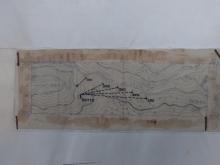
James has since found this map that shows there were several shooting platforms, slightly below the level of the road. There is more information in the comments below.

Photos that show this Place
1907
1946
1946
Comments
Murder on the Peak
In Booth's description of walking around the Peak he writes:
The 2 Jan 1954 edition of The China Mail reported the murder on its front page, saying that the murder happened on New Year's Eve.
Re: Rifle range on the Peak
Hi there,
Just curious. Google Earth's ruler function showed the distance between the proposed location and the 'Butt' is roughly around 400 Metres. I wonder what would be the effective range of British Post WWII rifles are. Or, would grunts be able to shoot from that far away with a certain degree of accuracy? Anyway I do not have any experience on firearms so it would be impossible for me to say. Do we have any marksman around who would enlighten us a bit please?
T
Effective Range of Post WWII British rifles
Hi there,
After googling around a bit I found this piece of information:
http://militaryhistory.about.com/od/smallarms/p/leeenfield.htm
Apparently Pre WWII rifles in use by British forces are already having an effective range of some 550 yards. That's roughly 500 Metres.
This being checked-up the location make sense.
T
Shooting platforms
Moddsey found that, at least originally, there were several places for soldiers to fire from:
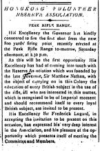
1906 PWD Annual Report
At the request of the Volunteer Reserve Association (Hong Kong Volunteer Corps), a new rifle range was constructed at the Peak. The butts are situated on the eastern slope of High West and the firing points below the Harlech Road, at ranges 200, 300 400 and 500 yards. The targets which were obtained from England, are of Jeffries' Patent 'Wimbledon' type and a small building has been constructed for them when not in use. The range was finally handed over to the Association in October.'
In later years rifle practice was conducted once a week at the range.
I think the point should be
I think the point should be moved a bit to the left.
http://www.openstreetmap.org/?lat=22.27221&lon=114.14185&zoom=18&layers…
I was up there poking around last week and found a small overgrown path with old concrete stairs leading to it. I could see no good purpose for it. But now that I've looked at this discussion, I'm fairly certain that it is the platform.
I will try to go back this Saturday and take a few pics and explore further.
HK Island shooting range
Don't know much about the Peak range but as a kid, I remember a pistol range on Kennedy Road. I recall seeing some HK policemen shooting their revolvers on a raised platform with a set of stairs much like the one described here.
The other shooting range I am aware of on HK Island was located at Standley Fort.
Volunteer Firing Range Platform
Don't know the location. Photo of HKVDF Shooting Practice.
Kennedy Road Shooting range
They built the electricity substation over the top of that, which was elevated, so they could still shoot there.
I remember when the range was in use, there were red flags on Bowen road, warning you not to go near the edge.
Alun
Re: HK Island shooting range
Hi there,
They used to have one in the Wong Chuk Hang Policy Acadamy, however I believe it had been removed somewhere else in the 1980's.
Best Regards,
T
Location of firing platform
Hi Tony,
I'll leave the marker alone for now - there were several locations, so this is just a generic marker in roughly the right area.
I'd also noticed that path, and wondered what it was for. The 1906 note moddsey found describes the platforms as "below the Harlech Road", so the path could well lead to the platforms. Looking at the b&w photo, there is a large flat area for the soldiers to shoot from. Any sign of an area like that off the path?
Here's another mention of the area from 1907:
Regards, David
Shooting @ Wong Chuk Hang
Hi T,
A couple of times in recent months I've been hiking around the hills on the south side of the island, and heard what I assumed was gunshots from the direction of the police academy.
And late last year another hike took us past the old quarry near Jardine's Lookout. They had a machine to launch 'clay pigeons', and policemen were taking it in turn to fire at them with a shotgun. Hopefully they were new recruits, as there weren't many fatalities among the pigeons that day!
Regards, David
re firing range
looks like the area now occupied by a park off Harlech Road, next to junction with Lugard Road. isn't it same place where Tyndareus Stone was? https://picasaweb.google.com/Colin.Aitchison7/BritishArmyInHongKong#5514826104468126754
Re: Shooting @Wong Chuk Hang
Hi there,
That means they are still shooting at the acadamy. As far as I could recall only revolvers are involved there. Back in the 1970's you could stand across the nullah and watch. The cadets would be shooting towards the west on a lawn around 50 metres away from the fence next to the nullah.
Best Regards,
T
Yards
The amateur marksmen of the Hongkong Rifle Association were shooting targets at 600 yards as far back as 1868. (China Mail, July 20, 1868. p3)
I was back up at the peak
I was back up at the peak this weekend following the trail I had discovered earlier. The cool weather and the lack of mozzies allowed me to stay up there a while and explore.
I found the trail was longer then originally found and I've updated Openstreetmap to show the full lenth of the trail that I could find.
I also found the following along the trail:
1) there is a stone/concrete platform at about 200m away from the butts. Its suitable for a few guys to do some standing up target practice.
2) there is another stone/concrete platform, wider than the first at about 300m away from the butts. Its suitable for a few more guys to do some standing up target practice.
3) there is an area of clearing at about 400m away from the butts suitable for several men to lay down and practice. This clearing is just due south of the west end of the playground.
Lastly, I measured the east end of the playground and it seems to be right about 500m away from the butts.
I'm sure a good metal detector would be able to turn up some interesting finds in these areas.
TonyB
Re: Shooting Platforms near Harlech Road
Hi there,
I believe the path is visible on the Government 1:10,000 street maps. Base on the index, it would be on sheet 7 SW, available in all mape sales outlets. The current version is dated July 2010.
BTW, did you take any photographs when you were on the Peak earlier?
Best Regards,
T
I took a number of photos
I took a number of photos while up there but none of them were particularly interesting so I didnt bother uploading them.
You are right about the mapping of the paths. I can see them on map.gov.hk as well.
Re: Shooting Platforms near Harlech Road
Hi there,
I was on the High West about two years ago, about 1/3 up the path behind the Butts. I was unable to see any platfroms from that location. I would say the locations had been overgrown. Even The Butts has a line of trees in front of it nowadays.
Were you able to see The Butts and the hut from the platform?
Best Regards,
T
See The Butts? you've got to
See The Butts? you've got to be joking *smile*
You could not see anything at all, not even High West (for most parts). The area is really overgrown and required a lot of work to get thru. Lots of thorny plants that love blood and I did my contribution.
I did quite a bit of clearing though so the next visitor wont have as much difficulty.
Re: Shooting Platforms near Harlech Road
Hi there,
Ah, understood. I have only crashed through one such disused path above Tien Wan a few months ago. I know what you mean. Except for thorn you might come in face to face contact with cobwebs...... I guess we were lucky not to stumble on any bee hives or ant hills around...... Or Snakes.....
Best Regards,
T
Shooting platforms
Hi Tony, Glad to hear you've tracked them down. I'll have a scramble around and follow your footsteps next time I'm up there.
Regards, David
Re: Shooting Platform near Harlech Road
I had noticed the concrete rectangular platforms on the path beneath Harlech Road when I went looking for the Rifle Range in 2009. Did find an old lamp post on the same path though.
Had taken a photo of High West but not of the lower slope.
Shooting platforms
Looks like the same island in the background of Moddsey's colour photo as in the old B&W photo above. Is it Cheung Chau?
Regards, David
Should be Lamma Island.
Should be Lamma Island.
Re: Should be Lamma Island?
Hi there,
I tend to differ as Lamma Island is much toward the South West, a little bit more towards the South. If you are up at Harlech Road or at one of the platforms looking toward the High West and then towards the southern ridge of it, you would be looking towards WSW, very much toward the West more than South. If you consult a Map it should show Hei Ling Chow in the foreground, with Lantau at the back.
Anyway, a site visit is in order for this as sometimes maps could not be read in such details unless you have a good one. The on-line ones are not as good.
Best Regards,
T
Group expedition?
Reading the comments of different people exploring for this rifle range and trying to relay details here to others, just wondering if you guys have ever considered a group expedition? Sounds like there are a number of people interested and might be fun to pool the efforts and explore together.
Re: Group Outing?
Hi there,
It does not necessarily be a group outing. All we need is a clear day that one of us could take a few photos with the approximate direction, maybe just atop the Peak Galleria towards the west.
We would need a very hot and sunny day just for the view though.
Best Regards,
T
rifle range
Hi
In the 1950s when I was a boy (I lived on Lugard Rd) I would go to the platform with my friend (but sometimes alone) and the soldiers would let us/me watch them shooting as long as we stood well back - also when they practised with Bren guns; I think they were often Ghurkas as well as other troops. I would collect the spent cartridges that'spilled' over the platform ... and then when the soldiers were gone I would go to the targets across the valley (there was a rubble screed on the slopes of High West) to collect and look for lead (pb) bullets - which usually were flattened or distorted but sometimes there was one that was relatively the same shape as before it was fired! I once went back to the platform and we found a live round, it looked beautiful as well as ominous - we desperately wanted to keep it of course; but good sense prevailed and I handed it back to the sergeant-major the next day - receiving much praise (I was a good little cub scout afterall! in 36th HK Pack associated with St John's Cathedral)
happy trails
Peter
Empty cartridge cases
As a boy I lived on Lugard road between 1956 and 1960 and remember going to watch the Army at the firing range with friends. I recall once being allowed to hold a rifle at the firing platform and thinking how incredibly heavy it was! I collected loads of .303 cartridge cases over the years ( I've still got one) as well as clips and empty ammunition boxes. I also remember searching for the spent bullets in the hillside behind the target and trying to insert any vaguely straight ones into the cartridges!
David.
cartridges
Hi David
If you were also collecting cartridges there and lived on Lugard Rd during that time, chances are we knew each other - are you the David from the GEC Apts? You had an elder brother called Mark who was already at school in UK?
How amazing ! Do you still live in HK?
best wishes
Peter
cartridges
Hi Peter,
Definitely sounds like me! Did your family live in the house just below the GEC appts on the other side of Lugard Road and have a rather large Chow dog? If so I'm sure I've got a photo of us at Mark's birthday party taken Sept 1958 or 1959. I left HK in 1963 and unfortunately haven't been back since; now in UK.
Best Wishes.
David.
cartridges2
Hello David
Yes, we lived opposite GEC Apts on the downhill side at #31 My family had the top floor apt - we lived there from approx 'mid 54 to Feb '59 when we left HK for Oz (where I am now - again!)
We didn't stay there long though, returning to Dad's native Holland in mid '60 where I subsequently went to school and university.
First there was a French family (which my Dad was somehow associated with, business-wise, not sure how) then there was a Dutch family living in the downstairs apt at #31 - they had the large chow dog, which I recall always went missing!
Would like to see that b/day party photo sometime if you can scan it and work out a way to post it !
When I go back to visit, I have been stopping over in HK on my way to/from Holland since 1984 - always fly Cathay from HK to Amsterdam! That's when I first went back to Lugard Rd - it's still always a buzz to revisit old haunts like the rifle range, High West, Peak School etc (for some reason I never make it to the LRC though - I assume it still exists!)
My best wishes to Mark
happy trails
Peter
find the plan of Rifle Range
I find the plan of. High West Rifle Range(1950) HKRS156-1-576
Good Find
Good find. What is the date of the map?
A quick search of the opening date of the Peak Rifle Range is 3 November 1906.The Hong Kong Weekly Press dated 12 November 1906 refers.
it seem to halt B4 war II and reused after 1949
it seem to halt B4 war II and reuse after 1949
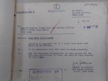
attached permit dated 8 MAY 1950 to 31 DEC 1950
HKRS156-1-576 (5.7.1946 - 7.12.1963)
Re: Map of High West Rifle Range
Hi There,
I had been wondering why there are more than three marked foot paths (all those concrete blocks or traces of foot paths on the side) going down. I guess there is probably no chance for a natural bush fire in the area so we could see them unobstructed....... Maybe..... maybe someone with a very deep pocket hiring a chopper with lidar?
T
more Plan for high West Rifle Range
Gazette No 1185 draft
MEMO for members of Urban amenities select committee- 1963
re: find the plan of Rifle Range
That's great to see exactly where the platforms were. Thanks for sharing these finds with us.
Rifle Range
Forgive my pedantry, but the correct military terminology for the place where the soldiers actually fire their weapons is "firing point." I'm assuming where the phrase "shooting platform" is used, this is to what people are referring?
Detection of Peak Firing Range Murder
The two newspaper articles below from May 1954 report the detection of what surely must be the murder on the Peak Firing Range mentioned in Chapter 7 of “Gweilo” (aka “Golden Boy”). The case occurred on New Years Eve 1953, but was initially undetected - see the article copied near the head of this string.
The May articles reveal that, nearly six months after the case occurred, a man had been charged with the crime, had appeared in Magistrates Court twice but had not yet been committed for trial. Only details of the victim and accused, together with the time, date and location, were mentioned in the articles, but the one of 27th May quotes defence counsel referring to, “the special circumstances of this very abnormal case…”. It sounds interesting.
I’ve looked for, but can’t find, subsequent English newspaper coverage of the case. Does anyone know the full facts and how it ended?