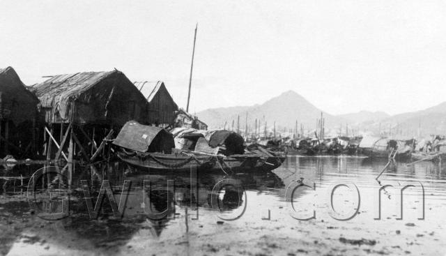
Where: Any ideas? The location isn't written on either the front or back of the postcard, but I'm hoping someone can recognise it. The conical hill in the background looks like the most obvious landmark - hopefully that will trigger someone's memory.
Maybe it wasn't even taken in Hong Kong, but fingers crossed it was.
UPDATE: Thanks to reader J, who has identified the location:
I thought this looked more like Kowloon Peak when viewed from Shau Kei Wan / Aldrich Bay. That faint mound behind the peak and to its left would then be Tate's Cairn and somewhere just below the ridge line is where Jat's Incline and Sha Tin Pass Road meet today.
What: There's a harbour full of sampans, and the masts in the distance suggest there are larger sailing boats in the harbour too.
It looks as though the photographer was on the shoreline, looking across mud to the water. There are buildings on stilts too - could it be Tai O?
Who: Good question - there's no sign of anyone.
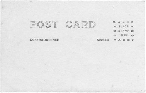
When: The date is approximate, but in the right ballpark as we can be sure it was printed sometime between 1918 and 1930. The clue isn't in the picture above, instead we need to turn it over and look at the back:
It's what's known as a "Real Photo Postcard", or RPPC. The front picture was printed using a photographic process, and the back of the photographic paper had postcard markings pre-printed on it.
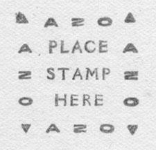
Next look at the Stamp Box:
We can see they used Kodak's "AZO" paper, commonly used for contact printing this type of postcard. Next by the wonders of the internet we find there were several different versions of this paper, identified by the symbols in the corners of the box. We've got the "Two triangles pointing up and two triangles down" variety, listed as in use between 1918 and 1930. I've guessed a date somewhere in the middle.
Regards, David
Reference: C001 (previously: PC01E)


Comments
Re: c.1925 Sampans, but taken where?
Hi there,
I wonder if the conical hill would be Nam Long Shan (南朗山)﹐ were present day Ocean Park resides. It look conical from Google Map to me.
http://goo.gl/maps/FhPa
If that is the case the location of the photographer might very likely be someware between Tin Wan (田灣) and Gai Lung Wan (雞籠環), at one of the old beaches around the area. Gai Lung Wan had been reclaimed together with a pillbox or two where present day Wah Kwai Estate is located.
Google map shows the coast there was (and still is) having a straight line with Nam Long Shan.
I might also be Tuen Mun as Ching Shan is also sort of conical.
I will check up Nam Long Shan over the weekend.
Best Regards,T
1925 Sampans
Tuen Mun/Castle Peak
Aberdeen? Tuen Mun?
Gentlemen, thanks for the input.
Aberdeen was certainly a favourite location for sampan postcards. Here's a photo looking roughly the direction you describe. The skyline doesn't match here, but maybe will from a different angle.
Tuen Mun I don't know well enough. Are you suggesting photographer on Gold Coast side of Tuen Mun, looking west towards Castle Peak?
Regards, David
Aberdeen? Tuen Mun?
David
I'm basing my supposition on the far ridge line in the added photograph "Tuen Mun-1983". This ridge line is up the Castle Peak valley with the mountain generally known as Castle Peak off to the left. The far ridge line at the right hand side continues rising up behind the tower blocks of flats. At the time your postcard is dated, water access in Castle Peak Bay extended very much further up the valley than it has done since the 1950s. I would place the photographer somewhere on the original 1925 shoreline near central Tuen Mun where Pui To Road leads off at the present day. There are old images of the bay with similar shacks on stilts and numerous sampans and Junks. Unfortunately not taken at the same angle. I am willing to be corrected however!
1925 Sampans
It looks very much to me like Castle Peak in the background. I suspect this photo was taken in Castle Peak port, possibly in the vicinity of "Mouse Island". This area was used years ago by the fisherfolk to abandon their still-born or unwanted offspring, it thererfore crawled with rats, hence the name.
Mouse Island area still hosted a big wholesale fish market in the 1990s, probably still does, and there was a small floating resaurant for the use of fishermen and their families
Judging by the very large number of boats in harbour, this picture was probably taken around Chinese New Year.
Kowloon Peak?
I thought this looked more like Kowloon Peak when viewed from Shau Kei Wan / Aldrich Bay. That faint mound behind the peak and to its left would then be Tate's Cairn and somewhere just below the ridge line is where Jat's Incline and Sha Tin Pass Road meet today.
Kowloon Peak
J looks like you're spot on. compare with this photo here
http://maps.google.co.uk/maps?ll=22.287617,114.222751&spn=0,0.009602&t=h&z=17&lci=com.panoramio.all&layer=c&cbll=22.287617,114.222751&cbp=12,0,,0,5&photoid=po-6139299
Thank you!
J, you've nailed it, thanks. Here's another present-day view from Google, that even includes a few sampans for good measure!
Regards, David
I've been meaning to say this
I've been meaning to say this is Aldrich Bay/ Shau Kei Wan since I first saw the post. The view is not dissimilar to the scene from our house on Korn Hill or flat on Finnie Ridge (both sadly now part of the Korn Hill housing estate and landfill for Tai Koo Shing). Glad you got the answer to your question.
Finnie Ridge, Quarry Bay, HK
Hi Geoff,
It's so happy to know that someone still remembers the place Finnie Ridge. Yet sad to have this name disappeared from the map and replaced by Kornhill! A lot of nostalgic memories I have about the place:
For about 15 months during the early '70s, I went up there almost once a week, usually on Wednesday evening. I took the tram from Causeway Bay and got off at the stop nearby the Taikoo Staff Quarters. Then I climbed up by the trail of Finnie Ridge to reach the 3 or 4 storey high apartment building where my guitar tutor and his family stayed. He was a nice gentleman, scottish, Mr. Tom D Hunter, a chemist working at the Taikoo Group. I was about 15 then, and he's very generous to all his students & friends- offering us beers (San Miguel) and sometimes dashes of Scotch! Needless to say that I learned a lot from him, not only the music part (I'm no talent anyway) but able to expand my perspective and values towards life. He retired and returned to Skye with his family in the late '70s.
When I had to go to Kwun Tong during the early '80s, I'd try not to take the MTR nor the bus but the ferry from North Point so that I could stare at the apartment building on Finnie Ridge and traced back the joyful moments I ever had there.
Wonder if anyone has photos of that apartment or of Finnie Ridge to share?
Thanks & regards,
Ramas