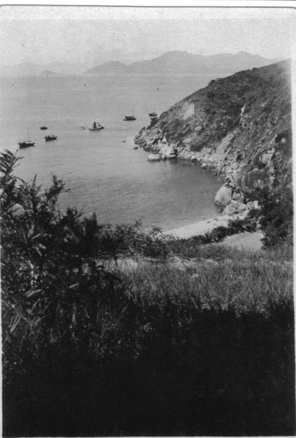
Came across this picture among some family pictures. On the back is written "One corner of the beach only for Europeans on the other side is one for the Chinese".
The handwriting is my great aunt's and I would date the picture to the early to mid 1920s.
Does it ring a bell with anyone and could she have been right?
Date picture taken
1925
Gallery
Shows place(s)

Comments
Cheung Chau Island?
Cheung Chau Island had a European Reservation area.
What do you reckon?
http://www.serasphere.net/dalianpics/cheung_chau_island_13.JPG
Looks like a match
The headland seems to match so guess you are right.
Does the background of my pic place it and where is this island which I assume was a holiday spot in the 20s?
Re: Cheung Chau Island
If you refer to a map of Hong Kong, Cheung Chau Island lies to the south west of Hong Kong Island proper. The island that one sees in the background is the larger island of Lamma and the smaller island on the left could be Kau Yi Chau.
The Cheung Chau (Residence) Ordinance was passed in 1919. The European reservation area was located on the southern part of the island where missionaries had already settled. Out of eleven beaches on the island, five beaches on the southern shores were affected by the Ordinance. There are still some marker stones that demarcate the reservation area.
Cheung Chau Island
Thanks for the wonderfully precise information. Having spent a little longer looking at your picture I am sure you are correct about the location.
I assume that this was a one time popular spot for bathing and general frolics. My great aunt who I assume took the picture because it comes from her collection was a very bright young thing who played hard in 20's HK.
Thanks again.
same rocks
actually, I don't think you need the headland to identify this place, just look at the rocks in both photos and they are a perfect match.
Re: Cheung Chau Island
Another view of the area: http://www.cheungchauhk.com/walking-cheung-chau/southern-cheung-chau-wi…
Afternoon beach
Sean, I've added a Place to the photo to round off Moddsey's identification, so you can see exactly where it is. Another one to add to your intinerary when you visit Hong Kong!
Kwun Yam Beach
When the Cheung Chau Residence Ordinance (European Reservation) was passed in 1919, the main beach for locals was at Tung Wan. It is on the same stretch of shoreline as Kwun Yam Beach.
Taken from the path above Kwun Yam Beach
Kwun Yam beach cheung Chau
The island in the background of the photo towards the right is actually Lamma island.
The area reserved residentially for Europeans was marked out by a series of marker stones - one of which is still visible half-way up the first section of Peak Road on the left (going up) under a tree (one third? way from Jockey Club betting shop and Kuan Kung Temple)
Kwun Yam Beach Cheung Chau
The main island in the background is indeed the south side of Hong Kong island.
The Lamma island, which is quite low-lying, doesn't appear to be in the old photo because the sight of it was entirely blocked by the Fa Peng headland. However, it might be a different story today due to the Power Generation Station, which is built on reclamation land on the west side of Lamma Island. So a small part of western Lamma could be visible in that photo frame.
Tung