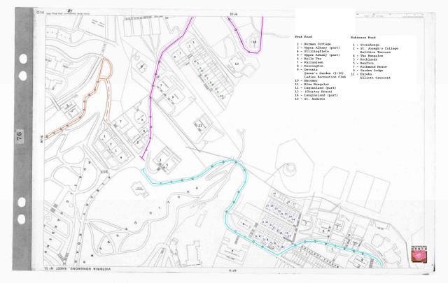
I have taken the PRO map, rotated it, added house numbers and a key to the house names.
Colour code:
Old Peak Road - Purple
Robinson Road - Turquoise
Garden Road - Brown
Key 1901 Map - sheet 12
(Old) Peak Road
2 - Norman Cottage
3 - Upper Albany (part)
4 - Stillingflete
5 - Upper Albany (part)
6 - Belle Vue
7 - Kurranjeen
8 - Derrington
9 - Devonia
Queen's Garden (1-10)
Ladies Recreation Club
10 - Macomer
11 - Blue Bungalow
12 - Luginsland (part)
13 - (Charter House)
14 - Lunginsland (part)
16 - St. Andrews
Robinson Road
1 - Stonehenge
2 - St. Joseph's College
Belilios Terrace
4 - The Bungalow
3 - Rocklands
5 - Benfica
7 - Richmond House
9 - Garden Lodge
11 - Eureka
Elliott Crescent
Date picture taken
1901

Comments
Why rotate?
Annelise,
A very handy reference to have, but I don't see the benefit from rotating the map. That makes it 180 degrees different from every other map we use. I have to make a mental rotation back again each time I look at it, so I can work out where the numbered building is on those maps.
Any strong reasons to rotate the map?
Regards, David
Compare to photos from Harbour
It is just a personal preference.
For me "up" (the top of the map) should be the Peak. I find it more comfortable looking at things that way, because that is the way I always perceived the lay of the land as a child.
re: Compare to photos from Harbour
Aha, that makes sense - whereas I usually turn to maps first.
Thanks for the explanation.