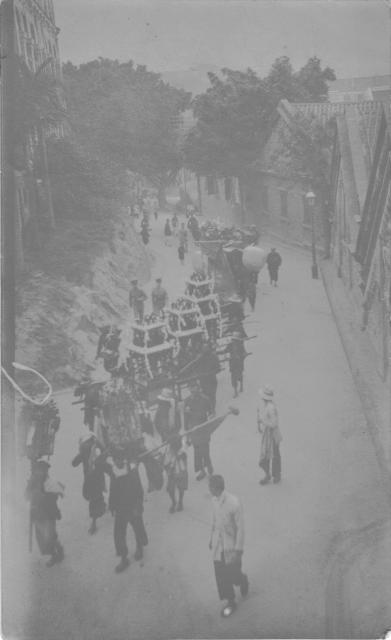
Here's a picture I have just come across at the bottom of a file of family snaps.
Anybody got any ida what it is or where it might be? Sorry about the quality but can't get any more out of it on my primitive pic editor.
Thanks,
Sean
Date picture taken
1900s
Gallery
Shows place(s)
Comments
Initial impressions
The parade looks like a funeral procession. The tall building on the left looks strange and very much like a campanile.
re: parade query
Yes, I'll vote for funeral procession too. Here are photos of some others for comparison.
Here's an adjusted photo. As Moddsey says, the buildings look distinctive, and hopefully someone will recognise them:
And this also gave me an excuse to write up how to enhance faded photos, something that's been on the to-to list for a while.
re: funeral parade
there are some tantalising clues:
the road curves uphill around a slope; there'a a large house on the slope on the left. More importantly, there's a large house on a hill in the far background. I'm guessing it's on HK island, which would suggest the sea and north would be to the right. Presumably the coastline is at least on the other side of the buildings on the right. Hope that helps trigger some ideas.
If it's Kowloon then I'm stuck
re: funeral parade
the telegraph/telephone/electricity wires shown may also help give a date - HK only had electricity and phones after 1890 - as well as the lamp-post design
Re: Funeral Parade
An interesting but very hard photo to identify. Just my thoughts.
The tall tower-like structure on the left could be the campanile of the Roman Catholic Cathedral above Caine Road. The path that leads upslope could be Glenealy which was at the time a popular route to the Mid-Levels. There appears to be sedan chairs waiting to take passengers uphill at the bottom of the path.
Comparison of the tall structure and with the photo below, There are also houses to the right of the campanile.
The house on the bluff may be Government House. Any other ideas?
Campanile
Moddsey, I think you are right with it being a campanile, but the one of the B&W seems to taper as it gets higher, plus I count maybe 6 arches (3 either side of a central recess/feature) across the width which may make it bigger than the one above.
Do you have any other pictures to compare?
Re: Campanile
As the quality of the original photo is rather blur, right now, it is only an assumption that the tower-like structure is a campanile. Other photos of the Roman Catholic Cathedral (2nd generation) can be viewed here:
http://gwulo.com/roman-catholic-cathedral?page=0#comment-11298
re: parade query
In the top-right of the corner we can see the slope of a hillside.
It looks as though the photographer was some height above the road, and maybe that the road runs beneath his feet?
I also wonder if this was the funeral of someone known to the family? You didn't just pull out your mobile phone and take a quick photo then, so was this photo planned?
Parade query
That's a very well made point. This picture was deliberately set up. It is no snap. In those days with glass plates and goodness knows what else it just had to be. I see right at the back a group of mourners and also a car. Can't identify its make.
This could well be a funeral of one of my great grandmother's relations. There is a school of thought in my family that says Ching Ah Fung was a very good marriage for John 1 to make as she came from a rich Chinese background. Does the funeral tell us anything on that?
I also have some pictures of other family members with Chinese people and to my inexperienced eye they do not look like servants. If I can find them I will post them.
Sean
Processions - 1920s
"For reasons no one has ever explained to me, the short Elegant [Elgin?] Street, which branched off from Caine Road downward along a gentle slope to join Peel Street, then on to Staunton Street, appeared to be a popular venue of all sorts of Chinese style processions. We had the very frequent Funeral Processions, the occasional Wedding Processions, the sparing Fund-raising Processions (for flood relief in certain parts of China, etc.) as well as the Religious Festival Processions, notably, the most impressive Chiu Chow Yu Lan Ghost Festival Procession."
http://www.galaxylink.com.hk/~john/paul/memoir2.htm
Processions - 1920s
Hi Annelise,
There used to be many buddhist / taoist nunneries and other traditional Chinese places of worship at and around Staunton Street (apparently at least one of which still exists today). Hence the traditional ceremonies, especially funerals and those relating to the commemoration or worship of ancestors (e.g. Yu Lan).
Also because of this, Staunton Street is colloquially known as "Nun Street" (師姑街) to older locals.
Elgin Street?
Annelise, I thought you'd found it, but looking again it seems the house on the hill in the background wouldn't fit that location. Unfortunately the photo of Union Church on Staunton St has gone from Flickr, or we could have taken a look up Elgin Street from lower down to compare.
Bunce, you've added some interesting comments. Thanks for joining in.
Parade Query
If you zoom in only 30% and from the 2 policemen all the way down(behind them), with the curvature of the road and the incline my best guess would be it's Wyndham Street
Parade Query
From the uniforms, presuming the date is correct, I think they are more likely to be soldiers. Might that be significant?
Parade Query
When I first posted the picture I thought it might be around 1900. But it could be earlier as the pictures it was among were probably about 1890 or a little earlier.
Does that help?
On holiday at the moment but may be able to do a better job on the scan when I get back to my desktop if it helps. Let me know.
Sean
Parade Query
After blowing up the adjusted photo, you can see e.g. short haircuts (i.e. no queues), trilby hats and other western style clothing on some of the men at the front of the group. Towards the back however, a few men's heads still appear to be half-shaven (not clear enough to see whether they have cut off their queues, but at least the half-shaven style is recognisably Manchu).
I would guess that this mixture suggests a date of c. 1912, i.e. shortly after the October 1911 revolution.
No idea yet of the location though, sorry!
Stone Nullah Lane?
Could we be looking down Stone Nullah Lane from Kennedy Road, with the Pak Tai Temple complex on the RHS, and the Royal Naval Hospital building faintly visible in the background?
Those gable walls on the right, have a rather distinctive detailing, not disimilar to the old views of stone nullah lane/ Pak Tai, on the historical postcard views elsewhere on the site.
http://gwulo.com/node/688
I'm not sure why they would have been working their way uphill, but if my memory serves me, isn't there some Chinese monuments and possibly grave just below Kennedy Road at the back of the temple complex?
There are some sitting out areas there today.
Rgds
J
Unfortunately the road in
Unfortunately the road in this photo looks too narrow for Stone Nullah Lane - there's a big building on the left of the photo. I still don't have any idea where it was taken though.
Regards, David
Strange procession
Amazing how things remerge! Just to let you know one of my family thinks there are other pictures of the same procession and thinks it may have been a Chinese burial/funeral of a member of my great grandmother's family. Not sure if that adds anything to the greater knowledge of mankind.
Unfortunately cannot find the other pictures.
Sean
Wanchai Road?
Given the Olsons had property on Wanchai Road, and that road climbs up a small slope, I'd wondered if this photo might have been taken around there.
If you look at the buildings on the right, the two in the distance look like the two on Wanchai Road beyond the tree in this photo, seen from Wood Road:
Re: Wanchai Road
I think David has got the area correct! In the funeral procession photo, the building on the left may be one of the European houses that fronted Wanchai Road, perhaps Homeville? This section of Wanchai also had funeral homes and coffin makers and was a known area for funeral processions like here
Its definitely Wanchai Road,
Its definitely Wanchai Road, those buildings were cotton Warehouse i believe (if google translate is somewhat correct) Here is the original Chinese description:
集成中心前身為富翁伍集成先生從事棉花棉紗貿易的公司基地
and the google translation: The integration center was formerly the company base of Mr. Fu Wenwu, who is engaged in cotton and cotton yarn trade.
The buildings survived until the 1980s, here is a pic from 1972. One of the buildings has lost its sloped roof.
The building facade on the left in the original photo is part of Homeville
Funeral procession, Wanchai Road
There have been previous posts about an Olson connection with 161 Wanchai Road, the house called Merville, which is four houses down from Homeville. John Olson’s wife, Ellen, aka Ching ah-Fung, died at Merville in October 1915. According to the Rate Books, the house was owned by Mrs L.M. Murray in 1915-16. I don’t know her connection to Ellen, or if there is any relevance at all to Sean’s photo. Perhaps the other family photos of this procession will one day be found.
1935 Wanchai Road Procession