Current condition
Demolished / No longer exists
Date completed
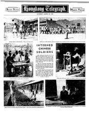
It was initially built in 1939 as a camp for interned Chinese soldiers. During the Japanese occupation it was used as a POW camp, then after the war it was used as temporary accommodation for groups of people passing through Hong Kong. Around the end of the 1940s it was combined with a piece of empty land to the west and became the Argyle Street army camp.
Timeline:
- 1939. The camp was built for interned Chinese soldiers who had surrendered in Hong Kong in 1938.
- June 1939: The soldiers had originally been interned in the nearby Ma Tau Chung Camp, mixed in with refugees from China. The arrangement wasn't working well and so in June 1939 a plan was announced to build a separate camp for the soldiers at Argyle Street. See NEW CAMP FOR MA TAU CHUNG INTERNEES, p.8, HKDP, 1939-06-13 (via eurasian_david).
- Dec 1939: The new camp is completed and the soldiers are moved here. See NEW CAMP FOR SOLDIER INTERNEES, p.7, HKSH, 1939-12-24.
- 1942-44. The Japanese used the camp as a Prisoner of War (POW) camp for officers. Its time as a POW camp is described in detail in Tony Banham's 'We shall suffer there'. He gives a brief description, map and photos on his website:
- In April 1942, the Argyle Street Camp was opened for officers, who were accompanied by 100 Other Ranks who primarily acted as cooks and batmen. (Note that in the background of the Argyle Street photo to the left, the Central British School - now KGV - can be seen).
- [...] In 1944, Argyle Street was closed too, with the officers moving to Shamshuipo (which was then split into camps ‘N’ and ‘S’). The situation in Hong Kong then remained virtually unchanged until the end of the war.
- c. 1945-49. After the war the camp was used as temporary accommodation to house groups of people who were being relocated.
- c.1950. The land and buildings became part of the new Argyle Street Camp for the British Armed Forces.
Later place(s) at this location
Photos that show this Place
1941
1943
1945
Comments
argyle street forces accommodation
in the 60s the streets surrounding the 'camp' - forfar road, lomond road (also bits of argyle and the whole of perth street going left from princess margaret rd) were two storey buildings with ample space, front and back gardens - and known as 'forces accommodation'. i once went to a birthday party on forfar which was temporary accommodation for parents of my friend who worked in air traffic control/teaching. this makes me think the army had some lease/rent to hk government before eventually they were knocked down. brilliant flats!
Re: Argyle St Camp
David, you may have to put the 'y' back in Argyle!
Back in the 80s after the British Forces had withdrawn and ceased to be a Vietnamese Refugee Camp , the Medical & Health Department of the Hong Kong Govt and later the Hospital Authority had control of the site.
Argyle Street Camp
Thank you all! I submitted the question and didn't mean for it to show up as Anonymous. I've been in touch with Tony Banham and he does have great information about the camp during the war years. It pops up in different books like Philip Snow's The Fall of Hong Kong and Emily Hahn's China to Me, but nothing longer than a sentence or two.
The Vietnamese left the camp in '92, so did the Medical & Health Dept. have control of the site before the Vietnames came in 79 or 81 (I can't remember when they started using Argyle for the refugees, but it was one of those years) or after they left in '92? When I moved back to HK in '94, I'm almost sure that the land had been developed into high-rise luxury flats. It was quite a prime piece of real estate, being so close to Kowloon Tong and on the outskirs of the congestion of Mongkok.
Re: Argyle St Camp
I think the M & H Dept had control of the site after the Refugees had vacated and that would have been in the early 90s.
Tin Kwong Recreation Ground
Didn't part of it become the recreation ground? I haven't got a copy of Wordie's Kowloon book but I thought it made a mention of this. I could be mistaken.
Another good book that contains a lot of info about the camp is Oliver Lindsay's "Battle for Hong Kong 1941- 1945". It merges the invasion story with the memoirs of John Harris who became a POW at the Argyle Street camp.
Re: Tin Kwong Recreation Ground
I think the Recreation Ground that you may be referring to would be Mission Road ( I think named after the Norwegian Mission) just across the road from the Argyle St Camp and opposite KGV on Tin Kwong Rd.
It was MOD (Ministry of Defence) property and used as a cricket field/pitch in later years.
Changing names
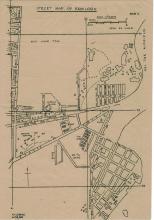
The 'Leven Road' mentioned in the 1950s document was later renamed to the current 'Lomond Road'.
Sheung Yan Road no longer exists at all, but ran between Lomond Road and Pentland Street, roughly through the middle of the present St Theresa's hospital site.
There are changes on the south side of Argyle Street too. Today Tin Kwong Road runs south from Argyle Street, then turns a corner to run east to Ma Tau Wai Road. Previously only the short east-west section was called Tin Kwong Road, and the north-south section was called Mission Road (see Moddsey's mention of the Mission above).
All these older names are visible on the 1947 map of Kowloon (Plate 4-7, Mapping Hong Kong).
Argyle St camp
My first home was on Prince Edward Road. The side road, I am pretty sure, was Lomond Road. We were nexr to St. Teresa's hospital. I lived in one of those two storeyed houses with front and back garden. I used to look out of the first floor window of the little back room and see a soldier on duty with his rifle. It scared me. When the house was demolished and the present building was finished, we moved back. I spent most of my life at that address, in the fifties and sixties; so I am a little curious about the barracks as well!
whoops!, not Recreation Ground...I meant Cricket field
I have hold of a copy of Wordie's Kowloon book and the associated map identifies the cricket pitch on the eastern side of Tin Kwong Road as (at least part of) the camp.
He also identifies a whitewashed storage hut as the only remaining original. So is the eastern side of the road the location of the camp? This was the place I meant when I mentioned the recreation ground earlier.
Notes about Argyle Street Camp
Richard Wong:
The Argyle camp was used as La Salle College from 1947-1957. In the late 1970s, it was used to house Vietnamese boat people awaiting resettlement in third countries.
Guy Shirra:
Argyle Street Camp in the 70s was home to 10 Intelligence and Security Company (Ten Coy), British Army Intelligence Corps. NOW KC Law Courts.
Argyle St Camp
How big was it exactly? I was under the impression that La Salle used a site on Perth St while the school was still being used as a (military hospital?). Does this mean the camp stretched from Lomond Road all the way to Perth St and straddled both sides of the road?
Argyle St.
I lived in the Kowloon City Police Flats in 1951-1954 and again in 1954 to Sep 1956. The 4 story building is the accommodation block for the living in local police stationed there. There was a courtyard behind with a gate onto Argyle St at the end of the office block. The flats were immediately behind from the direction of the photo and are out of sight because they were set back with lawns in front. There were twelve in two sets of 6 with a row of garages at one end.
The flats have been pulled down and new flats put in their place, but the police station survives. Along the pavement from the 4 story block,still stands the office block which only went up to a first floor with cells below.
As for the army camp by the Police Station, it was still occupied in the 1950s and in the space between the camp, Argyle St and the Station were market gardens growing carrots amongst other crops, - I used to "scrump" carrots by crawling through the crop! The wall you can see supported the hill which was taken away and is now a sports ground. I was arrested with a friend by Royal Military Police who came behind us while we destroyed the camp fence by throwing rocks down from the hill. My father had to come from Kowloon Central HQ to collect me so thre memory is clear. I will post some pictures to show the flats and some views of the 4 story block.
regards
Stephen
La Salle / Argyle St
Richard Wong wrote:
The Argyle camp was used as La Salle College from 1947-1957.
However, as Phil notes, the temporary site for La Salle was south of Perth Street, east of Princess Margaret Road. See http://gwulo.com/node/15185 (Also it was at that site between 1949-59 not 47-57 according to the school's website.)
The Argyle Street Camp did have a section south of Argyle Street (see "(18) Argyle Street Camp No. 2:" above), but I don't know if it ran as far south as the La Salle site. Can anyone confirm?
Regards, David
Argyle Street Camp
Argyle Street Camp can be viewed here
Argyle Street Camp
Henry Ching notes that the post-war camp covered a much larger area than the wartime POW camp:
I think some confusion has arisen from the use of the term “Argyle Street Camp”. The term used post-war by the Army referred to far more than the site of the POW camp during the war. In the Facebook photo referred to, the POW camp was only the area with the wooden huts at the right of the photo. As far as I can recall this camp was never used by La Salle College. The western boundary of the POW camp was somewhat east of where Tin Kwong Road enters Argyle Street, roughly in line with to-day’s Pentland Street.
I think I may have found the
I think I may have found the origin of the Argyle Street Camp:
“NEW CAMP FOR MA TAU CHUNG INTERNEES
-----------------------------------------------------------------------------------------------------------
Chinese Government’s Proposal
It is learned that the National Relief Commission will allocate a sum of $200,000 for a proposed new camp for the Ma Tau Chung internees. Should this scheme be approved by the Colony authorities, the site of the new camp would be on Argyle Street, near the Kowloon Hospital, where the necessary vacant land is understood to be available.
The present state of affairs where the internees are mixed up with a large number of refugees in their Ma Tau Chung camp, has long been deemed unsatisfactory, but for the lack of necessary funds and a suitable plot for the erection of a new camp, things were allowed to drift.
The conditions of the internees at Mau Tau Chung are engaging the attention of the Chinese Government authorities, and they now propose to allot $200,000 for the erection of a new camp, where the ex-soldiers may find better and more suitable quarters.
Plans Mapped Out
Plans for the new camp have been mapped out, and as soon as they are approved, work will be started.
Construction of the proposed camp will follow very much the same lines as other refugee camps in the new Territories, being paved in concrete cement and divided into a number of wooden houses, and rounded off by iron rails. The new camp, it is estimated, would house about 1,000 to 1,200 persons.”
Source: Hong Kong Daily Press, page 8, 13th June 1939
That does sound like the
That does sound like the origins of the camp - good find! It sounded as though work would soon begin on the new camp, so I had a look in the PWD Annual Report for 1939, and found this mention:
55. Camp for Chinese Interned Soldiers:—The site is at Argyle Street, Kowloon, and the work consisted of the erection of a hutment camp of timber construction with concrete floors, except the kitchen which has brick walls and a roof covering of asbestos sheets, together with water and fire services, drainage, channels, recreation ground and approach road. The camp is surrounded by a wire mesh fence with barbed wire entanglements and seven sentry watch towers are provided. There are eleven sleeping huts with accommodation in each for seventy two persons; one dining hut; one kitchen with store and office; one sanitary block containing latrines, ablution and wash house; one hospital hut with an office for the medical officer, three wards for eight, four and two persons respectively, dispensary, store and latrines; two huts for the outer and inner police guards with an office, quarters, mess room, kitchen, store and lavatories; a gate keeper’s hut; lock up; incinerator and refuse bunker. The contract was let to Messrs. Tung Shan & Company on 17th October and the work was satisfactorily completed on 15th December.
1975 map
This 1975 map shows the camps occupied a whole block at the north west corner of the Argyle st - Lomond rd junction