17 Peak Road
Moddsey wrote:
[In the 1920s], the manager (taipan?) of the Chartered Bank lived in the Charter House, the Peak. Address given at the time was 17 Peak Road.
17 Peak Rd, is now occupied by Dynasty Court Tower 1 & 2 at 17-23 Old Peak Rd.
Charter House can also be found (with a few letters missing) on Public Records Office Map MM-0003 PLAN OF THE CITY OF VICTORIA, HONG KONG, 1889, Large correction 1900. (not viewable online).
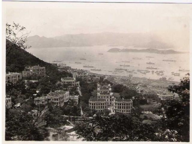
It was still around in 1931 as shown on one of the Norman E Fieds photos of Old Peak Road and the harbour.


Photos that show this Place
Comments
How do we date some of these old pictures?
the 2 houses of Queens Gardens ( to the left and below the 5 buildings) were demolished in 1935,
and a tender for the demolition of the 5 main buildings was accepted in July 1935, so definately pre-war,
Victoria Lodge (the residence of the French Consulate General) was built in 1895, and half of it was demolished in about 1959 to fit in Friston then Balmacara (on the site of Charter house). I always thought it was funny to build a house with no windows in the end wall ;-), now I know.
When was Charter house demolished?? certainly pre 1945, I'll keep looking for a better date.
18 Old Peak Road was there until 1965.
22 Old Peak Road wasn't there in 1945 either.
The little house on May Road in the far left of the picture was built in about 1905 and was replaced by a 5 story building pre-war.
May Road was built in 1907.
Marlowe, thanks for the photo and the extra information.
Putting a date on these old photos is an interesting puzzle. It's worth a section of the website on it's own, as I'm sure different people have come up with different ways of doing this. It's a good habit to share how we know the dates we know, to give clues to others who are also looking.
One extra bit of information from the map 3-5a (1030-45) in 'Mapping Hong Kong'. The group of five buildings are shown in the colour for government property (residences for government staff?). The two larger buildings face Old Peak Road. Conduit Road runs between them, makes a slight Z-curve to the right (you can see it in the 1931 photo), then runs along the front of the three smaller buildings behind.
I was about to make a place for them, but reading the notes above I'm not sure exactly where they were. Please can you clarify?
Today's Queen's Garden development is given the address '9 Old Peak Road', and roughly occupies the land of the group of five buildings on Old Peak and Hornsey Roads shown in the 1931 photo.
Yes, they are all on the same site, but bear in mind that the "Hornsey" road moved some time after 1937.
The old Queens Gardens (c.1880) were sold by the Govt in 1880, and repurchased in 1924. One building is "above" May Road, and one is "below" May road, where Hornsey Road is now.
The road is shown on old maps as "Queens Gardens", and is a continuation of May road, with a slight dogleg, as you said.
The newer Queens Gardens (c.1948) seems to be built on top of that road.
Hornsey Road is post war and is about 10-20m closer to the harbour.
They shifted a lot of soil post war ;-)
Queen's Gardens refers to the area where I suppose the 5 buildings were built. However in 1907, the road from May Road to Conduit Road was also called Queen's Gardens and perhaps became Hornsey Road after 1945. There is no record of Hornsey Rd prior to 1941.
The Government quarters that I mentioned previously, in fact the 4 buildings in Queen's Gardens were demolished in 1937.
Yes, I lived at Douglas Apartments (22 Old Peak Road) from 1961-65, then moved to Luginsland (18 old Peak) in 1965-1975. I went to school at Glenealy, so I walked past Queen's Gardens every School day until I went to Island School.
My interest is Old Peak Road, May Road and Tregunter path.
I'm trying to date all of the buildings, using what I can find on the net. Not being in Hong Kong is a great disadvantage. Every time i think I have a definitive date on something, I find another reference to contradict it ;-(
Does anyone know the name of the 5 story apartment building (built pre-war) on May road, above the LRC, that faces onto Old Peak road? it was there until about 1982. I've been racking my brain, and I can't find any reference on the net.
My older brother lived on Bowen Road (before I came along) so his interest is Bowen Road and the Filterbeds below the LRC.
Have a look at my Flickr page
http://www.flickr.com/photos/alunc/sets/72157613645207364/
and my pathetic blog site
http://oldpeakroad.wordpress.com/
Thanks for the introduction. It's not an area I know much about, but I'm interested to hear more about it.
Dating buildings, showing photos of them, and navigating through history to older buildings at a given location are some of the features here. You're very welcome to to use those features to ask others for more information. Let me know if you need any help about getting them to work.
You're right about the dates though. I find newspaper searches are a good way to get a firm date, especially when the opening of a new building is reported. Otherwise we kind of circle around, picking up clues that help narrow down the right date.
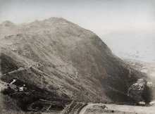
This phot must shed some light on the area: taken by hedda morrison in 1946, it shows the desolation in the hills above the botanical gardens. Anyone know where it's taken from? Magazine Gap Road? or which are the surviving buildings?
http://via.lib.harvard.edu:80/via/deliver/deepLinkItem?recordId=olvwork348279&componentId=FHCL:1081059
The picture is taken from further up Old Peak road, I can map out 3 places where it could be.
You can see the houses on the right hand side of Old Peak Road, below the LRC, but I remember those from the 60's.
there's the club house of the LRC, the house on the site of clovelly court with the prewar apartments across the road (still can't remember the name of them), Victoria Lodge and #20 Old Peak Road.
I'd like more detail of Queen's Gardens and below, there should be a road running through there, and as I've said before, they shifted a heck of a lot of soil before they put up the 2nd generation of Queen' Gardens.
and there's no sign of Friston Cottage, Tregunter, 22 old peak road and Charter house, which are hidden in the trees.
I don't believe any of the buildings on Old Peak Road are still there now, however the Tennis Courts at the LRC haven't changed position - as far as I know.
Hi there,
From the point of view the photographer was shooting from somewhere closer to the peak. In the photo, the Governer House was nearly in the middle of the line of sight. If you zoom in you should be able to see where Robinson Road meets Garden Road and Magazine Gap Road.
Thus I think it could be May Road, or Conduit Road. A section of Barker Road was in the right point of view, but that is unlikely as it would be higher up. The photo didn't show it was too far away from Robinson Road.......
My 2 cents.
T
I also lived at Luginsland from 1965 until 1971. Used to go and walk around the building site imagining how the apartment would look once my parents and my brother and I would move in with our furniture. Was the building looking onto the LRC called Tregunter Mansions? It was an old five storey building which was pulled down and then a new one built on the same site.
Futher research has shown that the 5 story building, which looked like it was on Old Peak Road, but was actually accessed up steps from May Road, was called Abermor court. It was built in 1931.Tregunter 3 (66 Stories was built on the site)
http://www.flickr.com/photos/alunc/3282732823/in/set-72157613645207364/
It was on the old peak road side of the Nullah, and Tregunter was further up (10-14 stories), and built over the top of the Nullah. They shifted a lot of soil in 1954 when they built Tregunter.
I was at Luginsland at the same time, so I guess we know each other, what was your brother's name?
Alun
Yes, I had friends that lived in both Friston and Balmacara.
Friston was built on half of Victoria Lodge (the residence of the French Consul General), and Balmacara was built on the site of Charter House.
http://www.flickr.com/photos/alunc/3271931982/in/set-72157613645207364/
I could never understand why there were no windows on the end of Victoria Lodge, just a blank wall, but I know it was only half of the original building ;-).
I'm sure we annoyed the French, by kicking footballs against the side of their house.
Alun
Picture of Friston and Balmacara - early 70s
http://www.flickr.com/photos/alunc/4227926962/in/set-72157613645207364/

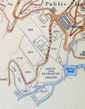
The "two houses" below Queen's Gardens. Never heard of them ? Nor had I. They were built not long after the Albany along with the Blue Bungalow (I do love that name.) They are now Kam Yuen Gardens. I've created them as "places" so if you have them in your photos and postcards you can id them. Kurahjeen was the one right next to Old Peak Rd.
Clovelly Court - that would be here https://gwulo.com/node/4943
Comments
Old Peak Road 1919
Here's another picture from 1919 - the photographer was there for the Peace celebrations.