That's a great view of an area we don't have many photos of.
The bottom-left corner shows the gas works, the dark line curving up from the bottom centre of the photo is the Hill Road Nullah, and just above the centre of the photo is the main building of HKU. So this is a view over Shek Tong Tsui and HKU.
This is such a nice aerial photo of the upper section of West Point. The main focus seems to be Saint Anthony Church in the center-left section of the photo. This is a Roman Catholic church built in 1953 and is still there today. The large playground to the left of the church is part of Saint Louis School which I attended in the sixties and early seventies. The old and the new buildings next to the playground are part of the school buildings. The little alley behind the school buildings is Yuk Ming street. This street does not exist anymore. In the Nineties, all the buildings around Yuk Ming street were torn down and a new high rise called Yuk Ming Court was built. The street below Saint Louis school is Queen’s road west. The cylindrical structure next to Queen’s road west is the storage tank of HK (Coal) Gas Works. It was demolished in the early sixties and replaced with high-rise apartments. The winding road in the center section of the photo with an open ditch next to it is Hill road. The open ditch was part of the drainage system to channel rainwater from the hill above to Victoria harbor. This open ditch was paved over in the early sixties. The streets in front of the roll houses between Saint Anthony church and Hill road are Po Tuck Street and Clarence Terrace.
Of course, the building above Saint Anthony church is the Main Hall of Hong Kong University (HKU). It was built in 1912?? The buildings on the far-right side of the photo were the engineering lab. building of HKU. They were all torn down and replaced with high rises now. The buildings in the upper right-hand side of the photo are HKU professor quarters. Blocked by some of the buildings in the photo is Pokfulam Road. You can see part of the road next to the church and another part next to the HKU engineering lab. building. On the upper left-hand side of the photo, one can vaguely see the school building of King’s College, a very prestigious HK government-run high school. Surprisingly, the school and the school buildings are still there today. Also, if you pay a little attention, in the same upper left-hand side of the photo, the dark triangular shape structure is the Saint Stephen’s Church school chapel. It is an Anglican chapel built back in 1900? It was torn down in 1965 as part of the expansion effort of Saint Stephen’s church school. Near the top of the upper left side of the photo, one can vaguely see the campus of Pui Ying middle school. Again, the school is no longer there and is replaced by apartment high rises
Comments
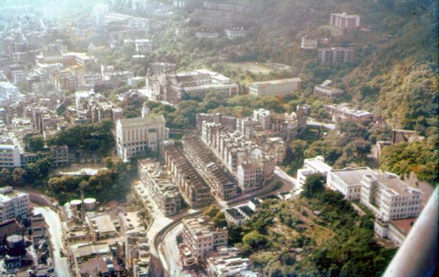
That's a great view of an
That's a great view of an area we don't have many photos of.
The bottom-left corner shows the gas works, the dark line curving up from the bottom centre of the photo is the Hill Road Nullah, and just above the centre of the photo is the main building of HKU. So this is a view over Shek Tong Tsui and HKU.
Saint Anthony Church
This is such a nice aerial photo of the upper section of West Point. The main focus seems to be Saint Anthony Church in the center-left section of the photo. This is a Roman Catholic church built in 1953 and is still there today. The large playground to the left of the church is part of Saint Louis School which I attended in the sixties and early seventies. The old and the new buildings next to the playground are part of the school buildings. The little alley behind the school buildings is Yuk Ming street. This street does not exist anymore. In the Nineties, all the buildings around Yuk Ming street were torn down and a new high rise called Yuk Ming Court was built. The street below Saint Louis school is Queen’s road west. The cylindrical structure next to Queen’s road west is the storage tank of HK (Coal) Gas Works. It was demolished in the early sixties and replaced with high-rise apartments. The winding road in the center section of the photo with an open ditch next to it is Hill road. The open ditch was part of the drainage system to channel rainwater from the hill above to Victoria harbor. This open ditch was paved over in the early sixties. The streets in front of the roll houses between Saint Anthony church and Hill road are Po Tuck Street and Clarence Terrace.
Of course, the building above Saint Anthony church is the Main Hall of Hong Kong University (HKU). It was built in 1912?? The buildings on the far-right side of the photo were the engineering lab. building of HKU. They were all torn down and replaced with high rises now. The buildings in the upper right-hand side of the photo are HKU professor quarters. Blocked by some of the buildings in the photo is Pokfulam Road. You can see part of the road next to the church and another part next to the HKU engineering lab. building. On the upper left-hand side of the photo, one can vaguely see the school building of King’s College, a very prestigious HK government-run high school. Surprisingly, the school and the school buildings are still there today. Also, if you pay a little attention, in the same upper left-hand side of the photo, the dark triangular shape structure is the Saint Stephen’s Church school chapel. It is an Anglican chapel built back in 1900? It was torn down in 1965 as part of the expansion effort of Saint Stephen’s church school. Near the top of the upper left side of the photo, one can vaguely see the campus of Pui Ying middle school. Again, the school is no longer there and is replaced by apartment high rises