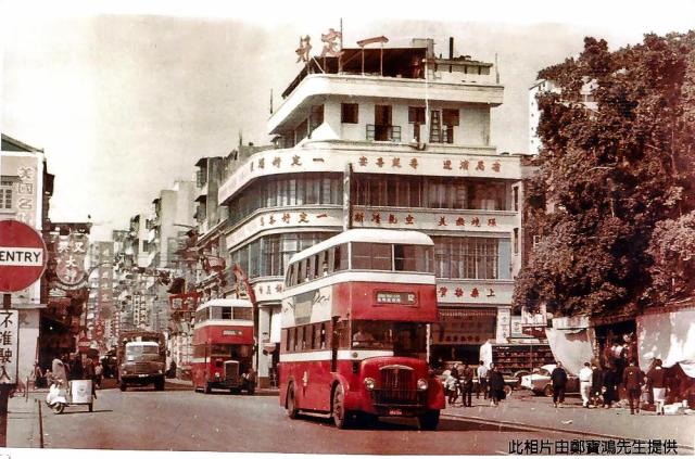
Bus #12 followed by likely #4 travelling southbound on Shanghai Street, just passed (Edit April 21 as per readers' comments) Public Square Street. Note the one-way sign and the shadow cast by the bus. The tea restaurant was the sight from my daily bus ride in 1950-51 to school.
Location map: https://gwulo.com/taxonomy/term/478/places-map#17/22.30896/114.17064/Ma…
Photo source: uwants.com - post #1175 by user 4rex - http://www.uwants.com/viewthread.php?tid=14833421&page=79#pid207765320
Date picture taken
1950s
Shows place(s)
Comments
Location
Hi Peter,
I'm not sure this photo shows the Market Street / Shanghai Street crossroads, as the map shows the road did a zig-zag there, but this photo shows it running straight. Could it show somewhere else along the route of Bus No 12?
Regards, David
Thanks David for the feedback
Thanks David for the feedback. I have been wondering about the zig-sag. One explanation, just assumption at this time, is that the map maker enlarged the block to squeeze in the label for the community centre building and for the market block. Elsewhere between Jordan Road and Lai Chi Kok Road, I don't remember any block that had such big trees. It would be nice to locate an air photo for this period in time. At that time, Bus #12 used Shanghai Street between Jordan Harbour and Lai Chi Kok. Bus #4 used Cheung Sha Wan Road so the second bus in the photo might not be #4 but was an older version than the first. I remember those days when drivers got off the bus with a simple tool to crank-restart the engine. Regards, Peter
Edit September 11, 2017 - Thanks David for introducing the 1945 map of Hong Kong and Kowloon. It agrees with the 1956 Map in that both show the shanghai Street block between Public Square and Market was indeed at one time wider, hence the zig-zag car/bus traffic. Regards, Peter
Public Square St
im pretty certain the white building at the back sits on the corner of Public Square Street. I remember Thomas found this one when identifying one of my film locations. The public square in front of the Tin Hau Temple is on the right
Re: Public Square Street
Yes, corner of Shanghai and Public Square Streets as viewed here
Public Square Street
Thanks to all for the overwhelming support. I mistook the block on the right side of this photo to be the market located on the south side of Market Street. The main page has been corrected to reflect your clarification.
The second and third photos in moddsey's link bring back memories of my view from the bus. In it, it says the temple at one time was on the waterfront. So the water in the photo "Sham Shui Po, looking to the east" was indeed sea water - https://gwulo.com/atom/27967
Regards, Peter
another angle
Another angle (camera closer to Market St junction) can be seen here