Greetings. This is one, may I suggest, nostalgic and romantic landscape of the old Kowloon. The person who posted this photo on the internet did an amazing job in determining the vantage point to scan the distant hills. The inundated area on the right must be the current Mong Kok district. Under sea water, or after a heavy rain storm? The farms and tranquility, oh, how this land has changed!
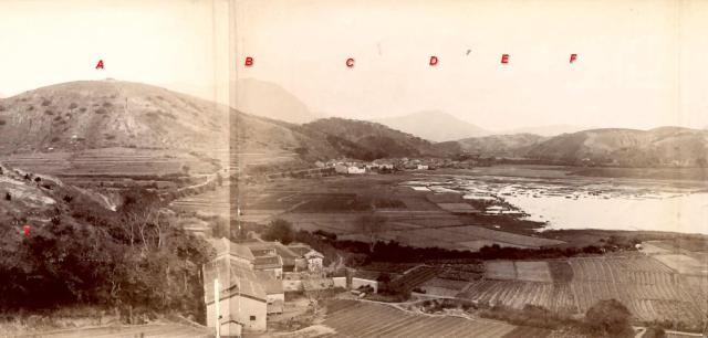
Here are the author's notes translated from Chinese corresponding to the letters on the photo:
1. This photo was taken at about the present 207-209 Tai Nam Street near Lai Chi Kok Road, Sham Shui Po, where there was once a hill 77 metres above sea level.
2. Using the 1904 map, a point of reference, marked "X", was established at the small hill 88 metres high corresponding to the current 120-124 Apliu Street address, a line of sight was drawn for each of the followings:
Point A: Woh Chai Hill 窩仔山, elevation 264 metres. (Its foothill on the camera's side would be the present Tai Po Road / Nathan Road)
Point B: 飛鵝山 Fei Ngo Shan / Kowloon Peak 602 metres.
Pont C: a hill at elevation 216 m about the site of the present Osmanthus Road, about a few hundred metres further east from Woh Chai Hill.
Point D: 上托 (no English name has been identified, this hill would be east of Fei Ngo Shan going on Clear Water Bay Road.
The layout of the farm houses was such that they face south - a preference, a necessity that they over look the farms, and back onto tall vegetations for protection from northern wind. There was likely a duck farm at one time hence the spot later was named Apliu Street.
Comments and corrections including the date of the photo would be much appreciated.
Photo source: uwants.com - post #1536 by x215137 - http://www.uwants.com/viewthread.php?tid=14833421&page=103#pid210654488
Comments
D
I think D is the hill that became the Anderson Rd quarry.
Anderson Road quarry
Thank you plilk for the connection with Anderson Road quarry.
The vantage point for the camera was about 3 blocks northwest of my home but only from the roof top it was possible to for me to see these hills. I was awed by this farming scenery and I am sure the photographer would also have been awed by what he/she sees today. Regards, Peter
hill on left
Peter - those buildings in the foreground would correspond to whereabouts today...maybe the Garden Bakery building? I guess the small hill in the foreground on the left would be Garden Hill where Tai Po Road runs past now?
Sham Shui Po, looking to the east
Hi philk, thanks for the interest.
According to the notes of the photo's author, the camera that took this photo was at the present 207-209 Tai Nam Street so the houses in the foreground would be at or near this location. If correct, these houses would be about 200 metres south of Tai Po Road (yet to be built at the foothill) and about 400 metres south of the peak of Woh Chai Hill. To see Garden Hill and Garden Bakery (near Tai Po and Yen Chow) from this address, we would need to rotate our line of sight 90 degrees to the left (north) so that would be outside this photo.
This is how I understand the author's work. Using an old map and current Google photos, he/she located a spot that best matches the line of sight to the key topograhic features in the photo, and marked the spot "X" at the current 120-124 Apliu Street. I am not clear about the connection between this "X" and the Tai Nam Street address, except that it was likely a process combining analysis and judgement. Regards, Peter
Sham Shui Po
Oh I see, many thanks for clarification.
Cheers
Phil
Sham Shui Po
You are welcome, Phil. Regards, Peter