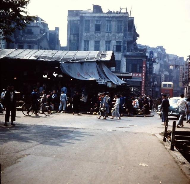
If one looks at the 1956 Kowloon Map, the road that runs through from top to bottom that has a kink is Shanghai Street. Today, the road has been straightened.and the market has disappeared. On the right are steps leading down to somewhere ? Does anyone know?
Source: This image came from Flickr, see https://flickr.com/photo.gne?id=28740422193
Date picture taken
1957
Gallery
Shows place(s)
Comments
Market Street and Shanghai Street
Greeting. That could be #12 Bus on the congested and narrow Shanghai Street. Just a guess - steps leading down to the public washroom? I walked around it from left to right at this spot, but today have no memory of its purpose.
These hints might work: opening and pavement around it were purposedly built for easy and permanent accessibility to lower level, side railing was in bad condition but the landing had no barrier meaning people have unobstructing access to below, barely visible are the stairs and a person coming up (or going down), it looks like it was to one far side of Shanghai Street, this was a market area so public washroom would be my guess given Western Market in HK had one though above ground. Regards, Peter
Thanks Peter
I, too was thinking of an underground water closet.Will see if I can I find further information. Thanks.
Junction of Market Street and Shanghai Street
Greetings. David's "New Map: 1956 Kowloon" I believe confirms that the camera-man was standing on Shanghai Street, about 30 feet or 10 metres south of Market Street, and looking north along Shanghai Street. The camera was able to capture the northwest corner of the market block and entrance to below. South of Public Square Street, notice the buses to and from Jordan Ferry terminal used two different routes. This explains why the photos I have seen show one-way traffic on Shanghai Street. Regards, Peter
re: Junction of Market Street and Shanghai Street
Hi Peter,
I had the opposite orientation in mind, see if this works: The photographer is standing 10m north of Market Street on Shanghai Street looking south.
Then the low building on the left with the canvas awnings is the market.
In the distance, beyond the bus, Shanghai Street bends to the right / west, as shown on the map.
That would put the steps next to the building shown just above the marker on the map. It has a Chinese description on the map, which unfortunately I can't read :(
Regards, David
Chinese words
Hi David,
Here is your orientation with the Chinese words, as written on the map. Not sure if it helps. According to your view, the steps down below ground level are part of the Yau Ma Ti Welfare Association. Not sure about its history, or if this is a government or private body.
breskvar
Junction of Market Street and Shanghai Street
Greetings, and thanks brskvar and David.
My original thinking was that those street vendors were on Market Street (missed the curb) and not within the "Market" block, and the steps could not have been a part of a residential or comercial building. David your explanation makes sense including Shanghai Street's bending to the right.
The map may not be true to scale and street/block widths are distorted. In the photo, the depth of the market's appears quite small so the map maker might have enlarged the block to squeeze in the two Chinese characters. The steps in the photo aligns well along the west side of Shanghai Street. Thus, it would be possible for the camera to capture the steps with David's coordinations. Many thanks for your good work and better thinking. Regards, Peter
re: Junction of Market Street and Shanghai Street
Thanks Breskvar, good to know what the buildings are.
Those steps are still a mystery. I looked through the results of a search for latrine in HKGRO. I didn't find a match for this location, but that search isn't 100% accurate so some sort of public toilet still seems a likely explanation. Hopefully a photo from another angle will surface at some point, and we'll get a better view.
Junction of Market Street and Shanghai Street
Greetings, and continuing interest ..... Current Google street view shows 4 traffic lanes (a coincidence?) on Shanghai Street north of Market Street so it was wide enough to accommodate these steps with opening within the road pavement and not connecting (at least above ground) to a building. Like the "Market" block, the "YMT Association" block on the map was enlarged to squeeze in its label. I was able to walk 4 metres along one side and clockwise around the tip (both shown in photo) then similar length along the other side. If not public washrooms, this could be part of a drainage network. Regards, Peter