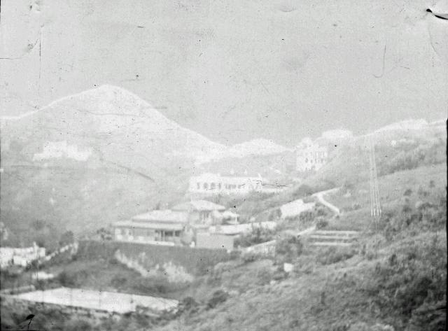
This was in an envelope of negatives labled "Mr. Johnson". They would have been kept by Mary Wright, wife of J.F. Wright, and taken when they lived in Hong Kong. I am curious about the date, and the tower to the right of the buildings. Also, I would be grateful if anyone could tag the buildings. That is beyond my level of expertese! I believe that the building above what is either a foundation or a tennis court is Creggan [RBL-8 is near Strawberry Hill, just off Plantation Road], built by Thomas Jackson - probably in 1877. SEE: http://www.thesilverbowl.com/misc/FarEast/Creggan-Hongkong.html .
Date picture taken
1890s
Gallery
Shows place(s)
Comments
The Mount
The tallest building in the negative, the one to the right of centre, seems to have three or four floors and a small dome. The only building that tall with domes or peaks on the roof in the area of Mount Gough/Jardines Corner/Mount Kellet that I'm aware of was "The Mount". It lasted from 1887 to 1945 according to www.gwulo.com/node/5024
The Mount is also seen in www.gwulo.com/atom/12907 with two bungalows beneath it which, if I'm reading the caption correctly, were said to be Dunford and The Chalet, and look something like the two buildings beneath The Mount in the photo above.
Fairly confident about The Mount, but less so about the other two.
re: Gilford Negs 009 Invert.jpg
Hi Sharon,
I'm not sure if this is Creggan or not. Please could you post the photo too if possible, as it is easier to make out the buildings in that.
I think the tower is actually a set of power / telephone lines. If you look at the base of the vertical lines you can see white shapes that are the ceramic insulators, and below them is the wooden pole.
Are there any clues about when the negatives were taken?
Regards, David
Stokes Bungalow and Dunnottar
I've had a rethink. Earlier I'd concluded that the two bungalows in Sharon's old negative were Dunford and The Chalet. Now I'm thinking the one nearest the camera is Stokes Bungalow (www.gwulo.com/node/4921) and the one behind and above it is Dunnottar. Here's why.
This old pic, taken from a slightly different angle to Sharons, appears on the "Visualising China" website.
http://visualisingchina.net/#http%253A%252F%252Fwww.visualisingchina.ne…
It clearly shows the east side of the same building with its roofed verandah over a stone wall with a large flat area beneath, which could be a tennis court judging by its size, oblong shape and the tall poles around its periphery which may have carried netting. Here's another similar view.
Both photos give a better view of the white building below the nearest bungalow. From its general appearance and location, low down in the valley to the east of Mt. Kellett Ridge, I'm confident its The Falls, 1st Generation (www.gwulo.com/node/4927). If so, its position relative to the two higher bungalows in Sharon's negative helps to place them more accurately.
The Falls is in the bottom right of Annelisec's photo. Between it and The Peak Church (roughly in the middle of the photo) is a dark roofed building which Annelisec identifies as Stokes Bungalow.
Also posted by Annelisec, this sketch illustrated a magazine article about an Open Air Ball at Stokes Bungalow on 20-7-1888. According to the accompanying text (full version at www.gwulo.com/atom/12928), party-goers waltzed the night away on the tennis court. The drawing of dancing on a tennis court below a wall topped with a roofed verandah looks very like the photos above.
Based on it general position and the tennis court, I'm prepared to say that the building nearest the camera in Sharon's negative is Stokes Bungalow.
From this extract from the 1909 Peak Map (www.gwulo.com/atom/14774) we can conclude that Sharon's negative must have been taken somewhere to the east of Stewart Terrace, looking over Stokes Bungalow with Mount Kellett in the background. According to the map, the nearest building in that direction was Dunnottar. It's also seen in Annelisec's old photo above, being the white bungalow immediately to the left of Stokes Bungalow. Based on its position and distance from Stokes Bungalow, I reckon Dunnottar is the building behind Stokes Bungalow in Sharon's negative.
I visited this area of The Peak yesterday to see if anything of either buildings remained. The Stokes Bungalow site is now occupied by a newish developement named "Gough Hill Residences". After a fruitless thrash around in the jungle, I'd concluded that nothing of relevance remained when I noticed this at the entrance on Gough Hill Path.
Stokes Bungalow was numbered 261-263 The Peak from the 1920's through to sometime in the late 50's or early '60's. Logically the sign should date from sometime in that era.
No luck regarding Dunnottar. Its site on Peel Rise is vacant awaiting redevelopement.
Good detective work on that
Good detective work on that one, and good to have the location and buildings identified.
Regards, David
This is brilliant detective
This is brilliant detective work. Now, I am curious about when telephone towers or electrical towers might have been installed. Then we can start to narrow down the date. Any thoughts about how to find that out?
Sharon's Photo
Here's the photo of Sharon's negative at the head of this string.
Not surprisingly, it's much clearer than the negative. The two buildings in the foreground have already been identified as Stokes Bungalow (nearest camera) and Donnottar (just above Stokes Bungalow). Now to try identifying the others and date the photo.
Based on the alignment of the buildings in the background and comparison with old maps, I think they are, from left to right, as follows;
1. Kenlis (www.gwulo.com/node/17737). The vague light blur on the extreme left of the photo below the Mount Kellett peak.
2. Des Voeux Villas (www.gwulo.com/node/18832). The two adjacent buildings in the centre of the photo where the slope down from the peak of Mount Kellett meets the horizontal ridgeline.
3. Government Pavilions. The small white building on the ridgeline to the right of 2.
4. Peak School (now Peak Fire Station, www.gwulo.com/node/5230) or Government Villas (www.gwulo.com/node/8713). The building on the ridgeline at the extreme right of the photo. As only part of it is shown, I'm not sure which one it is, but it's correct identification is vital to accurately dating the photo.
5. Ebordale. The two or three storey building between Dunnottar and 3.
I don't know when Government Villas was built, but it predates 1909 as it appears on the map of that year in the post of 10th January above. The next photo shows it sat ontop of a high wall above Gough Hill Road.
Government Villas is near the left edge of the photo, about half way down, a one storey structure with a high wall and road below it, not to be confused with the more prominent Dunnottar - the bright white bungalow below it. Between the two, just below the road is green hillside and is where Peak School would be built in 1915. Here's what it looked like after Peak School was built.
Peak School is the semi-hexagonal building in the bottom right corner with Government Villas above it on the other side of the road. Note that whereas Government Villas sits ontop of its high wall, Peak School has only a low wall and a natural slope below it.
Now look at Sharon's photo again. Is the building on the extreme right sitting ontop of a high or a low wall? A low one I think, but I'm not sure. Look again. I think there's something unusual about the angle of the corner of the building facing us. Could it be that it's not a square corner, but the corner of a hexagon?
If there's only a low wall and the corner's at a hexagonal angle, then the building is Peak School and the photo was taken after it was built in 1915. If there's a high wall and a square angle, then the building is Government Villas and the photo was taken before Peak School was built in 1915. I'm far from sure, but tend to think we're looking at Peak School after 1915.
Here's a similar photo to Sharon's, dated 1935.
The obvious difference between the ridgelines in Sharon's and this photo is the presence of the huge War Memorial Hospital. It was built in 1932 (www.gwulo.com/war-memorial-hospital). Given its size, surely it would have appeared in Sharon's photo had it existed when her photo was taken. As it's not seen, Sharon's photo can be dated to before 1932.
To summarize, I think Sharon's photo was taken sometime between 1915 and 1932, but that's based on the rather tenuous conclusion that Peak School is in the photo. If the building in question was in fact Government Villas, then Sharon's photo pre-dates 1915.
Wrights in Hong Kong
Hi Sharon,
Up at the top you wrote:
They would have been kept by Mary Wright, wife of J.F. Wright, and taken when they lived in Hong Kong.
Please do you have any more information about which years the Wrights lived in Hong Kong, and/or a full name for J.F.? That'll help narrow down the range that gw has identified.
Regards, David
I think the 3 story building
I think the 3 story building is Hillside. . which, according to the 1909 map, makes Creggan behind it a bit on the right.
James Francis WRIGHT
MAry WRIGHT (1872-1946) was born Mary MENARY, a niece of Sir Thomas JACKSON (1841-1915). Her husband James Francis WRIGHT (1874-1954) worked briefly with HSBC. They settled permenantly back in Ireland - I will have to check the dates when they bought Gilford Castle. She married in Hong Kong in 1902. She was in Hong Kong for sure in 1906: 1906 letter from Mary Griffin to Sarah Whiteside: "I am in a little anxiety about Mollie and her care just now as there has been a terrible typhoon in Hong Kong and loss of life and I am sure she has been well frightened if not hurt". The photo is most likely pre-1915.
Creggan
That would be my guess.
Creggan
Thank you. This is marvellous work!
JF Wright
I've made a page for him at: http://gwulo.com/node/31560
He appears in several years Jurors Lists, from 1907-10, and 1913-16.
James Francis Wright
For more information see: http://gwulo.com/comment/35460#comment-35460
Stewart Terrace, 90 The Peak
Interesting. The two Peak addresses given for James Francis WRIGHT in the Juror Lists linked above, i.e. Stewart Terrace and 90 The Peak, refer to the same building according to the 1909 Peak map extract in the post of 10-1-2016 above. It's also roughly the location from where Sharon's photo at the head of this string was taken from as mentioned in the 10-1-2016 post above.
I've had a rethink
Hi Sharon,
Wow, 7 years since I last had a good look at your photo! I've recently been looking at the Mount Kellett area again and have changed my mind on the date of your photo and the identification of some of the buildings in it.
I still believe that Stokes Bungalow, Dunnottar, Kenlis, Des Voeux Villas and Ebordale were correctly identified in my post of 4th Sept 2016. However, I've changed my mind regarding the buildings numbered 3 & 4 in that post.
3. The small white bungalow on the ridgeline. This is Myrtle Bank. It was built in the late 1800's and demolished to make way for the War Memorial Nursing Home in 1929 or 1930.
4. The bungalow seen in part on the ridgeline at the right edge of the photo. This is Government Pavilions. At least four buildings have occupied this site over the years, but the one seen here is the brick bungalow completed in 1911 and probably demolished in about 1950.
As Myrtle Bank and Peak Pavilions are both in the photo, it must have been taken sometime between 1911 and 1930.
Unfortunately, the presence of the overhead wires in the photo don't help to date it. The 1894 PWD Report contains a section headed, "Maintenance of Telegraphs and Telephones" and informs us that;
"...wooden poles in the lines...from No.6 Police Station to Pokfulam...have been replaced by iron ones", and "...Central Police Station is now in direct telephonic communication with...No.6 Police Station (and) Peak Signal Station".
As No.6 Police Station and Peak Signal Station were both on the Peak, pole mounted telephone wires had obviously arrived on the Peak by 1894. The fact that wooden poles were being replaced by iron ones, suggests they had been there for some time. The PWD Reports of subsequent years mention the expansion of the telephone system to other Government buildings on the Peak. I don't have any information of the installation of telephones in private buildings, but suspect that it would have occurred over approximately the same time period.
So, although the year of erection of the wires in your photo can't be established, it's fair to say that pole mounted telephone wires had reached the Peak and proliferated long before 1911 - the earliest your pic could have been taken.
Having concluded that telephones were on the Peak well before the start of the 1900's, I was surprised to read this;
"Electric current was not available in the Hill District until 1912 when the HK Electric Co extended their service of cables to that district". (Para.55, 1914 PWD Report).
"Hill District" was a name often used to describe Victoria Peak in the early days. I'd always assumed that telephones ran on "electric current", but apparently not. I don't know anything about telephones, but after some head scratching I recall seeing characters in old movies vigorously cranking small handles on telephone sets before making calls. I wonder if that cranking action generated electricity to power the call without the need for mains electricity?