You've done a nice job of lining up HK island in the background to get a match. Looking at the map, is the building on the hill in the middle the 'Caritas Ming Fai Camp' ?
In the past Don Ady has written how in the 1930s Cheung Chau was a place missionaries would go to rest after working in China. Looking at the map today it seems the church have kept the land since, as the list of building names show several for Caritas and a couple from the Salesians. Then there's a Bible Seminary, and one for the Salvation Army.
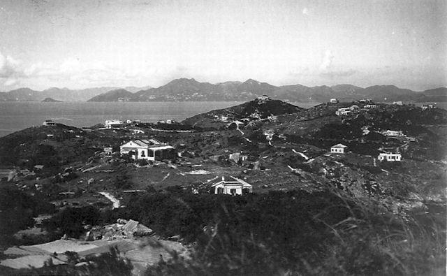
To examine this photo, the camera's focal view was directed to Pokfulam of Hong Kong which is a north-east direction. My best guess for the camera's location is being at the site of House #29 ( #30 was a military facility). By reason, the view would have put the House #27 & #28 on to the lower foreground.
So the far right of the photo was showing to the north-east-east, which has the entire Fa Peng and Nam Tam Wan regions with Lamma Island in front of the larger Hong Kong Island in the distant background.
On the photo's left, this nearby house was actually in the north-north-west w.r.t. the photographer, so the nearby house would be the Original House #27. It might be there already in the 1910s.
From other sources a Baptist Mission was established by the Tung Wan in 1850, at the time the Ching dynasty still holding the sovereignty on the region except the Hong Kong Island, the Victoria Harbour and the Kowloon Peninsula. It was sometimes later a new lease of the New Territory was added forming the final shape of the British Colony of Hong Kong
One must realize that the Ching Dynasty had a clause to protect the safety of western missionaries and their properties in China in the Treaty of Nanking and again the Treaty of Tienjin (? spelling-not sure) prior the 1900s and there were already houses for the missionaries on the island. These European Houses were not always having residents on a longtime basis. Since many missionaries worked mostly in the mission field like China mainland or Southeast Asia...etc They came to Cheung Chau during vacations or in transit via Hong Kong before set sail for a long journey home. So very often these European Houses were vacant without much protection.
The Westerners Only bylaw on the island was imposed later but it seemed to be just an assurance of safety during the 1910s and 20s, a high time of anti-westerner movement in some big cities in China. However the Bylaw, merely giving a reserved area for european residents, never meant to be a racist measure. There was never barbed wires, gated boundary, or security patrol to stop anyone entering this side on the island. Indeed we saw mostly missionary folks and families as the residents. They lives quite a low profile living and were well respected by the average islanders all times.
The Bylaw came with good intention and was withdrawn in 1946 as an unnecessary measure. Cheung Chau will always welcome you, regardless who you are!
Much has been talked about out of this 1930 Cheung Chau photo, a rare and short-termed European district in the history of Hong Kong.
Today I try to figer out ---where did the photographer stand ?
Let me review the foreground again. On the left there are some open fields with a house-like shelter close-by. This part of the image is very bright for it was being torched by the afternoon sun. In the 1950s and 60s, I knew of this location as a farmer's field of a Hakka family. They were just off the slope from the ridge where Houses #29 and #30 of the ' Admiralty Lot' stood, and that very likely was where the photographer stand. And the entire Lot #27 with the House #27 and House #28 were clearly in the near view.
As for the 2010 photo of similar view, the foreground seemed to be the trees beyond the yard of the Xavier Retreat House or nearby. In the photo the close-by building below was the one at the rear of the--- hidden--- former Mayland Villa ( whose new owner renamed it as Kin Lan Yuen or Kinlan Garden ) right by the cliff. These houses actually quite a distance away below do have very nice oceanica view to the south. Their views also include the famous Laura's Mysterious Rocks Group. So for this 2010 photo, it was likely being shot from the XRH site or close-by.
I've just spotted a house between what I think is 3A and IL10, which doesn't seem to be in our other 1930s pic here. Looking more closely this pic seems further back and higher. Can a sliver of its roof be seen in the other lower 1930s pic?
Also can anyone enlighten me as to where the two pics will have been taken from? (#29 and #30?) It might help us to triangulate the unknown properties still to be numbered.
Comments
2010 Cheung Chau view
re: 2010 Cheung Chau view
You've done a nice job of lining up HK island in the background to get a match. Looking at the map, is the building on the hill in the middle the 'Caritas Ming Fai Camp' ?
In the past Don Ady has written how in the 1930s Cheung Chau was a place missionaries would go to rest after working in China. Looking at the map today it seems the church have kept the land since, as the list of building names show several for Caritas and a couple from the Salesians. Then there's a Bible Seminary, and one for the Salvation Army.
The original House #27 of 1930s Cheung Chau
To examine this photo, the camera's focal view was directed to Pokfulam of Hong Kong which is a north-east direction. My best guess for the camera's location is being at the site of House #29 ( #30 was a military facility). By reason, the view would have put the House #27 & #28 on to the lower foreground.
So the far right of the photo was showing to the north-east-east, which has the entire Fa Peng and Nam Tam Wan regions with Lamma Island in front of the larger Hong Kong Island in the distant background.
On the photo's left, this nearby house was actually in the north-north-west w.r.t. the photographer, so the nearby house would be the Original House #27. It might be there already in the 1910s.
From other sources a Baptist Mission was established by the Tung Wan in 1850, at the time the Ching dynasty still holding the sovereignty on the region except the Hong Kong Island, the Victoria Harbour and the Kowloon Peninsula. It was sometimes later a new lease of the New Territory was added forming the final shape of the British Colony of Hong Kong
One must realize that the Ching Dynasty had a clause to protect the safety of western missionaries and their properties in China in the Treaty of Nanking and again the Treaty of Tienjin (? spelling-not sure) prior the 1900s and there were already houses for the missionaries on the island. These European Houses were not always having residents on a longtime basis. Since many missionaries worked mostly in the mission field like China mainland or Southeast Asia...etc They came to Cheung Chau during vacations or in transit via Hong Kong before set sail for a long journey home. So very often these European Houses were vacant without much protection.
The Westerners Only bylaw on the island was imposed later but it seemed to be just an assurance of safety during the 1910s and 20s, a high time of anti-westerner movement in some big cities in China. However the Bylaw, merely giving a reserved area for european residents, never meant to be a racist measure. There was never barbed wires, gated boundary, or security patrol to stop anyone entering this side on the island. Indeed we saw mostly missionary folks and families as the residents. They lives quite a low profile living and were well respected by the average islanders all times.
The Bylaw came with good intention and was withdrawn in 1946 as an unnecessary measure. Cheung Chau will always welcome you, regardless who you are!
Tung
Where did the viewer stand ?
Hi, Folks,
Much has been talked about out of this 1930 Cheung Chau photo, a rare and short-termed European district in the history of Hong Kong.
Today I try to figer out ---where did the photographer stand ?
Let me review the foreground again. On the left there are some open fields with a house-like shelter close-by. This part of the image is very bright for it was being torched by the afternoon sun. In the 1950s and 60s, I knew of this location as a farmer's field of a Hakka family. They were just off the slope from the ridge where Houses #29 and #30 of the ' Admiralty Lot' stood, and that very likely was where the photographer stand. And the entire Lot #27 with the House #27 and House #28 were clearly in the near view.
As for the 2010 photo of similar view, the foreground seemed to be the trees beyond the yard of the Xavier Retreat House or nearby. In the photo the close-by building below was the one at the rear of the--- hidden--- former Mayland Villa ( whose new owner renamed it as Kin Lan Yuen or Kinlan Garden ) right by the cliff. These houses actually quite a distance away below do have very nice oceanica view to the south. Their views also include the famous Laura's Mysterious Rocks Group. So for this 2010 photo, it was likely being shot from the XRH site or close-by.
So that's the difference.
Tung
Thanks Tung, I've added
Thanks Tung, I've added numbers 27 & 28 to the Places.
Regards, David
House between 3A and IL10
I've just spotted a house between what I think is 3A and IL10, which doesn't seem to be in our other 1930s pic here. Looking more closely this pic seems further back and higher. Can a sliver of its roof be seen in the other lower 1930s pic?
Also can anyone enlighten me as to where the two pics will have been taken from? (#29 and #30?) It might help us to triangulate the unknown properties still to be numbered.