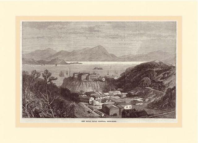
Appeared in the Illustrated London News, 1873, with the text:
The Naval Hospital was formerly the private residence of those merchant princes, Messrs. Jardine, Matheson and Co., and is situated in the eastern and most salubrious suburb of Victoria. It has been purchased by the Admiralty at a cost of 35,000 Dollars. The hospital consists of four oblong buildings, with verandahs on all sides protecting the wards from the sun's heat, and affording ample space for recreation in all kinds of weather. The rooms are lofty and well ventilated. The hospital is well lighted with gas, and there is am ample supply of the purest water. It commands a beautiful view of the harbour. In front is to be seen Kellets Island, named after the Admiral who surveyed all the neighbouring coasts and waters; and n the distance is seen a faint outline of the mainland of China. The promontory stretching out towards Kellets Island is named Kowloon. Which has been ceded to the English, and here the military resort for ball pratice. The engraving is taken from a picture drawn by a chinese artist whose name is Afong.
Buy this: the original print is available for purchase at the Brian Seed Fine Art website. (Affiliate link - Gwulo receives a commission on your purchases at Brian Seed Fine Art.)
Comments
surviving bits of hospital
the hospital had a gate on to the beach so sick sailors did not infect the masses ,if you enter Ruttonjee Hospital from the Wanchai Rd entrance, examine the arch, bottom LHS there is an anchor carved in the stone
Can you please add this to
Can you please add this to the "place"
"The Hospital of the Medical Missionary Society"
because it shows Morrison Hill.
Stone Nullah Lane
We can see Stone Nullah Lane. at the left hand side corner .
Wonder why the hospital hill look higher than what we have now, and the area around it was much lower than we currently have .
and i cannot see the Wan chai Gap Road (renamed as Queens road east after the ww2) ... may be too narrow at the time being or had not yet built ?
re: Stone Nullah Lane
Hi Toby,
The accuracy of the old engravings varies a lot. Some were copied accurately from photos, others from sketches, and some from descriptions. So they are interesting to see, but not always 100% accurate in what they show.
The road over to Happy Valley is shown on an 1863 map (Plate 2-2, Mapping Hong Kong), so in this engraving the road already exists but it is out of sight. Interesting that on the 1863 map it is marked Queen's Road, though later maps show it marked Gap Road, and then later again it is marked Queen's Road East! I've never seen it marked "Wanchai Gap Road" though. I've only seen that name used for the road slightly west of Stone Nullah Lane, running from Queen's Road up to Wanchai Gap.
Regards, David