Current condition
Demolished / No longer exists
Date completed
Date closed / demolished
(Day, Month, & Year are approximate.)
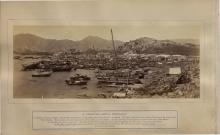
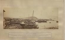
Hard to believe it now, but when this opened it stood on the seafront! The street in front, running along the water's edge, was (and still is) named Reclamation Street.
The street behind it took it's name from this building and was named Station Street (later renamed to Shanghai Street).
Reference: Relationship between street names and the Force, in HK Police 'Offbeat' magazine.
Photos that show this Place
1874
1874
1900s
Comments
The next Yau Ma Tei station
The next Yau Ma Tei station was built a couple of blocks further West, after further reclamation meant this building was now inland. See:
https://gwulo.com/node/15771
Court & Magistracy
After the new Police Station opened, this building was used as "a Police Court and Magistracy for Kowloon and District". Its new role was announced in item 161 of the Government Gazette for March 21, 1924:
No. 161.—Notice is hereby given that a Police Court and Magistracy for Kowloon and District will be opened at the old Police Station Building, Yaumati, on Monday, the 14th April, 1924. Persons charged at the following police stations :—
(1) Water Police Station, (other than Harbour cases),
(2) Yaumati Police Station,
(3) Mong Kok Police Station,
(4) Sham Shui Po Police Station.
(5) Kowloon City Police Station,
(6) Hung Hom Police Station,
(7) Tsun Wan Police Station, (excluding cases usually taken by the District Officer, South),
(8) New Territory, (excluding Tai O and Cheung Chau and excepting cases usually taken by the District Officer, North),
will be brought to the Kowloon Magistracy for trial.
Yau Ma Tei Welfare Association
These buildings remained in use for several decades after the Police moved out in the 1920s. If we look at the maps of Kowloon in "Mapping Hong Kong", the 1902 map shows the T-shaped Police Station building, and the same building is still there on the 1947 map.
This commercial map from 1956 also shows it, labelled as the Yau Ma Tei Welfare Association.
The building was a problem for road traffic, as it meant two sharp bends in an otherwise straight Shanghai Street. Back to "Mapping Hong Kong", and the 1964 map shows the building had been demolished, and the road straightened out at last.
I've set the demolition date as c.1960, taking the mid-point between the 1956 & 1964 maps. Any more accurate information about the demolition date welcome.
Location of Delmar
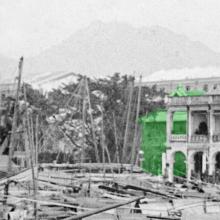
I wonder if the Police station building was originally a property called Delmar. From Zolima:
In the 1870s, Delfino Noronha and Marcos Calisto do Rozario bought a five-acre property next to the beach and built a villa they called Delmar, a combination of the first syllables of their given names. The lush garden included pineapple trees and trees imported from Australia. Noronha could afford it – he was the founder of the first ferry line to run between Kowloon and Hong Kong Island.
Source
Edit: Location was further north here