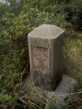
War Department Telephone Cable Marker Stone [c.1937- ]
- Read more about War Department Telephone Cable Marker Stone [c.1937- ]
- Log in or register to post comments
War Department Telephone Cable Marker Stone, indicating buried telephone cable
War Department Telephone Cable Marker Stone, indicating buried telephone cable
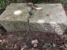
At we research the boundary of ST. Raphael's Catholic Cemetery, We find a mark on 1922 1:600 map "D" on the NK/NT boundary, according the position , we find NK/NT Boundary stone near Caldecott road
there are mark on stone
”New Kowloon “
“New Territories”
“Limit under ordinance No.26 of 1937”
Thanks to Herman's previous findings in https://gwulo.com/node/48552 so as historicalwalk, I visited this boundary stone but the markings are not in very good condition.
Two and half sides are covered and I tried not to disturb its silence at this moment.
Found this marker stone on a track beside Hong Kong Trail Section 2
I cannot identify the wording but maybe something like
LL
X776
Any idea what is this?
Hi There,
While walkinga long the refurbished foot path away from Emplacement two toward the stairs of the Sunset Pavilion, right at the intersection there seemed to be a marker made of crude concrete. I could not make up any marking though. Marker is approximate. Will try to refine position next time.
Whoever walking by are welcome to verify.
T
Jat's Incline has become one of our regular walks, and I'd noticed it has a marker stone a short distance uphill from the temple. The stone is down at bottom left in this view, and the yellow-coloured rock in the distance is part of the temple.
Marker is approximate. There are three concrete marker pillars behind the bus top where two of them could be seen in Street View.
The wordings are on the inside.
I found this stone on Beacon Hill today; and the obvious question is: what is this? The markings are heavily weathered, though in the short time I had to look at it I could make up the number "1902", I guess that's the year the stone was created.
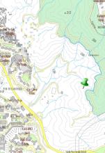
Location: N 22° 20.875 E 114° 10.110, just off Lung Yan Road.
The marker is approximate. However for the accuracy of the then Royal Navy Engineers/Survayers I am pretty sure the stone used to sit exactly on the 114'30" E longitude.
Thanks for JW for this piece of Old News. Back in 2007 archeologists in Shenzhen had discover this stone marker at the tip of the Xichong (西沖)。 It was the boundary marker setup by the British for the seaward boundary concerning the taking (or lease, depends on how you look at it) of the New Territories.
After seeing those in Sai Kung I believe this is very likely trenches. First locate the 25 Marker Stone and look around for the trenches which run along the North Easte slope of Peel Rise.
