Current condition
Ruin
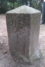
I saw this stone earlier in the week. It's at Kowloon Pass along Stage 5 of the Maclehose Trail.
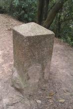
One side shows the usual 'WD" and arrow:

but the other side shows "MR', which I haven't seen before:

Map 4-4 in the 'Mapping Hong Kong' book is a 1924 map of Kowloon that extends as far north as here. The area south of Lion Rock is marked "Military Reserve", which I guess is what the "MR" stands for.
Further south, near 'Ta Ku Ling' village, the map shows a rifle range. You'd want a large area behind the rifle range off limits to avoid any acidents, so that may be what the Military Reserve was for.
Regards, David
Photos that show this Place
2012
2012
Comments
Is it near the AFCD pavilion
Is it near the AFCD Pavilion or the make shift shelter further east on Mac. Trail?
Couldn't find it yesterday... There's a construction site in that area.
Sorry, I don't remember now.
Sorry, I don't remember now. I'll take another look next time I'm in that area.
Coordinates
I came across this marker stone on the MacLehose Trail Sec. 5 a few days ago. It is roughly equidistant between the AFCD pavilion and the makeshift shelter, instead of being right next to the AFCD pavilion as the map marker suggests. AFCD has also set up an sign next to the boundary stone.
The coordinates I recorded are: 22.350755, 114.181642
Hope this helps!
re: Coordinates
Thanks for the updated coordinates - I've moved the marker to that location.
Regards, David