In 1906, something unusual appeared in the sky above Queen's Road (today's Queensway). Newspapers at the time reported it as an 'aerial ropeway', or 'overhead railway'. Today we'd call it a cable-car.
Here's the approximate route that it followed (click '+' to zoom in for a better view):
[gmap line=22.279943242564485,114.16781902313232 + 22.277578078224703,114.16710269455507 + 22.27654671906669,114.16586226227082 + 22.275513035691798,114.1656864881952 + 22.276547877363946,114.16584491729736 |line=22.27616829287479,114.16373384003236 + 22.276605129291355,114.16585814957216 |markers=letters::22.280079915830118,114.16776788239076 + 22.276823546988012,114.16581523422792 + 22.27569174250068,114.16555774216249 + 22.27636685505146,114.163669467016 |align=Center |zoom=16 |center=22.278056938741095,114.16663885116577 |width=410px |height=340px |control=Small |type=Map]
- A - "The Aerial Rope-way starts with a station on the sea-front of the Ordnance Department's Yard, where two small manual cranes will deliver the stores from a lighter direct onto the cars standing, or rather hanging, ready in the station." [1]
- B - Power-house (engine room) and Central Station
- C - Station at north-east corner of the Magazine
- D - Station at the Explosives Laboratory
A Navy project?
I usually think of the old military cantonment roughly split into Navy north of Queen's Road, and Army to the south. However a detailed map of the area [2] shows that the thin strip of land below the path of the cable, the magazine, and the Explosives laboratory all had Naval Boundary Stones marking their boundaries. Was this the main magazine for the Navy, and they built the cable-car built to give easier access?
How long did it last?
Based on the newspaper article, I'll guess 1906 as the date it was built. Then there's a map dated 'c.1924' [2] that shows it still in existence. But when was it demolished? By the second world war there was a large magazine at Little Hong Kong. If that replaced this magazine, the cable-car may have gone out of use at the same time the magazine was relocated.
Different times
There were two types of car that ran along this route "one of open round-bottomed tray shape, for carrying large shell, and the other closed cylindrical for ammunition and explosives." Can you imagine high-explosives running to and fro across Queensway today? (And especially with the recent memory of the falling Ngong Ping cable car!).
Has anyone seen it?
I haven't noticed it in any old photos from the early 20th century. But then I didn't know to be looking for it. If you fid any photos that show it, or have any information to share, please could you let us know in the comments below?
Thanks, David
References:
- Hong Kong Telegraph, 22 Dec 1906, Page 3
- 'Hong Kong. Cantonment of Victoria', c.1924. Map "HG7" viewable at the Survey & Mapping Office's "Map & Aerial Photo Library".
Photos that show this Place
Comments
kong sin wan rd
There's an old cable station on the ISF campus as well.
Google streetview.
re: cyberport bunker
I think that's an old WWII bunker but may be wrong - I remember it from before they built Cyberport and didn't realise they'd kept it. Am sure others know more about it.
re: kong sin wan rd
Gweipo, thanks for that. Old maps show a ropeway in that area that I guess was used by Dairy Farm.
So there's a good chance that it was a cable base, but ... as one lump of concrete looks much like another, please do you have any more clues about its background?
Regards, David
Pokfulam cableways
We (PFL person me) had two . A French missonary at the Nazereth Press (aka U Hall aka Lapraiks house/castle) designed one and had built so the catholic church could get round harbour fees and transport costs, for the materials needed to make their catholic books and then export them. He was an engineering whizz.
Dairy Farm next door(ish) liked it so had him built them one for the cows feed
further reading Alan le Pichons book on Bethanie or the museum at Bethany
re: Pokfulam cableways
Thanks Paul, I hadn't heard of the Nazareth one before, so that's one more to add to the list.
Cable Car over Queensway
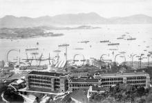
Received as is. Dated 1930s
re: Cable Car over Queensway
Thanks Moddsey, these are very welcome. I didn't think we'd be likely to find any!
I guess the photographer is standing on or near the seafront, looking south across the Arsenal yard towards Queen's Rd and beyond. There's the military hospital visible up on the hillside.
Interesting to see that the Arsenal Yard also had rails for carts, just like the Magazine further up the hill.
Cable Car over Queensway
Some interesting notes via email from Rob Weir that say the ropeway was still in use as late as 1936:
Hi David,
Just reading some details in Gwulo that I have obviously missed earlier. I found some details of the ropeway three years ago at the National Archives [at Kew, London]. It amused me, but I only made notes for myself, so it's not the official word.
It turned up in CO129/552, folio 5. Naval Armament Depot.
Agreed in 1930 that Kennedy Road Magazines would revert to the HK Government for HK$2,000,000. Someone then changed the rules, the magazine would stay, the ropeway, previously considered superfluous, would also stay. War Office, Admiralty, Colonial Office, HK Government and Secretary of State for Colonies all have inputs, all passing the buck. Unresolved when the file was closed in 1935.
CO129/556, folio 12. A continuation of 552 folio 5.
At the end of 1936, the situation was still unresolved, a comment to that effect being put forward by the Governor. The ropeway was originally installed as the stores in the magazine were military only, so the ropeway went direct to the Naval Yard. It was apparently to be removed when the magazines were closed, but when that was revised, the military stuck to their guns. A suggestion of building a road to the magazine was fine by the military, so long as they didn't have to pay for it, and it was not open to public use.
I have no ending to the story.
Might be interesting background.
Cheers,
Rob
Cable Car over Queensway
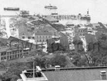
Amidst the tram powerlines, to the right is the cable car pylon with the overhead cable ropeway. The tramlines veer to the right into Arsenal Street and into Praya East.
re: Cable Car over Queensway
Well done for spotting that. Great to see a picture of it at ground level like this,
Regards, David
Demolished c.1937
Rob's notes above show the cable car was still in place at the end of 1936. But in the following photo, 'E' marks the location of the northern terminus of the cable, which has clearly been dismantled and removed. The photo is dated to November 1937, so the cable car system would have been removed earlier that year.
1937 Arsenal Yard
re: 1937 Arsenal Yard
Moddsey notes his 1937 photo was taken during the coronation celebrations in May 1937. It shows the cable car terminus was still standing then.