Current condition
Demolished / No longer exists
Date completed
(Day, Month, & Year are approximate.)
Date closed / demolished
(Day, Month, & Year are approximate.)
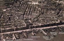
Pier opposite M.L. 234 (today's 28 Connaught Road West). It was one of the earliest piers to be constructed after Central reclamation. It appears first on the 1901 (Gwulo) map.
The 1934 map on hkmaps.hk gives the name: Cheong Wing Kue & Cheong Wing Po (EXORS) Wharf. On the 1945.3 map the name Yueng Tai Hing Wharf is used.
At the end of the 1940s, the pier was considerably shortened (to about one third compared to the original length). The 1954 map gives the name Tai Hing Wharf with the addition Public Pier No. 8.
In about 1975, the pier disappeared due to the next reclamation step.
Photos that show this Place
1927
1931

1945