There is an image in the Wellcome Collection (29773i) by Floyd, dated to 1873 though not firmly, that shows THREE chimneys. It can be seen that The Mint-become sugar refinery is on the right (the roofline exactly matches a contemporary water colour painting of The Mint when it was a mint), then there is an unidentified chimney, and then, close down on the water front, a spanking new building that one assumes is pretty new distillery. Does anyone have any ideas what the middle chimney might have served?
StephenD
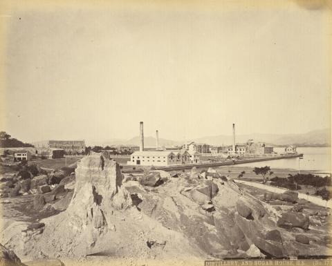
The East Point chimneys
I've labelled them in the photo below:
I think they were built in the order A, B, C, because in this photo dated to 1869, A is complete, I think I can see the scaffolding where B is under construction, but there is no sign of C.
B was definitely finished by 1874 when this photo was taken after the typhoon. It also shows that A had collapsed in the storm and needed to be rebuilt.
I'm not sure what chimney B was used for, but looking at its location next to a large, unlabelled building on this 1901 map, I wonder if it was part of an extension to the sugar refinery.
More about the chimneys
Sometimes, things (e.g. chimneys) seem to be more complicated than expected. There is a photo showing the mint which should have been taken between 1866 and 1868.
This is, of course, before the sugar refinery was built. Nevertheless, there is a chimney behind the mint. Likely not one of the ones mentioned in this thread, but this needs to be discussed further.
Another photo is from around 1880.
Here we see all three chimneys (A, B, C), but only B seems to be active. In fact, many photos showing this area have chimney B as the "smoking one".
Finally, a map from 1903.
As David had assumed that chimney B would also belong to the sugar refinery's premises, he was right. The 1903 map shows the expanded refinery with two chimneys.
re: More about the chimneys
Hi Klaus,
I believe that that the refinery occupied (and probably modified) the old mint's buildings, rather than demolishing them and building something completely new. If you zoom in to this 1874 photo, we're looking at the site from the back but we can see the shape of the roof of the main mint / refinery building is the same:
The plan of the mint shows it had a large chimney at the back (the black circle in a red square at top centre of the plan):
That is the chimney I've labelled A, shown in ruins in the 1874 photo above, and in its initial condition in your photo:
The chimneys
Klaus has produced a good answer, thanks.
The 'map', by the by, is a detail from a marine chart, rather mis-labelled 1903 on Tymon Mellor's site because the example on the HK Maps site is an 1888 chart with the latest large correction in 1900 and the most recent small correction No. VII of 1899. There was a new edition in 1903. Indeed according to the July 1912 edition (on which more below), there had been new editions in 1900, 1903, 1907, 1908, 1909, 1910 and one in April 1912 before the one in July! But Tymon's '1903' chart is none of those.
There is probably no better way of tracking the changing shoreline than going to the Old Copy Bundles in the UKHO Archive in Taunton and following the editions of HK harbour charts. The classic 'Belcher' chart (1466) saw 23 new editions and countless large and small corrections between 1845 and 1966 (and probably more because the system didn't get fully into gear until the 1870s). There are also fair copies of survey results that never got published, but that often fill useful gaps, like Mr Reed's very large scale 1866 survey of the north shore of HK Island (which has the Mint's chimney), which begat the Rifleman's Bolt, aka Colony Principal Datum and now just the HK Principal Datum or Ordnance Datum.
Anyway, with chimneys it pays to look closely. Because charts include them only when they are conspicuous enough to be useful for navigation (the conventional symbol at that time was the small circle), using a chart to identify conspicuous chimneys like this is a great idea. In fact this chart shows three chimneys (and a flagstaff) on the sugar factory and two on the distillery, so in 1900 a total of five at East Point. By the 1912 edition all but one of the chimneys are no longer shown, and the vast clump of building that was the sugar factory has resolved itself into two, with the sole "Highest Chimney" on the SE corner of the western building. That doesn't mean the other chimneys had disappeared. It means that since, for a navigator, the only thing that mattered was being able to identify the tallest, as an improvement on charting clarity, that's what the 1912 chart showed rather than any others.
StephenD