[2024 update: I originally created this Place to show the location of the army's Women's Hospital, believing it was located here. Now we see that the 'F' on the 1901 map is more likely just the identifier for the block, 'F Block', as described in the comments below. Which block was used for the Women's Hospital isn't clear at this point.]
On the 1901 map at this location there is a long building marked 'Hospital F.' (click to view on the map). I believe this stands for 'Hospital Female'. (There is a clearer copy of the map available at https://www.hkmaps.hk/map.html?1901.3)
The map shows several married quarters on the army's land near the hospital, so there needed to be medical facilities for the soldiers' wives.
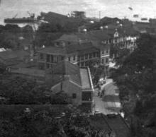
I believe the building is the three-storey building with verandahs shown on the right of this photo:

On the 1950s map of this area it is labelled 'Nelson'. By that time it was part of HMS Tamar, which occupied the Wellington Barracks site.
Photos that show this Place

Comments
hospitals
again thank you so much for this invaluable information. I remain confused though but I suppose that this is what this research is all about!
re: hospitals
Yes, confusion is the norm with new questions, but things usually get clearer as more information surfaces. If you have any questions about the hospital, feel free to post them here.
Hospital for Soldiers Wives and Children, Wellington Barracks
I think this place is referred to in the following newspaper advert.
Perhaps the official or full name of the Hospital was "Hospital for Soldiers Wives and Children" or "Station Hospital, Wellington Barracks"?
Confused! Yeeha, welcome to the club.
Good Find
Absolutely good find.
For general reference, The Army Medical Report for the Year 1896 mentions the Station Hospital for European troops is partly on the harbour ship "Meanee" and partly on shore in the Wellington Barracks.
re: Hospital for Soldiers Wives and Children, Wellington Barrack
That is a good find.
Here's the list of RAMC staff from the 1902 Directory & Chronicle:
It also uses the description 'Station Hospital', but lists Civil Surgeon Beringer as in charge of the 'Female Hospital and Officers Women and Children'.
I think the 1901 'Hospital F.', 1902 'Female Hospital', and 1903 'Hospital for Soldiers Wives and Children' are likely all different names for the same building.
I don't think the letter F…
I don't think the letter F stands for Female. Looking at the 1901 & 1901.3 maps on hkmaps, various buildings along Queensway are labelled A-G from west to east, starting with the Military hospital below Headquarters House (A,B) , the Men's Quarters (C,D) , Married Quarters (E), building to the left (G) and this building labelled F. I think it more likely that these letters were a military label for the various blocks along Queensway.
In the period before the construction of the military hospital on Bowen Road different buildings within the military cantonment were used as hospital buildings, including one of/all the main buildings in Wellington Barracks,the building labelled F as well as the military hospital below Headquarters House. I have not found any information on which building was used as a hospital for the soldiers wives/dependents.
re: I don't think the letter F…
The 1901.3 map looked to have a period after the F, unlike the other letter labels on that map. But it isn't a very strong argument so your explanation may be the right one. Hopefully other maps or documents will clarify the location of the hospital for the Soldiers Wives and Children.
Women's Hospital
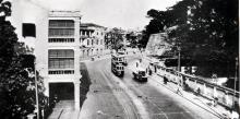
This photo shows the curve of Queen's Road/Queensway near Wellington Barracks in easterly direction. The building on the left could be the Women's Hospital, but I'm not sure.
In the bottom right photo…
In the bottom right photo from an album that recently sold at auction the caption reads "F Block Queens Road HK" I believe it refers to this building
Agreed, F Block it is. I've…
Agreed, F Block it is. I've updated the title and added a note above. The location of the Women's Hospital remains a mystery.
Hospital?
See this photo from c.1870:
On this photo are the three main buildings of Wellington Barracks. The building named F Block seems not to be there. There is a smaller building which could have been the Women's Hospital. It was probably demolished before c.1880 and replaced by a larger building which is F Block on the photos posted so far.