This location was not on the same ridge as the one you mentioned. It's lower down the slope on another side with no distinct path leading to it, I was only able to locate it after a hiking group has been there beforehand. Hence if the vegetation hasn't been cleared a bit recently, it might be rather hard to access.
Whilst bushwhacking through the summit of Violet Hill, I discovered ruins that look more or less the same as yours. It is located midway above the hill in the midst of extremely dense vegetation. The ruins are less intact than yours, with most of them being stone walls and foundations. Nearby, there is a large amount of blocked up tunnels, which makes me think they are Japanese. Pretty cool place to visit.
R.A.F. Little Sai Wan had its own water supply that, in the time that I was there in the mid 1950s, never failed.
I wonder whether the construction that you have found might be the source of that supply. In late 2000, I walked down the old camp road (the Leaping Dragon Trail) and about half way down and close to the road was a broken water pipe. It a diameter of about 3 or maybe 4 centimetres and had water gushing out of it. I thought at the time it was probably a relic of our old 'private' water supply. If it had been part of the mains supply I don't think that it would have been allowed to leak so much water.
Sorry , what does FSOP mean? There are now 2 threads on this topic, which makes things rather complicated. I have just added a comment on the other thread about the strong possibility that, as Lewis suggested here, the ruins relate to a water supply for the Japanese (and probably prior to them the British) who manned the wireless station down in the bottom of the Little Sai Wan bay, and even eventually for the large 367 Signals Unit on which I served in the 1950s. Andrew
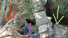
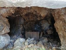
It is definitely not a FSOP, as these were built out of concrete. This building is made out of stone bricks, and it also includes a cave with a water tank. This doesn't match the layout or design of a FSOP.
Andrew, I'm not 100% sure, but I don't think this is Pre-war British. There are remnants of Japanese style concrete blocks scattered on the site, and the cave looks very distinctively Japanese. I have a theory that either the Japanese garrison occupying Pottinger Peak and it's AOP used the building as a water collection point. I don't think that the water was meant for the Little Sai Wan Camp, as there is a concrete tank in the cave that is meant to hold water. If it was meant to supply water to the camp, then there wouldn't be any reason to build a concrete tank. Instead if it was meant to supply water, then there should be a concrete channel or pipe running from the cave down to Little Sai Wan. There is no evidence of pipes of any kind near this site.
Please note my correction to the earlier comment! The diameter of the water pipe running (literally) beside the Leaping Dragon Trail was only 3 to 4cms.
As are you and others, I am still intrigued as to the purpose and age of the cave and water tank. Having never been to that site I cannot write with any real authority, but there was probably a reliable water supply from somewhere in that area down to the succession of wireless units, (pre-war, Japanese and post war) on the coast although there were, and probably still are, several streams much lower down the slope below the Cape Collinson road that would, at least in the pre 367 Signals Unit days after the war, have fulfilled that purpose. The tank does appear to be rather on the small size as a storage tank but round where I live in the English Lake District small settling/filtration tanks are installed at the head of some 'private' narrow pipelines. Is it possible that any pipeline could have been removed in relatively recent years as scrap metal?
Another mystery is that during 1958, I climbed up from the Cape Collinson road (short grass in those days) and found a very deep water catchment 'canal' contouring around the flank of Pottinger Peak, probably just below the contour where you have spotted the cave and tank. I cannot be certain where it went but have always believed that it went r0und to the Tai Tam Gap and thence into the Tai Tam Tuk reservoir. It was bone dry when I explored up there and somewhere in the 367 Gallery there should be a photograph of a group of young airmen in that same catchwater. I'll try to find it and add it here when I've loaded this comment. Incidentally, there is a narrow pipe (still protruding from a roadside cliff at CC42 and visible on Google Earth Street View) from which people fill their containers - although I suspect that the water is not as pure as it used to be.
I honestly don't think we can figure the origin of this building unless we visit the site first hand. I think we should organize some sort of group to go to this location, and investigate. I found a youtube video of this building.
Comments
access
Hi, do you know how to access this location? I think this location could be related to this structure nearby:https://gwulo.com/node/22122#17~22.25428~114.25076~Map_by_GovHK-Markers…. I feel this could be a water collection point for the Japanese troops stationed there.
This location was not on the…
This location was not on the same ridge as the one you mentioned. It's lower down the slope on another side with no distinct path leading to it, I was only able to locate it after a hiking group has been there beforehand. Hence if the vegetation hasn't been cleared a bit recently, it might be rather hard to access.
Violet Hill
Hi H
Whilst bushwhacking through the summit of Violet Hill, I discovered ruins that look more or less the same as yours. It is located midway above the hill in the midst of extremely dense vegetation. The ruins are less intact than yours, with most of them being stone walls and foundations. Nearby, there is a large amount of blocked up tunnels, which makes me think they are Japanese. Pretty cool place to visit.
Violet Hill
Lewis,
According to your description, that may be another one of similar type, though ours are looking located on different hills.
building
Hi
Just asking, do you have any opinions on the purpose of these structures?
None in my opinion, though…
None in my opinion, though some said it's probably built by the Japanese army.
Hi.R.A.F. Little Sai Wan…
Hi.
R.A.F. Little Sai Wan had its own water supply that, in the time that I was there in the mid 1950s, never failed.
I wonder whether the construction that you have found might be the source of that supply. In late 2000, I walked down the old camp road (the Leaping Dragon Trail) and about half way down and close to the road was a broken water pipe. It a diameter of about 3 or maybe 4 centimetres and had water gushing out of it. I thought at the time it was probably a relic of our old 'private' water supply. If it had been part of the mains supply I don't think that it would have been allowed to leak so much water.
CORRECTION The pipe diameter was only 3 or 4 cms!
Andrew
FSOP?
FSOP?
Sorry , what does FSOP mean?…
Sorry , what does FSOP mean? There are now 2 threads on this topic, which makes things rather complicated. I have just added a comment on the other thread about the strong possibility that, as Lewis suggested here, the ruins relate to a water supply for the Japanese (and probably prior to them the British) who manned the wireless station down in the bottom of the Little Sai Wan bay, and even eventually for the large 367 Signals Unit on which I served in the 1950s. Andrew
[Observation Posts] Pottinger Peak FSOP
https://digital.lib.hkbu.edu.hk/1941hkbattle/en/data.php?show=item&id=F…
Thank you. I have asked…
Thank you. I have asked David whether he can consolidate these two threads.
japanese building.
Hi there
It is definitely not a FSOP, as these were built out of concrete. This building is made out of stone bricks, and it also includes a cave with a water tank. This doesn't match the layout or design of a FSOP.
Andrew, I'm not 100% sure, but I don't think this is Pre-war British. There are remnants of Japanese style concrete blocks scattered on the site, and the cave looks very distinctively Japanese. I have a theory that either the Japanese garrison occupying Pottinger Peak and it's AOP used the building as a water collection point. I don't think that the water was meant for the Little Sai Wan Camp, as there is a concrete tank in the cave that is meant to hold water. If it was meant to supply water to the camp, then there wouldn't be any reason to build a concrete tank. Instead if it was meant to supply water, then there should be a concrete channel or pipe running from the cave down to Little Sai Wan. There is no evidence of pipes of any kind near this site.
Hi Lewis Please note my…
Hi Lewis
Please note my correction to the earlier comment! The diameter of the water pipe running (literally) beside the Leaping Dragon Trail was only 3 to 4cms.
As are you and others, I am still intrigued as to the purpose and age of the cave and water tank. Having never been to that site I cannot write with any real authority, but there was probably a reliable water supply from somewhere in that area down to the succession of wireless units, (pre-war, Japanese and post war) on the coast although there were, and probably still are, several streams much lower down the slope below the Cape Collinson road that would, at least in the pre 367 Signals Unit days after the war, have fulfilled that purpose. The tank does appear to be rather on the small size as a storage tank but round where I live in the English Lake District small settling/filtration tanks are installed at the head of some 'private' narrow pipelines. Is it possible that any pipeline could have been removed in relatively recent years as scrap metal?
Another mystery is that during 1958, I climbed up from the Cape Collinson road (short grass in those days) and found a very deep water catchment 'canal' contouring around the flank of Pottinger Peak, probably just below the contour where you have spotted the cave and tank. I cannot be certain where it went but have always believed that it went r0und to the Tai Tam Gap and thence into the Tai Tam Tuk reservoir. It was bone dry when I explored up there and somewhere in the 367 Gallery there should be a photograph of a group of young airmen in that same catchwater. I'll try to find it and add it here when I've loaded this comment. Incidentally, there is a narrow pipe (still protruding from a roadside cliff at CC42 and visible on Google Earth Street View) from which people fill their containers - although I suspect that the water is not as pure as it used to be.
Andrew
pump station and water tank in Dragon Trail
pump station and water tank in Dragon Trail
https://gwulo.com/node/60013…
https://gwulo.com/node/60013#17~22.26154~114.25197~Map_by_GovHK-Markers…
Military Building
Hi
I honestly don't think we can figure the origin of this building unless we visit the site first hand. I think we should organize some sort of group to go to this location, and investigate. I found a youtube video of this building.
https://www.youtube.com/watch?v=G8iiLwgocW8&t=174s
I think that water catchment still exists to this day, and it is one of the ways to access this building.
Lewis