Named after: Shing Wong, the god who protects a city.
Timeline:
- 184?: Street first laid out.
Other points of interest: From c.1844-1877 there was a Shing Wong Temple on this street.
Current condition
In use
Photos of this street:
(see more)

Comments
Re: Shing Wong (城隍)
Hi There,
I guess this page by Tung Wah has a bit more information: It originated from the form of a local diety of ancient walled cities\city states.
T
Re: Shing Wong (城隍)
Thanks T, I've added in a note above.
points in time
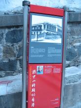
This photo showed an auxiliary information plate of the 1st generation Sun Yat Sen Historical Trail. It was beside the stone wall of PMQ at southwest corner, several steps down Shing Wong Street. The oldest Google street view that can show its location is back on 2011.
It is said that Dr Sun had once dwelled in the Congregational Church at 2 Bridges Street (c. 1884-1886). The then Government Central School he attended was at 44 Gough Street. So the plate serves to tell the proximity, just about one block's walk.
Such auxiliary information plates no longer exist in the current generation of the Trail. With those artistic markers nowadays, alas related history may be becoming obscure and its footsteps vanished into a real trail.
Other events of the time :
Hong Kong had its Observatory established in 1883 while the Meridian Marks for measuring time was first built (*) next. That year was 1884.
(*) the 'South Mark' was on Wanchai mid-levels, close to existing Bowen Road (Fitness Trail)
postscript : I only come to know this evening that 'South Mark' has been discussed under
White obelisk on side of hill above Wanchai, as early as 2016. Gwulo-ver's, applause !