From: Sailing Directions for Western Shores of South China Sea. 1978
Ngan Ying Chau (Ngai Ying Chau), a reef-fringed island, lies close off the northeast end of Tsing Island. It is separated from it by a narrow passage which nearly dries. A beacon stands on the southeast extremity of the reef extending southeastward from Ngan Ying Chau.
Channel Rocks, a group of rocks, some of which dry, lie on the east side of the fairway, about 350 yards southeastward of Ngan Ying Chau. A LIGHTED BEACON, painted in black and white with a black triangular topmark, marks the west edge of the rocks. A black and white banded pole BEACON, surmounted by a black triangle, stands off the point on the eastern side of the channel about 400 yards northward of the lighted beacon. The fairway between these rocks and the reef extending southeastward from Ngan Ying Chau is about 175 yards wide.
Still in use (P3534) , near the Rambler Channel Typhoon Shelter breakwater.
Photos that show this Place
Comments
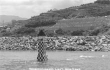
Rambler Channel Rock Beacon
3 unlit beacons were placed in the Rambler Channel in 1951
-On the extremity of the reef at Nga Ying Chau (Port hand)
-On the extremity of the reef just off the Texaco Terminal (Starboard hand)
-On the Rambler Channel Rocks (Starboard hand)
(Information courtesy of Dr. Stephen Davies)
The beacon on the Rambler Channel Rocks was lit by c.1962 (possibly with acetylene apparatus) and was converted to battery/electric operation using a Stone-Chance marine lantern by the late 1960's/early 1970's. A landing platform for maintenance staff was built in the 1980's. Until the 1990's, the beacon was painted in B/W checkers and had a triangular topmark as to signify that it is a starboard-hand beacon. After the 1990's, the topmark was removed and the beacon painted white.