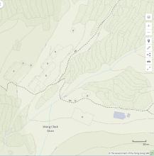
Wong Chuk Shan - Yellow Bamboo Mountain.
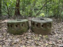
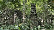
We passed the remains of this village yesterday. It is on an old boulder trackway that is still in good condition, and the many stone terraces in the area are also in good condition.
There's nothing to see on the modern map above, but if we switch to the 1952 map, the village was one of the larger villages in the area. James Hayes, in his notes on the village from the mid-1950s, recorded 133 people living there. He wrote "apart from farming, the main occupation of the men seems to be the construction business. Several employ their own relatives and other male villagers from the Sai Kung area, and travel around the New Territories building houses." Source, p.19 in Beyond the Metropolis: Villages in Hong Kong.
Those construction skills help explain the good condition of the paths and walls around the village. However, Hayes also gives the villagers' reliance on construction work as a reason for them abandoning the village: "[The inhabitants moved away] and it became completely abandoned in the 1970s. The death-knell of the village was the switch to concrete rather than the traditional stone and brick houses, rendering the village's artisan skills no longer wanted."
I don't think they moved far though, as if you follow the trail from here to Sai Kung, the first modern houses you meet on the outskirts of Sai Kung are in an area called the Wong Chuk Shan New Village.
Photos that show this Place
Comments
Re: Wong Chuk Shan Sun Chuen
Hi David,
Oddly enough, if you view it through Google Maps, a big portion of Wong Chuk Shan Sun Chuen had been re-developd as the present day Greenpeak Villa blocks, with only a few exceptions along Pak Kong Au Road.
T
Re: Wong Chuk Shan
Hi David,
The site is listed in GeoInfo Map too. Look's like the ruins are quite extensive, comparable to the Sheung Tong village we passed through a few years back.
T
Re: Wong Chuk Shan
Thanks Thomas, that Geoinfo map is much better to see the ruined buildings:
Interesting to see that one building is staill marked in gray, so Geoinfo doesn't consider it to be a ruin. I wonder if it is a temple or village hall that has survived?
We followed the fooutpath that runs down in a 7 o'clock direction from the top. It continues in that direction to the bottom of the area shown above. That bottom section is shown on the Countryside series paper map, but oddly it isn't shown on the Geoinfo map.
GeoInfo Map menus
Hi David,
GeoInfo Map has Hiking information but it is well hidden. If you click on the menu icon on the upper left, select 'Sports and Recreation' for another sub-menu.
After manipulating the search you should be able to overlay some of the major hiking paths over your map. I am more inclinde to believe the hiking information is more or less the same as the 'Enjoy Hiking' site.
T