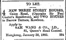
Current condition
Demolished / No longer exists
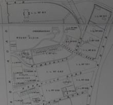
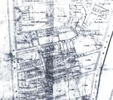
From 1901 Map. On (K) I.L. 546
A row of buildings on the south side of Granville Road between Nathan and Cameron Roads
The map shows 16 units, 8 facing north towards Granville Road, 8 facing south


Comments
Re: Barrow Terrace
Barrow Terrace on the 1901 map is on K.I.L. 546 and 548 (the latter is not marked on the 1901 map but on the 1896 one).
Amazingly the 1910 Public Works Department Annual Report states
36. Principal Works by Private Firms
Works Completed.
6 European houses on K.I.L. 522 RP and K.l.L.. 548. Section A, Nathan Road.
Don't know what this means, possibly the 1901 map showed a house to be built in future?.
I think the 1910 report means
I think the 1910 report means that Barrow Terrace sold the triangular corner of their lot (K.l.L.. 548. Section A) that was added to part of lot 522 (K.I.L. 522 RP) to make a rectangular piece of land where the "6 European Houses" were built.
The blue outline at https://gwulo.com/node/35994#19/22.29933/114.17238/Map_by_ESRI-1896_Kow… shows roughly the outline of the land for the 6 European Houses, laid over the lots 522 and 548.
"DEATH.XAVIER. - On May…
"DEATH.
XAVIER. - On May 20th, at his residence No. 6 Barrow Terrace, Kowloon, Mr LISBELLO J. XAVIER, aged 45. Shanghai and Bangkok papers please copy."
Source: The China Mail, page 4, 20th May 1909
Residents over the years
Residents
Useful to see the neighbourhood. We can see a strong Portuguese presence over the years.
1905 Jurors List
Ladies Directory 1907
Cabral, Mrs., 7, Barrow Terrace, Kowloon
Cabral, Miss, 7, Barrow Terrace, Kowloon
Silva, Mrs. A. V. da, 7, Barrow Terrace, Kowloon
1907 Jurors List
1908 Jurors List
1909 Jurors List
1910 Jurors List
1911 Jurors List
1912 Jurors List
1913 Jurors List
1914 Jurors List
1915 Jurors List
1916 Jurors List
c
Almeida
Jose' Maria d'
Clerk
HK & Shanghai Bank
5
Barrow Terrace
Kowloon
c
Costa
Antonio Fidelis da
Clerk
Liverpool, London and Globe Insce. Co.
3
Barrow Terrace
c
Gonsalves
Verissimo Claudio da Costa
Assistant
D. Sassoon & Co., Ld.
5
Barrow Terrace
Kowloon
c
Lopes
Arthur dos Anjos
Clerk
Bank Line, Ld.
6
Barrow Terrace
Kowloon
c
Lopes
Carlos Augusto
Clerk
China Mail S. S. Co.
6
Barrow Terrace
Kowloon
c
Lopes
Jose Maria de Jesus
Assistant
Standard Oil Co.
6
Barrow Terrace
Kowloon
c
Marques
Evaristo Jose
Assistant
Standard Oil Co.
6
Barrow Terrace
Kowloon
c
Neves
Florindo Jose
Clerk
Canadian Pacific Railway Co.
2
Barrow Terrace
Kowloon
c
Oliveira
Oscar Mirandolino dos Santos
Clerk
Green Island Cement Works
4
Barrow Terrace
c
Silva
Jorge Alberto Britto
Assistant
E. D. Sassoon & Co., Ld.
1
Barrow Terrace
Kowloon
c
souza
Virinto Boniface de
Accountant
Alex. Ross & Co.
3
Barrow Terrace
1917 Jurors List
1918 Jurors List
1919 Jurors List
1920 Jurors List
1921 Jurors List
1922 Jurors List
1923 Jurors List
1924 Jurors List
1925 Jurors List
1926 Jurors List