From 22.328688, 114.262118 to 22.329605, 114.262343 based on my notes from 2013 (copy below), and today's post by mountaingirlhk
Original post on Tue, 2013-09-17 22:28:
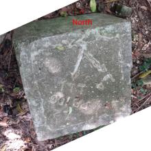
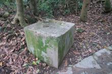
Position approximate. I saw it last week on a walk from Hang Hau up to UST. The trail goes up over a peak, then down to this point where the path meets another flat path that skirted around the hill.
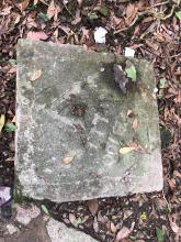
If you stand facing SSE, the slab has two arrows:
One directs you to the left around the hill towards "L4", and a clearly visible trench leads off in that direction.
The other directs you to the right around the hill towards "PB100" and "LL1". The cut-away hillside shows there was a trench here too, but this is now a well-used walking trail, so the trench is mostly filled in.
(Note to self: If taking photos of slabs in future, it'd be good to mark which direction is north, to help orientate when looking later. Could be just put a coin on northern point, or a compass if there's one available.)
Comments
Position updated
From 22.328688, 114.262118 to 22.329605, 114.262343 based on my notes from 2013 (copy below), and today's post by mountaingirlhk
Original post on Tue, 2013-09-17 22:28:
Position approximate. I saw it last week on a walk from Hang Hau up to UST. The trail goes up over a peak, then down to this point where the path meets another flat path that skirted around the hill.
If you stand facing SSE, the slab has two arrows:
(Note to self: If taking photos of slabs in future, it'd be good to mark which direction is north, to help orientate when looking later. Could be just put a coin on northern point, or a compass if there's one available.)