Been there yesterday in the rain looking for another subject, didn't realize yours is nearby. We cut through dense bamboo "jungle" from the cemetery on the knoll, passing a trench which ran along the contour.
We stopped at a level dirt path which was dense on our right, so we took the left turn to a wide spur on which GeoInfo Map shows a wide path, while there's no trace of it anymore in the real world. At last we fought through dense bamboo jungle on upper ground and passing another section of the trench before reaching the cemetery again.
Comments
Any pictures of this? Any
Any pictures of this? Any path leading to it ?
Is it in the dense forest or open area?
Slab Marker
Sorry, can't offer much. Haven't been in the area for many years.
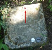
I've added a photo I took of
I've added a photo I took of this slab back in 2014, but sorry I don't remember clearly how we got there.
The coordinates I noted at the time were 22.367023, 114.215440 but they will be approximate as I'd have just been using my mobile phone.
There's another pin on the
There's another pin on the map close to yours, with similar information ... Are they referring to the same marker stone?
Yes, they're both the same
Yes, they're both the same marker stone. I've hidden the other pin to avoid further confusion.
Been there yesterday in the
Been there yesterday in the rain looking for another subject, didn't realize yours is nearby. We cut through dense bamboo "jungle" from the cemetery on the knoll, passing a trench which ran along the contour.
We stopped at a level dirt path which was dense on our right, so we took the left turn to a wide spur on which GeoInfo Map shows a wide path, while there's no trace of it anymore in the real world. At last we fought through dense bamboo jungle on upper ground and passing another section of the trench before reaching the cemetery again.