The bridge over the Bowrington Canal was probably built at the end of the first phase of reclamation at Wanchai (1864-66). Only 25 years later the following was reported:
82. Re-construction of Praya Bridge over Bowrington Canal.—The necessary wrought-iron girders for the reconstruction of this bridge having been obtained from England, a contract was entered into with Messrs. CHAN A TONG & CO. for their erection and for the masonry work required; and with Messrs. FENWICK & CO. for the construction of cast and wrought-iron railings in November last.
83. This bridge is 19 feet wide and has three spans of 29 feet 6 inches.
84. On examination it was found that the foundations of the piers and abutments of the old bridge had been considerably undermined. These have now been protected with sheet piling and a concrete apron laid.
85. The tops of the piers have been levelled ready to receive the girders.
86. Satisfactory progress has been made by Messrs. FENWICK & CO. with the iron railings.
Bowrington Canal was built during the mid to late 1850s, fed by Wong Nai Chung. Because the long and narrow canal resembled the neck of a goose it was known as Ngo Keng Kan (鵝頸澗; "goose neck stream"). It was used by small vessels that could pass under various bridges along the route. The landmark Bowrington Bridge across the canal, built in 1861, was known as Ngo Keng Kiu (鵝頸橋; "goose neck bridge") and carried the Hong Kong Tramways line across the waterway. The surrounding area is also known as Ngo Keng.
The canal was finally covered and made subterranean and the bridge removed during the reclamation from 1922 to 1929 that created modern Wan Chai (the Praya East Reclamation Scheme).
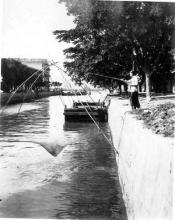
Wikipedia's comment that "The canal was finally covered and made subterranean and the bridge removed during the reclamation from 1922 to 1929 ..." isn't correct, as this Harrison Forman photo from the 1940s shows that although the canal had been made narrower, it was still uncovered:
This photo appeared to be on the Leighton Road side. I remember was further extended towards Wong Nei Chung Road close to Queen's Road East. I could not recall exactly when the whole length of it was fully covered but back in the late 1960's, the Wong Nei Chung Road section was still opened. The old Wet Market had covered a section of it when it was built. But my speculation would be it was fully covered before the Cross Harbour Tunnel was inaugurated as part of the Canel Road fly overs were built.
Wikipedia is a valuable source, but unfortunately not always totally correct. Starting with your comment, I did some research on the Wanchai reclamation (Praya East Reclamation). So I found a report from early 1931 in which the following is given:
(j)Three reinforced concrete bridges were constructed to span the Bowrington Nullah and the bridge at Leighton Hill Road was reconstructed. Of these bridges, that on Hennessy Road is 100 feet wide and carries a double line of tram track, the bridges on Lockhart and Gloucester Roads are each 75 feet wide. The level of Leighton Hill Road was raised, this involved the reconstruction of the Leighton Hill Road Bridge.
So the date of removal of the 1892 bridge is quite correct (which was about 1928-29). But the canal wasn't covered then. Instead, a new bridge was built. The cover was built later with the construction of the flyovers (as Thomas pointed out).
Comments
Bridge Reconstruction
The bridge over the Bowrington Canal was probably built at the end of the first phase of reclamation at Wanchai (1864-66). Only 25 years later the following was reported:
Public Works report for 1891
82. Re-construction of Praya Bridge over Bowrington Canal.—The necessary wrought-iron girders for the reconstruction of this bridge having been obtained from England, a contract was entered into with Messrs. CHAN A TONG & CO. for their erection and for the masonry work required; and with Messrs. FENWICK & CO. for the construction of cast and wrought-iron railings in November last.
83. This bridge is 19 feet wide and has three spans of 29 feet 6 inches.
84. On examination it was found that the foundations of the piers and abutments of the old bridge had been considerably undermined. These have now been protected with sheet piling and a concrete apron laid.
85. The tops of the piers have been levelled ready to receive the girders.
86. Satisfactory progress has been made by Messrs. FENWICK & CO. with the iron railings.
Public Works report for 1892
105. Re-construction of Praya Bridge over Bowrington Canal.—This work was completed and opened for traffic in March last.
History of Goose Neck Bridge
From Wikipedia:
Bowrington Canal was built during the mid to late 1850s, fed by Wong Nai Chung. Because the long and narrow canal resembled the neck of a goose it was known as Ngo Keng Kan (鵝頸澗; "goose neck stream"). It was used by small vessels that could pass under various bridges along the route. The landmark Bowrington Bridge across the canal, built in 1861, was known as Ngo Keng Kiu (鵝頸橋; "goose neck bridge") and carried the Hong Kong Tramways line across the waterway. The surrounding area is also known as Ngo Keng.
The canal was finally covered and made subterranean and the bridge removed during the reclamation from 1922 to 1929 that created modern Wan Chai (the Praya East Reclamation Scheme).
Wikipedia's comment that "The
Wikipedia's comment that "The canal was finally covered and made subterranean and the bridge removed during the reclamation from 1922 to 1929 ..." isn't correct, as this Harrison Forman photo from the 1940s shows that although the canal had been made narrower, it was still uncovered:
Re: Ngo Keng Kiu
Hi David,
This photo appeared to be on the Leighton Road side. I remember was further extended towards Wong Nei Chung Road close to Queen's Road East. I could not recall exactly when the whole length of it was fully covered but back in the late 1960's, the Wong Nei Chung Road section was still opened. The old Wet Market had covered a section of it when it was built. But my speculation would be it was fully covered before the Cross Harbour Tunnel was inaugurated as part of the Canel Road fly overs were built.
Maybe we could pick Moddsey's brain on this......
T
Goose Neck Bridge
Hi David,
Wikipedia is a valuable source, but unfortunately not always totally correct. Starting with your comment, I did some research on the Wanchai reclamation (Praya East Reclamation). So I found a report from early 1931 in which the following is given:
(j) Three reinforced concrete bridges were constructed to span the Bowrington Nullah and the bridge at Leighton Hill Road was reconstructed. Of these bridges, that on Hennessy Road is 100 feet wide and carries a double line of tram track, the bridges on Lockhart and Gloucester Roads are each 75 feet wide. The level of Leighton Hill Road was raised, this involved the reconstruction of the Leighton Hill Road Bridge.
So the date of removal of the 1892 bridge is quite correct (which was about 1928-29). But the canal wasn't covered then. Instead, a new bridge was built. The cover was built later with the construction of the flyovers (as Thomas pointed out).
Regards, Klaus
Bowrington Canal
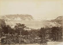
The Bowrington Canal can be seen on the right.