Current condition
Demolished / No longer exists
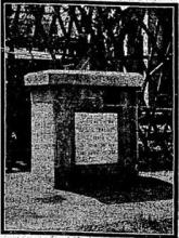
The 1888 BA chart China Southeast Coast: Hong Kong Harbour, surveyed 1886-87, shows this interesting oddity, which may have been around until the naval yard extension work began, was close to the shoreline, pretty much in line with the VRC's swimming enclosure. It is labelled "Palos Pier. Obsn spot of Comdr Green U.S.N."
This was the US Navy's role in more firmly establishing HK's longitude in 1881 before the HK Observatory got on a roll. The result gave HK its only (now long gone) mapped feature named after a US warship: Palos Pier. The pier wasn't a pier but, rather (I think - this is a guess based on the conventional symbol used) something that appears as the Merriam-Webster 4th definition: "a structural mount (as for a telescope) usually of stonework, concrete, or steel". It stood pretty much where Hutchison House is today and was the site where Lt Commander Francis Mathews Green USN, used the recently landed submarine cable to establish HK's longitude with great accuracy in 1881.
I've long wondered who he was, all I know thus far being that he was Lieutenant Commander Francis Mathews Green USN (1835-1902), that he was born in Boston, Massachusetts, to Mathews Wylly Green and Margaret Augusta Gilchrist, appears possibly first to have married Catherine Lovell Cushing in c.1863 in Charlestown NH, who died in 1866 and with whom he had one daughter, then marrying Elizabeth Stillman Cushing (haven't found an obvious relationship yet) with whom he had a further five children (though the supposed two marriages may just be a documentary muddle). He passed away on 20 Dec 1902 in Albany, New York, USA.
In 1873 he was put in command of the US Steam tug Fortune to begin using newly installed submarine cables to verify longitudes in the Caribbean, a project that lasted until 1875. By 1882 he was CO of USS Palos (built by James Tetlow of Chelsea, Mass in 1865, sold to a Mr Yamaguchi in Nagasaki in Jan 1893 for 7,000 Yen) on the US Asiatic Station, a 4th rate iron screw tug converted to a gunboat in 1870 and the first US warship to transit the new Suez Canal under her first skipper, not Green, in 1870. I don't know when Green took command, but clearly pre-1881, possibly as early as 1879 (there's an odd entry for a CO called Green, but with the wrong initials, in the 1879 Shanghai Hong List), and he seems to have ceased being with the ship before 1883. One suspects that his job was using the newly arrived cables in SE and E Asia to verify longitudes as he had in the Caribbean and South America.
In 1875 he had been the author of a piece in Popular Science Monthly (hurrah for him): the "Telegraphic determination of longitude" - and lucidly written it is too. Between 1877 and 1885 he jointly published via the US Hydrographic Office a series of oeuvres with wondrous titles like Telegraphic determination of longitudes in Japan, China, and the East Indies; embracing the meridians of Yokohama, Nagasaki, Wladiwostok, Shanghai, Amoy, Hong-Kong, Manila, Cape St. James, Singapore, Batavia, and Madras, with the latitude of the several stations plus one or two other oeuvres of the ilk. The last authorial hit I have is in 1885, because he would seem to have been pretty permanently attached to the US Hydrographic Office, which has him as author of the standard USN sailing directions to the Caribbean and Gulf of Mexico. All I otherwise know is that in 1894, when he was working out of Room 144, Federal Building, Boston (seemingly still in the USN), he was elected to the American Academy of the Arts and Sciences.
Given that the Palos was named after Palos de la Frontera, where Columbus lit out for the unknown in 1492, Commander Green's story is one of those little snippets of HK maritime history that does the usual job of connecting HK to a very much larger world. Pity the pier went the way of so many of HK's monuments.
Best,
Stephen D
Photos that show this Place
1933
1957
Comments
Re: Palos Pier
I guess the 'pier' would be visible in this photo near North Barracks and adjacent to the swimming baths.
Murray Pier
That pier is is marked on maps from the 1880's as Murray Pier. The earliest mention of Murray Pier I can find is from 24th January 1880 when His Excellency Lau Kwan-Yih, late Viceroy of Kwangtung and Kwangsi and Viceroy elect of Two Kiang arrived with his entourage in Hong Kong, landing at Murray Pier. (Source) After the 1890's reclamation a second Murray Pier was built on the new shoreline which the VRC took over after completion of the Naval Dockyard reclamation in the mid 1900's with the clubhouse being built on the seaward end of it. Subsequently a 3rd Murray Pier was built a few hundred feet to the west opposite the United Telegraph companies offices. The third Murray Pier lasted until the reclamation of the 1950's
It seems likely that Palos Pier was actually the 1st Generation Murray Pier
When a pier isn't a pier
From Stephen's description above, I think we're looking for something more like a trig point than a pier that sticks out into the sea - must be a surveying term:
The pier wasn't a pier but, rather (I think - this is a guess based on the conventional symbol used) something that appears as the Merriam-Webster 4th definition: "a structural mount (as for a telescope) usually of stonework, concrete, or steel".
Green's Pier
Green's triangulation pier was on the North Barracks Parade ground. HKGRO 24 February 1882 refers.
From the description given in
From the description given in Government Records the 'Palos Pier' is an 'instrument pier', probably a portable device. I have transcribed the mentions of it and Commander Green from 1881/1882 below:
3rd September 1881
On The Proposal to Establish an Physical Observatory at Hongkong, by Major H. S. PALMER, R.E., F.R.A.S.
The importance of such determinations, especially as aids to marine cartography, can hardly be overstated, for it is certain that a very large proportion of the hitherto accepted longitudes, dependent on observations of the Moon or on chronometric meridian distances, are seriously incorrect. Even at a place so near to Greenwich as Lisbon, the longitude was found only two years ago to be more than two miles in error. With its longitude determined accurately by the telegraphic process, the Hongkong Observatory would furnish a fundamental meridian for these seas,- and marine charts would, or ought to, be brought into conformity with its exact position as thus ascertained.
I should recommend some special provision for ascertaining the latitude of the Observatory, if it were not that Lieutenant-Commander GREEN, U.S.N., commanding the United States’ surveying-vessel Palus, is already in these seas, engaged in the special task of determining true positions by the best modern methods, for purposes chiefly of marine cartography. In this branch of work, which has been neglected hitherto by our Admiralty, the United States’ hydrographers have already made great and valuable progress in many parts of the world. It was Lieutenant-Commander GREEN who detected the error of the Lisbon longitude above referred to; and I have no doubt that; when he comes here, he will determine the latitude of some point in the Colony with considerable accuracy. He will also ascertain our longitude, as one station in a series comprising Nagasaki, Yokohama, Shanghai, Amoy, Hongkong, Manila, Saigon and Singapore, connected at one end with Vladivostok (the longitude of which has of late been accurately re-determined by telegraph from St. Petersburg), and at the other end with Madras. This, however, will not do away With the advisability of a repetition of the longitude determination as suggested in the previous paragraph, especially as such repetition will involve only a trifling outlay.
Source
24th February 1882
On a determination of Latitude at Mount Elgin, in the KAU-LUNG Peninsula, by Major H. SPENCER PALMER, R.E., F.R.A.S.
ln the scheme for the proposed Hongkong Physical (observatory which l drew up last year for the information of His Excellency the Governor, it was explained that astronomical observations in This island would pretty certainly be vitiated by deflection of the spirit-levels caused by the neighbouring hill masses; and this was adduced as one reason for favouring a site at Kau-Lung where the conditions - at least above ground - give no cause for apprehending sensible errors of that kind.
For various reasons,Lieutenant-Commander GREEN, of the United States surveying ship ‘Palos’ whose scientific mission I described in the same paper, Was obliged, on his arrival here in September last, to establish his own observing station on this shore. But he was fully alive to the weight of the objection explained above; and subsequently, when we were speaking together on the matter he was good enough to offer to lend me one of his instruments for 1 month or two, in order that I might myself make a separate determination of longitude on Mount Elgin. With this obliging offer I gladly closed, feeling as I do the importance of having the latitude of the proposed Observatory site established with the highest accuracy possible, and under conditions free from the uncertainty which must affect an determination on this side of the harbour ,- while the fact that, relying on Lieutenant-Commander GREEN’s expected visit, I had omitted from the Observatory scheme provision for a latitude instrument left no room for doubt as to the wisdom of accepting his offer and devoting some time and trouble to a determination which should be precise and final. The operations and results are described in the following notes and tables.
Observing Hut - For shelter, I had a roomy and well-designed portable wooden observatory with the requisite openings, which was given to me by Lieutenant-Commander GREEN.
Pier: The instrument-pier is of Canton blue bricks set in Portland cement, and rests on a shallow footing of brickwork, but is not isolated below the ground-level, though it has no contact with any part of the hut. This was found to answer very well, no unsteadiness having been perceptible during ordinary movements in the hut.
Source
As to the location of
As to the location of Commander Green's station on the shore mentioned above, it was probably around or on Murray Pier as per StephenD's map form the mid 1880's. This photo from the mid 1880s shows the first generation Murray Pier but I can see no sign of anything that looks like an instrument pier:
The North Barrack parade
The North Barrack Parade Ground location that moddsey refers to:
I may also point out that it will be interesting to obtain by means of a small triangulation across the harbour, the measured difference of latitude between Lieutenant Commander Green’s pier on the North Barrack Parade Ground and my pier on Mt Elgin.
Source
Palos pier
(Admin: here's an email from Stephen, written before the above comments were posted.)
Dear David,
I have an image of the chart in reasonably hi res:
I now also have further info on the ‘pier’. Here is the description of the location from the official US Navy report:
HONG-KONG.
The observatory was situated in the yard of the Artillery Barracks, and its exact location was plotted on the official plans of Hong-Kong by the surveyor general. From the transit-pier the Cathedral tower bore S. 61° 23' 20“ W., distant 1,200.8 feet; the north angle of Wellington Battery (nearly in the meridian of the old observation spot) S. 69° 6' 15" E. distant 1,528.3 feet; and the northeast angle of the Hong Kong Club House, N. 8o° 9' W., distant 2,031 feet.
That triangulates the spot very neatly. The ‘old observation spot’ may by inference, I think, be the datum used by the RN and probably RE in the 1860s, not sure who established it. Lt Bernard Collinson RE in his Ordnance Map of 1845 seems to have used Cmdr Belcher’s datum at Observation Pt/Pt Albert near the Wanchai/Bowrington boundary, commemorated today in the very short stretch of street named Observation Place (天樂里 (Tin Lok Li)), but perhaps he or the RE used it to establish a new datum in Wellington Battery. The mention of St John’s Cathedral tower is probably because at one stage it has also been used as an RN charting datum and was, in any case, what navigator’s label a “tr (conspic.)”
I have a copy of all the technical observation details from the same report. Exactly what the pier looked like I don’t know. The Report describes those in Yokohama and one or two other places, but not in HK. However the general description given notes:
Brick piers were generally erected for the transit instruments but, on the whole, piers were preferred made of three cylinders of stone, each 22 inches in diameter and 12 inches in height.
Given the wide use of cut stone in HK, it seems probable the HK pier conformed to the second type.
I have also learned that Lt Cmdr Green joined the Palos as CO on Yokohama on 24th April 1881 and that via Yokohama, Shanghai & Xiamen (Amoy) they reached HK on 24th August. Work in HK connecting the HK meridian to that of Xiamen and Shanghai was difficult because of frequent interruptions by tropical storms. The Palos stayed in HK whilst observations at the other telegraphic stations (Bolinao, Manila, Capt St James, Saigon, Singapore & Madras) were made – the officers were moved around “by mail steamer” – and all was wrapped up by 17th Feb 1882. A few days later (not sure exactly when yet) the Palos left HK for Kobe where Lt Cmdr Green relinquished his temporary command and left for the USA, arriving in Washington on 29th April. On his arrival the telegraphic measurement of meridians project in which he’d been involved since 1874 was ended.
The HK meridian work was part of a concerted global effort to pin down the longitudes of 50 important ports around the world between c.1875 and c.1885 so that all the ‘secondary meridians’ derived from them could be verified or corrected. This was needed because all the existing data depended on astronomical observation and accurate timepieces, which led on the one hand to discrepancies of “one to four minutes of arc” (call it 0.5-4 nautical miles!) and on the other to frequent changes on data on charts and maps depending on whose observations were from time to time being credited with the greatest accuracy. The official report noted that 29 of these major port meridians were verified or corrected by the telegraphic method (it doesn’t say what method was used for the other 21), nineteen of them by US Naval expeditions.
Like so many arcane corners of HK’s history, quite fascinating and utterly typical of HK as a ‘global city’ from its earliest colonial days.
Best,
Stephen
longitude by telegraphic measurement
Thanks Herostratus and Moddsey for the additional info. I'd got the Major Palmer stuff but missed the vital data about the pier being built of Canton blue bricks.
The technique for establishing longitude by telegraph is succinctly given in:
Popular Science Monthly Volume 7 August 1875, pp.426-433
TELEGRAPHIC DETERMINATION OF LONGITUDE
By F. M. GREEN,
LIEUTENANT-COMMANDER UNITED STATES NAVY.
Stephen D