Current condition
Ruin
Wandering up from Chi Fu Fa Yuan the other day, towards Pok Fu Lam Reservoir. Went off a side trail I found on the first bridge over the small stream, eventually ended up at a pagoda and this blockhouse.
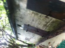
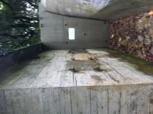
The blockhouse was nestled between two trenches on either side. windows, still with their rusty panels. A large rusty door also exists. The building appears more for storage than defense and is a standalone structure in the area. I also noticed large rusty hooks on either side of the building.
Pictures.


Comments
Re: Building in Pok Fu Lam area
Hi there,
Is there a concrete pavilion close by at the location you found please? On the other hand, your photos seemed to be rotated 90 degree anti-clockwise.....
T
Yes. There was a pavilion
Yes. There was a pavilion adjacent to this site. Does it exist already on Gwulo? Or have you found it before?
Sorry about the photos. I can try and rotate them. They came out funny.
Regards
Re: Pavilion
Hi there,
If there is a concrete pavilion next to them, your marker is quite a bit off. They are out on a loop around a small knoll. The approximate location of the pavilion is 22.260636, 114.139897
I believe I have mentioned it somewhere but did not mark it up.
T
Sorry about that. I will
Sorry about that. I will change it. I have only been up there twice.
Thank!
In any case, what was it used
In any case, what was it used for? It seems there were alot of defensive structures around Pok Fu Lam reservoir; I understand there were not many reservoirs at the time. Was it purely for defense the?
Re: Pok Fu Lam Blockhouse
Hi There,
I walked by it quite a few times in the past few years. I vaguely remember there seemed to be faded signs of dangerous goods storage either on the walls or on the metal doors. By the look of the concrete surface it doesn't look too old though. Possibly post WWII.
The block is clearly marked on the Government GeoInfo Map (http://www1.map.gov.hk/gih3/view/index.jsp). But it doesn't have have any information about the block shaded in pink.
On the other hand I also vaguely remember there seemed to be a concrete ramp on the NE side of the knoll. If you go round the loop it would be difficult to miss. No idea if the ramp and the building are related. On the other side of the ramp there is also a sunken platform of sort with a concrete boundary. I did not venture up there last few times as it was much over grown. I was not prepared for bush whacking then.
T
Hi again. Yes. It does seem
Hi again. Yes. It does seem very possible that it was a post WWII strucutre. It does not retain the exact similar design features as more definite WWII structures I have come accross.
However. It does retain the similar loopholeish/window design, with rusty panels and doors, as well as trenches. Which does make me think it must have been built a long time ago, possibly in the WWII period.
There is a strong possibility that the two are related. At Shouson Hill AA battery. The ramp leads to an area adjacent to a similar blockhouse. Could be a similar case.
Could you take a look at these bunkers I found in the area on the same day. They are much more military characteristics. Tell me what you think.
http://gwulo.com/node/32673
Re: Forward Dressing Stations
Hi There,
Those closer to the reservoir are what Dr. Solomom Bard called 'Forward Dressing Station' in his memoir. Similar structures (of the wavy top) could be found in other parts of the Island say, Mount Davis, Aberdeen Resourvoir\country park, Wong Nei Chung Gap (behind the Gas Station) and Tai Tam Country Park.
T
Ahh. I have heard of those,
Ahh. I have heard of those, makes sense. Were these areas every in action? Perhaps only at the latter stages of the battle of Hong Kong. Since Aberdeen was only taken by the Japanese very late in the conflict (if i remember correctly the 25th: day of the surrender). seems slightly strange to have built them in a seemingly isolated position near Pok Fu Lam reservoir.
regards
The Dairy Farm also had
The Dairy Farm also had several buildings around this area, so it may be related to them.
Regards, David
Re: storage for dangerous goods
Hi There,
OK, I just dug up an old photo
dated 16th December 2014 of this building. There are two signs afixed onto the wall on top of one of the iron doors. One of them is a round sign, Yellow background with B.C.F and Toxic in Black. The other is a rectangular sign, green background. A black triangle was printed in the middle with a pressurized canister icon with D.G. on either side.
A storage for dangerous goods alright. Don't know if it is still in use. Don't know if the building was private property or own by the Government though.
The location is a mystery. There is no through road wide enough a truck along the Island Trail. Only way of transport was by village vehicles, but there are steps all around even those vehicles could not climb. By helichoper, perhaps?
T