Current condition
Demolished / No longer exists
Date completed
(Day, Month, & Year are approximate.)
Date closed / demolished
(Day, Month, & Year are approximate.)
Crow's Nest (or Crows Nest) was a building on (toadys No.12) Barker Road below the former Victoria Hospital, its lot is RBL 100. It first appears on the 1909 map (there its number is 133). On the 1912 map its visible with a road leading from Barker Road to Crow's Nest:
On the 1924 map the house had the number "The Peak 464". It was possibly demolished after the end of WW II, due to looting damages(?).
There is no clear evidence for the building date. In the paper Discriminatory zoning in colonial Hong Kong: A review of the post-war literature and some further evidence for an economic theory of discrimination by Lawrence Lai an ownership for RBL 100 starts in the year 1900. This was set as the year of construction .
Later place(s) at this location
Photos that show this Place
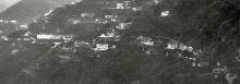
1931
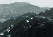
1938
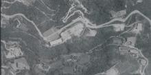
1949