Current condition
Ruin
Date completed
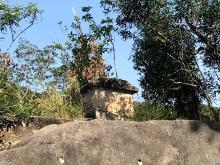
This vent prompted me to go after it.

This appears to be one of those waterworks stone markers to me.


Photos that show this Place
2020
2020
2020
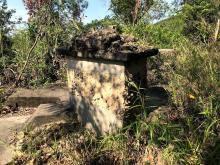
This vent prompted me to go after it.
This appears to be one of those waterworks stone markers to me.
Comments
Rob's notes
Aberdeen PB 1, Aberdeen Reservoir
Year completed is: Approximate
Condition at last visit: Intact
Date of last visit: Jul-1995
Ref: ROB-00683
Other: Sealed closed
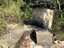
Found a stone near this PB.
Found a stone near this PB. Dunno whether it's related to this PB.
Entrance of PB1
2 loopholes facing south
Another 2 facing west
Re: Path #27
Hi There,
I believe we have resolved these stones quite a few years ago by referring to an old set of early edition of country side map published by the Government. That map has the numbered foot paths all over it, especially for paths surrounding the Peak.
There is a concentration of these markers in the Aberdeen Resevoir area, however. There is one close to Mount Kellet up in Peel Rise near the Wing On Estate. I could not recall seeing these markers anywhere else.
T
Re: Path #27
If you look at the comments on page https://gwulo.com/node/4020, there's more information about this type of marker stone, and details of the map that Thomas mentions.
Re: Path #27
Thanks Thmoas and David for the info about the marker stone :)
Re: Older photos of the stones around Aberdeen Reservoir area
Hi There,
Look's like it's time to take some photos of the stones again as some of the links I poasted back then no longer works.
Might take a while.
T